Friday, February 15, 2013

WINTER WILL FINISH WITH A FROZEN FLOURISH

1. Models still "see" the storm threat, but much less so than before. Trend since tuesday has shown this, with few exceptions (yesterday). Therefore, expect mainly light rain/snow Friday night, then again Saturday night into Sunday. Mainly dry weekend, as ferocious storm JUST misses to our east.

Accu-weather

2. Strengthening off-shore monster will make it blustery and very cold Sunday into Monday. Windy Sunday night. High struggle to the 30-degree mark Sunday, with mid-30s for Presidents' Day. Teens at night Sunday night. 

3. Rain arrives Tuesday afternoon into Tuesday night before clearing. Warmer, with highs in the 40s under cloudy skies. Some snow showers could streak in late Tuesday, but these will be light. 

4. Push of renewed cold takes hold Wednesday and beyond, with an eye towards a developing storm for late next week. Stormy pattern should continue as advertised through the rest of the month. 


accu-weather

Monday, February 11, 2013

ACCUMULATING SNOWFALL LOOKING MORE LIKELY WEDNESDAY NIGHT INTO THURSDAY MORNING


A storm which looked to be a problem for the Middle-Atlantic states is now trending more to the north with the latest model guidance. 

weatherbell Analytics 


This system would present the real possibility of delivering a 3-6 inch type storm, with a fairly high potential for impact on the morning commute for Thursday morning.
Some rain would begin Wednesday early evening, but quickly transition to snow for all areas through the evening and overnight. This looks like a fast-moving, 4-6 hour snowfall.

NOAA

PRELIMINARY SCHOOL CLOSING/SNOW DAY OUTLOOK From the great blog Weather Centre.

NOT LIKELY 

The rest of the overview is on track.
Frequent updates this week will come because of the snow threats (one for Wednesday night and the other for the weekend)
More later.

Sunday, February 10, 2013

ACTIVE, STORMY PATTERN TO CONTINUE THROUGH THE REST OF FEBRUARY

1. Dangerous travel/driving overnight for Long Island and the outer suburbs, as freezing threat looms. NYC and points south and west see mainly light rain/sleet overnight, with some slick spots. Plain rain takes over mid-morning everywhere, ending late in the day. Temps rise into the low 40s. Minor flooding likely from combination of snowmelt and rain.

NOAA

2. Windy day tuesday, but temps remain in the 40s. it will feel cold though, as winds remain fairly high through the day before subsiding at night. 

3. Wednesday night/thursday: some light rain/snow possible, but odds are low as a storm will stay to our south. 

4. Cooler weather settles in for the weekend. Watching for another winter storm late in the weekend, early next week. 


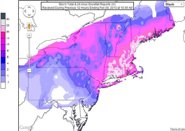
5. Blizzard this past week was historic in some places! Most spots around the city got between 6-12 inches


Thursday, February 7, 2013

VIDEO: POWERFUL BLIZZARD SET TO TAKE AIM AT THE TRI STATE AREA FRIDAY NIGHT INTO SATURDAY


SO WHAT HAS CHANGED SINCE YESTERDAY...

In a nutshell, the forecasts for snowfall accumulation from most every source for all areas of the tri-state areas have increased. In addition, the duration of the snowfall and strong wind speeds is now forecasted to last into a good part of Saturday morning, particularly for NYC and points eastward

 The reason for all of this is because most model guidance is now depicting an even stronger storm, with even greater potential for tremendous snowfall rates (per hour) from late Friday afternoon into Saturday morning. In fact, the forecast "problem" may ultimately be that the change to rain Friday morning for the coastal plain may be very short-lived!

The epicenter of the worst weather looks to be be Connecticut , with  Long Island as the candidate in New York State; Blizzard Watches have been extended through much of the Nutmeg State, with snowfall amounts from NOAA forecasted to be 18-24 inches. And, due to its proximity to the storm, and the potential for similar wind speeds, Long Island may finish runner up, with widespread totals of a foot or more when all is said and done.

This is not the last update. Another will come later today or tonight. But it is clear that a trend towards a major snowstorm is taking place, with the foreign model guidance leading the way from the get go.

stay tuned.