The winter has had some pretty impressive cold shots thus far. Going back as far as the last week of November, we've seen bitterly cold air charge in for a day or two. However, while nasty in its own right, the cold we've seen has been transient; warm air has made quick inroads, scouring out the arctic air masses. Even the blizzard back in early January was a quick memory the following week, with most of the snow cover actually being wiped out in short order.
But as mid-winter arrives, there are strong signs that a more sustained wintry pattern will evolve over the eastern two thirds of the nation.
 |
| Accuweather.com |
 |
| NOAA Temp Probabilities From Jan 23-Jan 29th, 2014 |
Beginning this weekend, successive cold shots from the north will carve out a dip in the jet stream; cold will be longer lasting and warm air will have limited opportunity to gain ground through the first week of February. Also, fast-moving disturbances will lead the arctic charge in a way that will promote deeper and deeper cold to get involved, making for times of potentially severe cold during this time frame. The combination of these two elements will ultimately mean numerous snow chances.
Through Tuesday of next week, any snow/mixed precipitation will be light. The first shots of precip will come Friday night, then again Sunday, both bringing very minor impacts to our region. However, a more organized storm will try to get going next Tuesday night into Wednesday near the coast. This storm could yield a more widespread snowfall for the region.
HIGHLIGHTS:
Friday/Saturday: light snow and rain during the day, then light snow Friday night into Saturday. Little to no accumulation.
 |
| Accuweather.com |
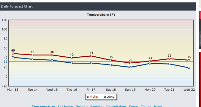
Sunday: Another close call with a weak, fast moving storm, but at worst, it's a light snow Sunday with a dusting to an inch in some spots. The bigger story is the wind Sunday, with cold temps moving in Sunday night into Monday.
 |
| Intellicast.com |
Tuesday/Wednesday: Stronger storm will develop, but its track is uncertain. A widespread snowfall would be felt if the storm is close enough to our coast. A cold shot will likely follow in for Thursday into Friday, where temps could stay in the teens and low 20s for Thursday and Friday. Watch for forecasted highs and lows to trend downward for late next week from where they are now!
Beyond the 24th: The sustained pattern of well-below normal temps should continue virtually unabated through the first 5-7 days of February.
The bottom line: Beginning this weekend, we're likely to be locked into a wintry regime, with multiple snow threats through at least the 5th of February and possibly a bit beyond that point, before the overall pattern can try and break down in a significant way!
stay tuned...

