Friday, December 6, 2013
Tuesday, December 3, 2013
ACTIVE WEATHER PATTERN SHAPING UP FOR DECEMBER
The stretch of benign weather with very little precipitation over the last few months is now transitioning to a more stormy. active picture overall. The presence of both very bitter arctic air over the Canadian Prairies (bolstered by a healthy snow cover over our neighbor to our north), as well as the typical strengthening of the jet stream, should spell lots of opportunities for rain and eventually frozen precip types as we move deeper into the month. This is in contrast to last December already; chances for storms didn't materialize until the last ten days of the month, and few of them managed to bring any wintry weather. But with the extreme contrast in air masses this month, we should look for a combination of wild temp swings (which we've seen already) and generally speaking, an uptick in storminess.
HIGHLIGHTS:
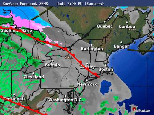
Wednesday night/Thursday: Widespread drizzle and fog should develop ahead of the warm front and continue through the morning. Light rain and drizzle should scour out in the afternoon Thursday, with very mild temps. Readings many top 60 in the normally warmer spots around the region, even in NYC.
Thursday Night/Friday: Steadier rains develop late at night and should persist through much of Friday and Friday night. Up to an inch of liquid is expected with this front. Rain will transition to snow and sleet well north and west of the city and coast Friday night, so that extreme northwestern New Jersey could pick up a light accumulation late Friday night into early Saturday morning before precip ends everywhere.
On Friday morning, it's still quite mild! However, temps will tumble steadily through the daytime hours and through the night Friday night as the winds shift to the northwest.
Saturday: Best looking day of the weekend, but we're cold again. Saturday night looks quite chilly.
Sunday-Tuesday: Complex series of storms will move through.
Potential for a wintry mix for all areas for at least a few hours during the afternoon, eventually becoming rain at the coast and in the city for Sunday night into Monday. As you head well away front the city and coast, it's more of a wintry mix scenario. This will need fine tuning.
Another storm may follow in behind for Tuesday into Tuesday night.
HIGHLIGHTS:
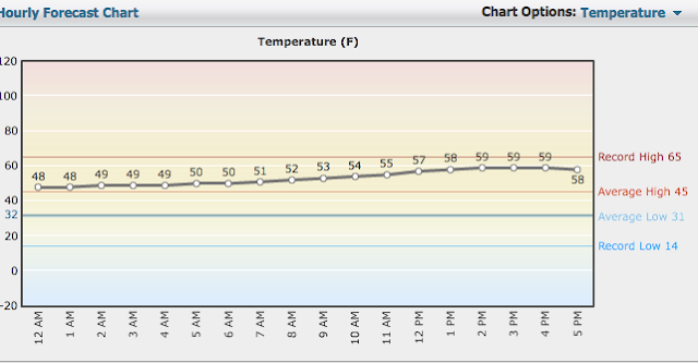
Wednesday night/Thursday: Widespread drizzle and fog should develop ahead of the warm front and continue through the morning. Light rain and drizzle should scour out in the afternoon Thursday, with very mild temps. Readings many top 60 in the normally warmer spots around the region, even in NYC.
 |
| Intellicast |
 |
| Intellicast: Hourly Temp Forecast for December 5 (Thursday) |
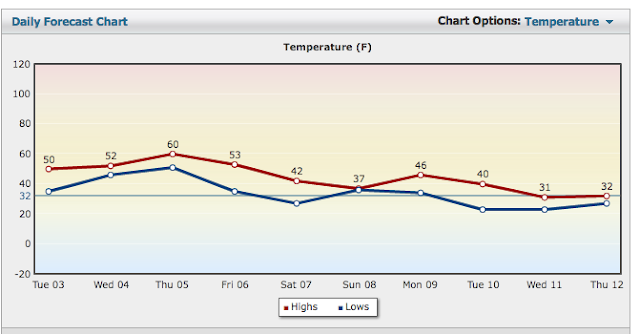
Thursday Night/Friday: Steadier rains develop late at night and should persist through much of Friday and Friday night. Up to an inch of liquid is expected with this front. Rain will transition to snow and sleet well north and west of the city and coast Friday night, so that extreme northwestern New Jersey could pick up a light accumulation late Friday night into early Saturday morning before precip ends everywhere.
On Friday morning, it's still quite mild! However, temps will tumble steadily through the daytime hours and through the night Friday night as the winds shift to the northwest.
 |
| Intellicast 7-Day Temp Forecast |
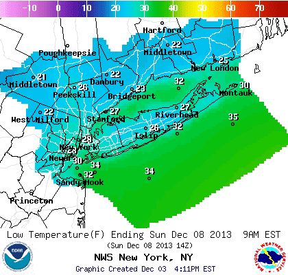
Saturday: Best looking day of the weekend, but we're cold again. Saturday night looks quite chilly.
 |
| NOAA Lows Saturday Night |
Sunday-Tuesday: Complex series of storms will move through.
Potential for a wintry mix for all areas for at least a few hours during the afternoon, eventually becoming rain at the coast and in the city for Sunday night into Monday. As you head well away front the city and coast, it's more of a wintry mix scenario. This will need fine tuning.
Another storm may follow in behind for Tuesday into Tuesday night.
Sunday, December 1, 2013
Subscribe to:
Posts (Atom)