for much of the region, a soaking rainfall will commence late tonight and continue through early Saturday morning, before tapering off. Although much of the weekend will be rain-free, the storm for Friday is looking more robust, and thus, it constituted an update here.
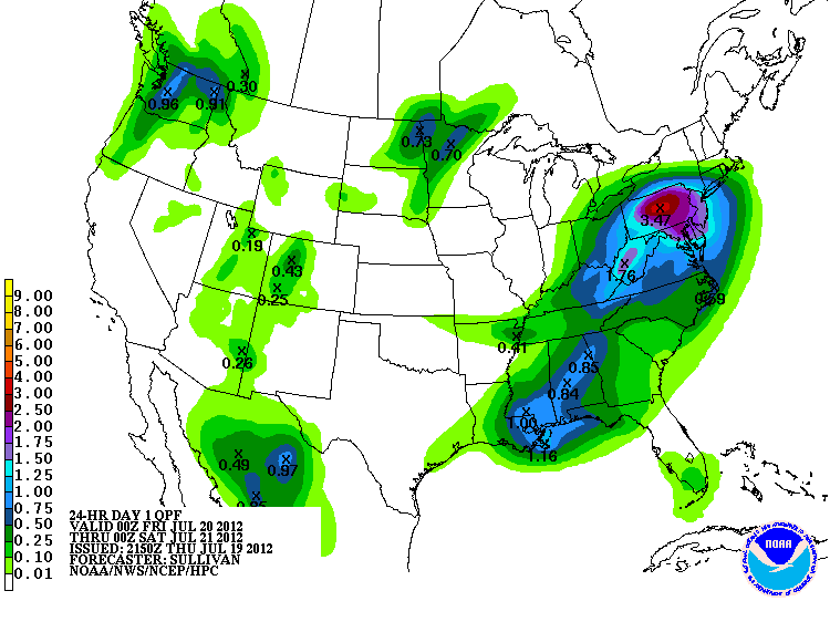
We'll use NOAA's map to decipher where the heaviest rains will fall overall. In the shaded tan areas, 1 to as much as 3 inches can fall, with even some flash flooding at times.
For NYC and points to the east, the total rainfall amount will lessen as you head east, yet many areas (except for far eastern Long Island and Connecticut) will see around or just over an inch. This is depicted nicely by NOAA's HPC graphic, showing the core of heaviest rains in red, purple and pink.
Thursday, July 19, 2012
Tuesday, July 17, 2012
A WEDNESDAY WALLOP WILL BREAK UP THE HEAT
PREDICTABILITY OF FORECAST PERIOD - Medium
1.Strong storms will threaten by mid afternoon (western parts first, then further east), and continue through early evening before winding down to just a risk of a shower by mid evening/late at night. Hot, with temps in the low 90s; muggy once again before the storms scour out the humidity.
INTELLICAST map shows that the heaviest showers/storms will wind down around sunset.
2. Numerous showers will continue Thursday and again Friday, both during the day. A lesser risk of a shower exists for areas east and south of NYC. Cooler, with highs in the 80s. Friday is predominantly cloudy. Humidity values low through the weekend.
3. Gorgeous weekend on tap, as comfortable summertime temps and low humidity values rule both Saturday and Sunday. Showers could creep in late Sunday/early Monday. Humidity and temps rise once again early next week, with another shot at 90 degrees or better by mid week.
4. Overall long-range pattern suggests a second consecutive east coast August tropical threat.
Subscribe to:
Posts (Atom)