Friday, January 3, 2014

BEYOND THE BLIZZARD, ANOTHER FIERCE ARCTIC ATTACK LOOMS FOR EARLY NEXT WEEK...

1.  After a very cold night in the wake of the storm, temps will surge Saturday night overnight into Sunday. The change in temps from Friday's bitter nighttime lows to those of Sunday will border on spectacular, with readings surging into the 40s for highs Sunday! Rain develops Sunday night, and becomes heavy into Monday morning.

Accuweather


2. Spike in temps Sunday will be swept away Monday afternoon and night by a vicious arctic air mass. This time, the mercury plummets to dangerous levels yet again for Monday night. Readings will bottom out dramatically from the 40s to the teens and single digits to near zero in a matter of hours; potential for "flash freeze" of standing water from the rainfall may lead to dangerous icing conditions on roads, bridges and transit systems for Monday night into Tuesday morning.

Intellicast


3. Continued cold for Tuesday into Wednesday, with windy conditions persisting. Temps moderate yet again for late next week, but we'll have to watch for a storm for around the 9th, which could still produce snow/mixed precip for  our region.

4. A general respite from the cold looks to establish itself around the 11th and continue into much of that week.

Tuesday, December 31, 2013

PRELIMINARY SNOWFALL IDEA FOR UPCOMING WINTER STORM...

The idea that this storm can be a bigger deal is still on the table. Subtle differences in the models could mean a far greater impact to the region.  However, the idea of a complete miss is not in the offing using all available guidance.

For now though, the combination of the very cold temps for the duration of the storm (and afterwards) plus the amounts we will receive, will leave no doubt that this is shaping up to be a very formidable period of winter weather.

The fluff factor of the storm along with gusty northeasterly winds will create whiteout conditions for a brief time early Friday morning.


Accuweather.com


A storm will affect us Sunday night into Monday, but with much warmer temps before and during
the storm.  For the Monday-Tuesday period, we should look for more bitterly cold air to dive in and produce dangerously cold conditions for a time, before temps start to come up for mid to late next week.

more tomorrow

SNOWSTORM THURSDAY AFTERNOON INTO FRIDAY MORNING....


ARCTIC COLD WAVE WILL PRODUCE BITTERLY COLD TEMPS FOR FRIDAY INTO SATURDAY MORNING

1. Significant snowstorm likely starting Thursday morning, but highest snowfall totals should peak for Thursday afternoon into Friday early morning before ending. Option for a more robust storm still an option, but a moderate-sized snow event remains more likely. Update to come tonight or tomorrow.

2. Significant travel delays likely Thursday night into Friday morning. Some blowing and drifting of the snow is likely due to falling temps Thursday, increasing winds and powdery nature of snow. Widespread significant accumulations of around 6” are likely for all areas.

3. Temps plummet Friday night in the storm’s wake. Actual temps will plummet to between 0 and 5 degrees for   NYC, with below-zero readings likely for north and west of town. Dangerous wind-chill values of below zero are likely Saturday morning. 
more later

Sunday, December 29, 2013

LATE WEEK WINTER STORM SHOULD SET THE STAGE FOR A FRIGID FIRST-HALF OF JANUARY

Most modeling is now converging on a storm for late week. The scenarios
are as follows:


The tendency for slightly more high-lattitude blocking over the pole of late would suggest that the option for a storm is certainly there.
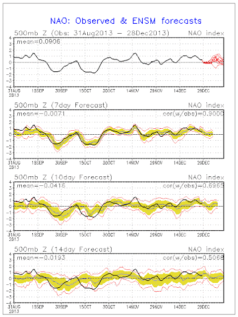
North Atlantic Oscillation going "negative" is a signal for blocking


However, most modeling is very inconclusive as to the overall impact.

At the very least, barring a complete miss (least likely option), some accumulating snow and mixed precipitation is a good bet for Thursday into Thursday night, with at least a light/moderate impact on travel.

Scenario #1 would surely be a much bigger deal, producing a major impact to travel on Thursday night. This idea, while less likely,  cannot be ruled out just yet.

Cold temperatures would provide for a quick accumulation from a powdery snow in either case.

A quick shot of very cold air will move in behind the departing storm for Friday night into Saturday morning,  regardless of the magnitude of the storm's eventual impact.  The potential is growing for lows to be in the teens and single digits for Saturday morning's low temps in NYC. A threat of near 0 degree readings for far outlying areas Saturday morning becomes even more likely with an established snow cover in place.

The overall pattern of well-below normal temperatures should continue virtually unabated through the 15th. Any let up in temps below the average (our average is around 40 for a high temp) should be on the order of 1-2 days at most, before more bitter, arctic air makes headway into the eastern states.

For example, we should see a moderation in temps for Saturday night through Monday night, before more cold air plunges in for the middle of next week, probably around the 7th or 8th.
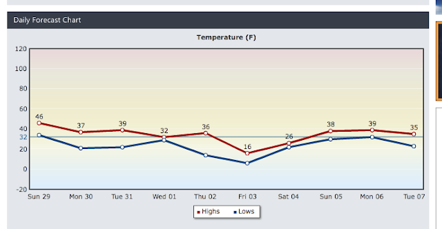
Intellicast


more later...