FULL SCREEN VERSION HERE
Friday, April 6, 2012
Thursday, April 5, 2012
OVERVIEW PREVIEW: GOOD CONSENSUS THAT SUMMER-LIKE WARMTH WON'T RETURN NEXT 7 DAYS
After a delightful Easter weekend, temps look to be near-to-below normal levels next week, with temps in the 50s. Most sources are converging on this scenario:
Accuweather Temps:
With Intellicast looking similar, with the warmest day Monday:
Joe Lundberg thinks that the coolest days are Wednesday and Thursday, and the graphics support this as well.
BUT notice that both graphics point towards significant warmth showing up by the weekend of the 14th, which is evident on the GFS today. This image is valid for next Saturday, and it would imply temps back in to the 60s:
There's an outside chance that a storm tries to develop on the coast and give us rain mid week, according to Weatherbell. But NOAA is going with a "persistence" forecast; any rainfall, they say, won't be enough to dent the dry spell. Hard to argue with them with the way things have been going, and also with the "threats" that never seem to materialize.
The overview will come out this weekend to try and hone in on the precip chances, but the temp probabilities look more certain.
Wednesday, April 4, 2012
ACCUWEATHER'S 25-DAY FORECAST (YEAH, YOU READ IT RIGHT)
Accuweather rolled out their new 25-day forecast today
So let's take a look at their temp chart (which looks like their competitor's -- Intellicast -- which I often use here and on the overviews) and see what to conclude...Then, we'll track how they do!
Here's the conclusion i reached:
After above normal temp through the weekend, a dip in temps will take place, leaving us with a chilly week next week, with temps in the low-mid 50s (which is below normal) through the 15th. Most nights are near 40 for nighttime lows next week, which is basically normal. After the 15th, a warmer week ensues the week of the 16th, before we reverse and head back towards below normal for high temps for the end of the forecast period.
what are your thoughts on the new experimental 25 day forecast?
Tuesday, April 3, 2012
FUN WITH THE CURRENT SURFACE CHART (OK I'M BORED!)
If the clouds weren't around tonight, some places in PA and NY state could have gotten really cold, as a clear sky would promote good radiational cooling:
Instead, temps will stay in the upper 40s in NY/PA
As for us, we have some chilly nights coming up, as temps will drop into the lower 40s. By Saturday night however, things will warm back up at night, so that you'll notice it (still will need a jacket)
Instead, temps will stay in the upper 40s in NY/PA
As for us, we have some chilly nights coming up, as temps will drop into the lower 40s. By Saturday night however, things will warm back up at night, so that you'll notice it (still will need a jacket)
Monday, April 2, 2012
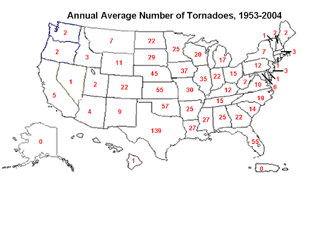
NWS TORNADO CHART YEAR -TO- DATE
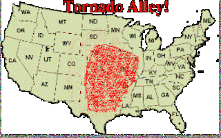
Our "big" months around here are in the late spring, which are nothing compared to the mid-west and tornado alley.
But i thought i'd re-show this anyway.
And Accuweather's story on the results
USA today provided a story and the following graphics:
strange how there seems to be a peak upward in the frequency of tornadoes once you get to eastern Connecticut and Central Massachusetts. I wonder if it has to do with the terrain or the fact that intense thunderstorms can escape being disrupted by the ocean air just enough to allow for more than the usual mayhem up in central New England. Just last June, we had a swarm of tornadoes hit central and eastern MA, and it led to some fatalities.
June 1, 2011:
Sunday, April 1, 2012
IS THE EASTER STORM THREAT ON THE WANE?
I think so
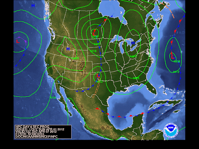
Here's NOAA's long-range weather map for this coming Saturday showing the storm well to our south. This wouldn't even be close if this verifies:
The depiction from NOAA closely resembles the GFS model seen here for the period on Friday, the day before (Good Friday). The upper right hand panel shows the storm off of Charleston, SC:
The boys at Upton are still leaving the door open for the storm for Friday into Saturday. Meanwhile, our neighboring office (and a fine one at that) in the Philly Weather Service is leaving the forecast dry, and they mention that the International model suite has the same solution as the American (GFS) model suite at this time.
All in all, the trend for no storm at all continues, but it still bares watching...
more later...
Subscribe to:
Posts (Atom)


