Saturday, December 29, 2012
12/29/12 final snowfall map
for a fairly minor storm, this appeared to be a tough forecast. The track of the storm changed from an offshore one to that which was a bit closer to the coast. Adjustment to the west allowed for heavier precip to fall (which it will with liquid amounts near .50), but it also will allow milder air to penetrate the coastal plain. Much of the Island is out of the question for the three inch amounts, but they might receive a coating on the back end of the storm, once colder air is able to filter back in from the west. So overall, not a bad call, but could have been better.
The end of the week cold air mass is not to be trifled with. It looks like bitter arctic air will make its first real push into the region, with perhaps some snowflakes around the time of the ball drop. The intellicast graphic for temps this week will take a beating; below is the old graph versus the new one, and there's no question that this is looking a lot colder for Tuesday and beyond.
OLD INTELLICAST FROM THURSDAY
NEW INTELLICAST:
OUCH! We don't get out of the 20s for high temps for Thursday and Friday. Night time lows (especially in the snow covered areas) will hit single-digit territory for one of these night as well.
Friday, December 28, 2012
Thursday, December 27, 2012
LIGHT SNOWFALL LIKELY FOR SATURDAY INTO SATURDAY NIGHT
PREDICTABILITY OF FORECAST PERIOD: MEDIUM
The first accumulating snowfall is looking likely for NYC for the true winter season.
Recall that we actually saw a decent accumulation ( and record snows for the date) but back on November 7th.
Areas nearest to the coast will get the most snow, as the storm system responsible for it will be far enough offshore to spare the region of a major winter storm.
Cold, blustery weather will take hold, with yet another storm around Tuesday or Wednesday of next week to watch out for.
Temps may plummet to their lowest levels of the winter by next Thursday and Friday.
The first accumulating snowfall is looking likely for NYC for the true winter season.
Recall that we actually saw a decent accumulation ( and record snows for the date) but back on November 7th.
Areas nearest to the coast will get the most snow, as the storm system responsible for it will be far enough offshore to spare the region of a major winter storm.
 |
| KG- using accuweather/NOAA blend |
Cold, blustery weather will take hold, with yet another storm around Tuesday or Wednesday of next week to watch out for.
 |
| Intellicast |
Temps may plummet to their lowest levels of the winter by next Thursday and Friday.
Monday, December 24, 2012
TWO MAJOR COASTAL STORMS THIS WEEK
PREDICTABILITY OF FORECAST PERIOD THROUGH TUES EVE: HIGH
PREDICTABILITY OF FORECAST PERIOD WED THROUGH SUN-MEDIUM
Lets take them one at a time. Get use to this the next couple of weeks
CHRISTMAS EVE: Light precip (mostly rain at the coast) with a dusting-2" inland from 4pm-midnight. Dry, but chilly Christmas day, cold at night.
ACCUWEATHER OLD MAP
ACCUWEATHER NEWER MAP (VERY SIMILAR)
NOAA
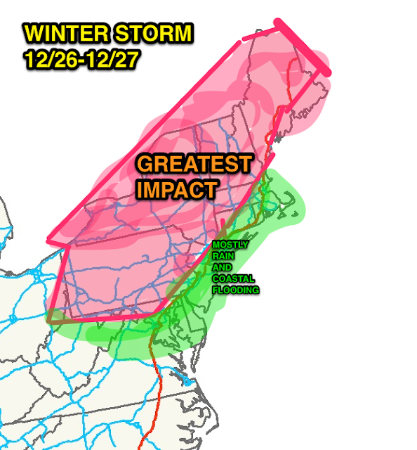
WEDNESDAY AFTERNOON INTO THURSDAY AFTERNOON: Heavy rain/strong winds near the coast, with mixed precip/ice inland. High potential for coastal flooding. Heaviest snows well inland, with upwards of a foot in the pure snow-zone, up to half that amount in the "mix" zones. Coast stays wet, while inland and points north are white. Windy conditions will persist into early Friday morning.
ACCUWEATHER
Intellicast temps:
SATURDAY INTO EARLY SUNDAY: Potential increasing for another winter storm. Strong shot of cold air arrive for New Years' Eve/Day, with arctic air mass enveloping the region.
PREDICTABILITY OF FORECAST PERIOD WED THROUGH SUN-MEDIUM
Lets take them one at a time. Get use to this the next couple of weeks
CHRISTMAS EVE: Light precip (mostly rain at the coast) with a dusting-2" inland from 4pm-midnight. Dry, but chilly Christmas day, cold at night.
ACCUWEATHER OLD MAP
ACCUWEATHER NEWER MAP (VERY SIMILAR)
NOAA
WEDNESDAY AFTERNOON INTO THURSDAY AFTERNOON: Heavy rain/strong winds near the coast, with mixed precip/ice inland. High potential for coastal flooding. Heaviest snows well inland, with upwards of a foot in the pure snow-zone, up to half that amount in the "mix" zones. Coast stays wet, while inland and points north are white. Windy conditions will persist into early Friday morning.
 |
| KG's Opinion |
ACCUWEATHER
Intellicast temps:
SATURDAY INTO EARLY SUNDAY: Potential increasing for another winter storm. Strong shot of cold air arrive for New Years' Eve/Day, with arctic air mass enveloping the region.
 |
| CPC.NOAA.GOV |
 |
| CPC.NOAA.GOV |
Subscribe to:
Posts (Atom)


