Wednesday, January 20, 2016

SEVERE SNOWSTORM TAKING SHAPE FOR LATE FRIDAY NIGHT THROUGH SUNDAY MORNING

**NEW JERSEY WILL BE EPICENTER OF MAJOR COASTAL FLOODING ON SATURDAY **

The weekend powerhouse storm is coming into focus. Heaviest snowfall accumulation look to be confined to the coast, with lesser amounts the further north and west you head. In fact, the bust potential is fairly high for areas north of Rockland and Westchester counties. 

 Further south, over the Mid-Atlantic states, snowfall may reach record-setting territory

Snow looks to spread into the metro area around daybreak Saturday and become heavy at times by mid-to-late morning. Blizzard conditions should develop for a time on the coast due to strong northeast winds and heavy snowfall. The likelihood of blizzard conditions is highest in the afternoon and evening, particularly along the coast. Travel may become impossible Saturday night. 


The snowfall idea shown here is a blend of the available guidance, Steven Dimartino Joe Cioffi and ideas of storm type from Joe Bastardi. The storm's structure and genre has striking similarities to the Blizzard of February 10/11 1983. 

Northeast Snowstorms: Volume II (Kocin/Uccellini)

Coastal flooding will be a huge problem, particularly for the New Jersey coast; tides and water levels may exceed some of the highest recorded levels since the 1940s. 

Another update will be necessary tomorrow afternoon or tomorrow night...


Tuesday, January 19, 2016

WEEKEND WINTER STORM SCENARIOS


A strong winter storm will begin to intensify over the southern states and track towards the area on Friday. The storm will bring copious amounts of Gulf and Atlantic moisture with it on its journey up the coast during the weekend.

Position of storm as of 10am Tuesday 1/19/16
Stubborn high pressure to the north of the storm will lock in sufficient amounts of cold air, making for most, if not all of the precipitation to be in the form of snow for the entire area. However, the aforementioned high  may be strong enough to keep the heaviest snows to our south, resulting in only moderate-sized snowfall totals.

 In many ways, the evolution of this storm resembles some of the more nefarious types of winter storms we've seen over the last 20 years on the eastern seaboard.

TIMING: The biggest impact to the region will be on Saturday, with slowly improving conditions on Sunday as the storm pulls away early in the day. Light snow should begin from south to north during late Friday evening and become heavy at times by Saturday morning.

IMPACTS: It's still uncertain which areas will receive the highest snowfall totals, but we should know by tomorrow night and especially Thursday.

Coastal flooding will be a huge problem. If the bulk of the snow misses to the south, this storm could still be remembered as one which brought tidal flooding and significant beach erosion. This storm will coincide with a full moon; expect moderate to major coastal flooding at the times of highest tides.


Winds will be very strong along the coast. Wind speeds could exceed 50mph on Saturday and Saturday night regardless of who gets the heaviest snowfall.


In short, this is a potentially disruptive and dangerous storm, but the exact snowfall amounts are still highly uncertain. The coastal flooding impacts should not be overlooked in any way. In addition, the storm will have far-reaching affects; those traveling over the weekend should consider leaving early if possible to avoid any complications.

 Stay tuned.

SCENARIO #1: Major blizzard with coastal flooding. 1-2 foot accumulations for the entire area.

SCENARIO #2: Bulk of the snow remains to the south of the immediate metro area, but significant coastal flooding occurs with strong winds. Moderate snowfall accumulations.

Accumulation ideas will be out by Thursday the latest.


Thursday, January 14, 2016

HIGHLIGHTS THROUGH NEXT WEEK

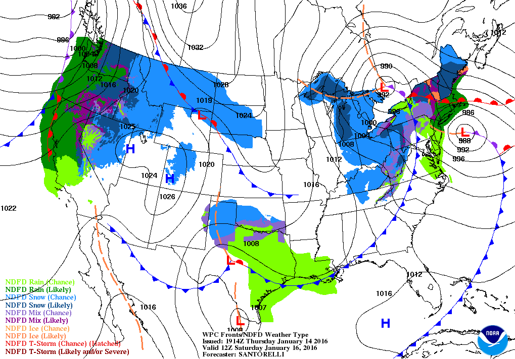
1. Coastal storm brushes the region late Friday night/Saturday with all rain.  Rain ends by early afternoon Saturday. Some flurries may fly Saturday afternoon as the storm pulls away.


WPC: Projected position of storm 7am Sat


2. Dry Sunday, with temps in the 30s. Strong cold front comes through Sunday night, with perhaps some light snow.  Windy on Sunday night.


3. Dry, but cold Monday through Wednesday. Bitter wind-chill values Monday due to gusty northwest winds. Teens for low temps both Monday night and Tuesday night. Temps slowly moderate by late week.

Hurricane Alex headed for the Azores 

Wednesday, January 13, 2016

TWO STORMS TO TRACK THROUGH MONDAY

The ideas for Friday night into Saturday's storm are pretty much on track from the earlier post. Rain becomes likely late Friday night through Saturday afternoon, with a period of moderate rain overnight Friday/Saturday morning. Total rainfall should average around 0.50 to 1 inch, with lesser amounts north and west.  As mentioned previously,  cold air, which is entrenched now, will give way to the oncoming storm as it approaches from the south.  A stubborn high pressure needs to hold its ground in order for the region to get a winter storm, but in this case, the high will push off the coast and allow warm air to flood the mid and North Atlantic states .

Tropical Tidbits: 18z GFS 1/13/15
Meanwhile, during Saturday, a new storm should take shape over the southern plains. The storm's interaction with the northern branch of the jet stream will be critical to our weather for Sunday night into Monday.  If the two entities stay separate, our weather would be blustery and cold to open the new week; however, should they merge, we would have a chance at accumulating snow for Sunday night into Monday.

7online.com/weather
One thing's for certain: Next week looks cold, with highs struggling to get out of the 20s from Monday through Wednesday. A moderating temperature trend should occur by late next week, but more storm chances will come with it.


Monday, January 11, 2016

WEEKEND COASTAL STORM THREAT

1. Weak storm system shuffles through the region on Tuesday afternoon and evening. Mainly light rain/snow for NYC and points south and east during the late afternoon through the evening hours before ending.  Windy conditions Tuesday. Across the Lower Hudson Valley and Connecticut (especially in the hilly terrain),  all snow is likely, with generally less than 2 inches of accumulation for the entire storm. Temps in the 40s Tuesday, then much cooler for Wednesday.

HudsonValleyWeather.com
2. Cool conditions persist from Wednesday through the end of the week. Wednesday is the coldest day of the week; highs in the 30s and strong northwest winds will make it feel like it's in the 20s and teens most of the day.


3. Cold air retreats as a potent storm pulls up the coast. Rain should develop from south to north Friday night and continue into Saturday afternoon before ending. A period of freezing rain is possible well inland before rain takes over Saturday.  Another update will come Wednesday to address this.

4. Turning sharply colder for Sunday and MLK Day. Temps in the 30s .


Thursday, December 31, 2015

JANUARY 1-15 OVERVIEW; COLD AND STORMY


Last January got off to a slow start. In fact, the over-hyped blizzard which started it all,  did not rear its ugly head until the 25th. This year however, we look to be facing a month in which cold and storm threats show up earlier, with the emphasis on the first half of the month. Thereafter, a pullback of sorts should ensue, before another active period of weather sets up for late January into much of February.

The temperature forecast for Monday through Wednesday is problematic. The forecasted high and low temps are not catching up to reality in some circles;  with a direct discharge of Arctic air, we should struggle to get out of the 20s on Tuesday, with low temps in the teens for Wednesday morning!


more later....