Monday, December 16, 2013

UPCOMING WEEKEND STORM WILL BE WET, NOT WHITE...

1. Snow develops tomorrow morning between 6-9AM and continues for much of the day. A general 2-4” is likely before the snow dissipates between 4-6pm. Highs will hover near 30 under cloudy skies. Clearing late. Rain should mix with snow in south shore communities, which will hold down accumulations there.


2. Fair and dry Wednesday and Thursday. Temps start to become much warmer by weeks end.
 

Intellicast


3. Mild, but wet weekend looking likely this weekend. Moist southerly flow combined with small-scale storm systems will trigger rain starting Friday, but particularly Saturday. Best weekend day is Sunday, with clearing skies and temps returning to near normal levels.

Accuweather.com

4.  Christmas Day temps look cold, but not overpoweringly so for this time of year.  No sign of any rain/snow chances yet in the long term beyond this weekend. 


Wednesday, December 11, 2013

PRELIMINARY WINTER STORM IDEA FOR SATURDAY


The question that still needs to be ironed out for the upcoming weekend storm are as follows:
a). How strong will the storm be?  A stronger storm would tend to drive warmer air up the coastal plain and make for more of a mixed precip event for the city and coast. However, a weaker storm would actually mean MORE SNOW for the coast; in this scenario, warm air would not get here in time to change the precip over to a mix. And with cold air in place, it would be able to hold on for the duration of the storm.

Ironically, the opposite effect would take place further away from the coast. Well inland, the strong storm option would crush the Hudson Valley and points to the north, as copious amounts of moisture would be thrown up into the higher elevations, with very little changeover to plain rain. However, a weaker storm would be robbed of moisture, thus only giving the region to the north of the coast a light to moderate storm...

Having fun yet...?

More later


Sunday, December 8, 2013

A WINTRY WEEK OF WEATHER IN THE MAKING...

An active, cold wintry pattern has established itself over the norther tier of states. As a result, the region is primed for bouts of light to perhaps moderate snowfalls as well as significant cold, even by December standards.

Current Snow Cover


On Tuesday,  a storm system will brush the region with a light snowfall, particularly for the city band coast. Timing looks to be in the afternoon.

My thinking...Not an official forecast...

By late week, attention will shift toward how long and how strong a bitterly cold air mass will affect the region.

Intellicast


 Temps will likely stay below freezing during the day beginning on Thursday and into Friday.

The weekend is problematic. There is some concern for potentially extreme cold by the weekend, but more than the usual amount of uncertainty exists.

Another shot at snowfall will come late this weekend and early next week, as a storm makes a move out of the southern plains states towards the east coast.

Frequent updates will be necessary this week...

Tuesday, December 3, 2013

ACTIVE WEATHER PATTERN SHAPING UP FOR DECEMBER

The stretch of benign weather with very little precipitation over the last few months is now transitioning to a more stormy. active picture overall. The presence of both very bitter arctic air over the Canadian Prairies (bolstered by a healthy snow cover over our neighbor to our north), as well as the typical strengthening of the jet stream, should spell lots of opportunities for rain and eventually frozen precip types as we move deeper into the month. This is in contrast to last December already; chances for storms didn't materialize until the last ten days of the month, and few of them managed to bring any wintry weather. But with the extreme contrast in air masses this month, we should look for a combination of wild temp swings (which we've seen already) and generally speaking, an uptick in storminess.

HIGHLIGHTS:

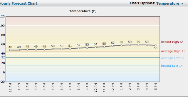
Wednesday night/Thursday: Widespread drizzle and fog should develop ahead of the warm front and continue through the morning.  Light rain and drizzle should scour out in the afternoon Thursday, with very mild temps. Readings many top 60 in the normally warmer spots around the region, even in NYC.
Intellicast
Intellicast: Hourly Temp Forecast for December 5 (Thursday)


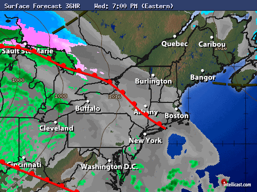
Thursday Night/Friday: Steadier rains develop late at night and should persist through much of Friday and Friday night. Up to an inch of liquid is expected with this front. Rain will transition to snow and sleet well north and west of the city and coast Friday night, so that extreme northwestern New Jersey could pick up a light accumulation late Friday night into early Saturday morning before precip ends everywhere.

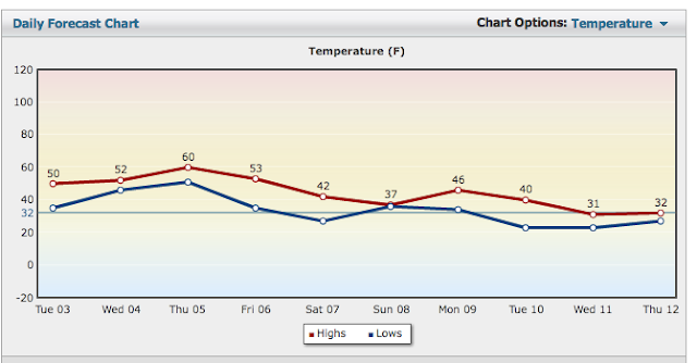
On Friday morning, it's still quite mild! However, temps will tumble steadily through the daytime hours and through the night Friday night as the winds shift to the northwest.
Intellicast 7-Day Temp Forecast


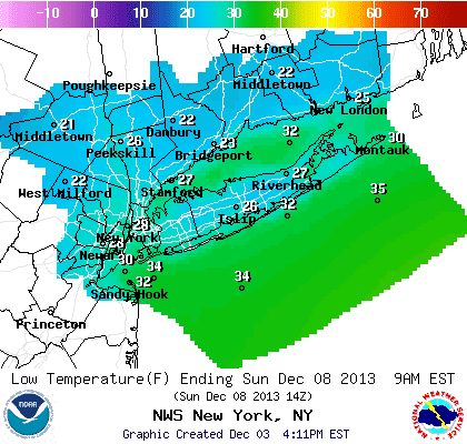
Saturday: Best looking day of the weekend, but we're cold again. Saturday night looks quite chilly.
NOAA Lows Saturday Night


Sunday-Tuesday: Complex series of storms will move through.

Potential for a wintry mix for all areas for at least a few hours during the afternoon, eventually becoming  rain at the coast and in the city for Sunday night into Monday. As you head well away front the city and coast, it's more of a wintry mix scenario. This will need fine tuning.

Another storm may follow in behind for Tuesday into Tuesday night.