Thursday, May 2, 2013

Sunday, April 28, 2013
MAY SHOULD START MOSTLY MERRY
1. Weakening storm will brush the western parts of the area (including NYC) Monday into Tuesday, with pesky light rain. Temps will stay near 60, but the area will be cloudy until Tuesday afternoon/night. Clouds will clear in unusual fashion Tuesday -- from east to west -- as a blocking pattern establishes itself.


2. Said pattern will lead to light easterly flow off of the relatively cool ocean. This will keep temps in the lower 60s through the week. The further east you head, the more likely it is that temps will be even a tad lower.
3. Thursday/Friday: Our warmest days, but then a slow-moving storm approaches for late in the weekend, which could knock our temps down and offer increasing rain chances.
4. Periods of extended warmth are unlikely going further into May. Pattern is bottled up. Blocking high over the Northeast as opposed to our south will promote a strong Maritime influence on our temps. Slow-moving storms as well as the position of the blocking high will keep temps from running too far ahead of schedule.


2. Said pattern will lead to light easterly flow off of the relatively cool ocean. This will keep temps in the lower 60s through the week. The further east you head, the more likely it is that temps will be even a tad lower.
3. Thursday/Friday: Our warmest days, but then a slow-moving storm approaches for late in the weekend, which could knock our temps down and offer increasing rain chances.
 |
| Intellicast |
 |
| Accuweather.com |
Wednesday, April 24, 2013
TOP FIVE DRIEST APRIL LOOKING LIKELY FOR NYC...
After a weakening area of showers moves through late this evening into the overnight, the weather will be very tranquil through the weekend and much of next week. A stray shower could pop up Sunday night or Monday night, but the potential is VERY low at this time for this to transpire.
As it stands now, the park only has 1.27 of rain for the entire month; the prospects of little to no rainfall the next seven days all but assures that NYC will make the record books for dry Aprils since record keeping began in 1869.

So while in the Mid-West, where it's too wet to plant, we have the opposite problem!
The pattern could turn wet, cool and stormy again in the first full week of May, as a cool pocket aloft may try to churn up a coastal storm.
But until then, at least the next 7 days and probably beyond, spring is in full swing, which should make a lot of people's hearts sing.
As it stands now, the park only has 1.27 of rain for the entire month; the prospects of little to no rainfall the next seven days all but assures that NYC will make the record books for dry Aprils since record keeping began in 1869.

So while in the Mid-West, where it's too wet to plant, we have the opposite problem!
 |
| WPC 7-day total precip shows between .01-.10 for the area through next Thursday 5/2/13 |
The pattern could turn wet, cool and stormy again in the first full week of May, as a cool pocket aloft may try to churn up a coastal storm.
But until then, at least the next 7 days and probably beyond, spring is in full swing, which should make a lot of people's hearts sing.
 |
| Intellicast |
Sunday, April 21, 2013
WEATHER ROUND-UP FOR THE UPCOMING WEEK
The week will start off on a cool, breezy note, as clouds and moisture build for Monday into Tuesday. Temps will be held in check, so that readings remain below their typical mid-April levels; highs will stay in the 50s for all areas through Tuesday.
A storm system will track to our south and east, with the best shot at light rainfall Monday night into Tuesday. Overall though, the bulk of the precip will stay off-shore and most areas will see little to no rainfall. The best chances for rain would be for the far southern and easternmost portions of the region.
 |
| NOAA: Threat of frost tonight in areas in blue |
A storm system will track to our south and east, with the best shot at light rainfall Monday night into Tuesday. Overall though, the bulk of the precip will stay off-shore and most areas will see little to no rainfall. The best chances for rain would be for the far southern and easternmost portions of the region.
 |
| WPC Forecast for 7am Tuesday shows the storm well south of NYC
Wednesday is dry, sunny and a bit breezy; it should be our warmest day of the week. A quick shot of rain and some thunderstorms moves in at night into the overnight; this will give way to a stray leftover shower and slow clearing for Thursday into Thursday night. Most of Thursday should be dry for NYC and points to the north and west.
There can be a stray afternoon shower on Friday, but overall, the pattern the next seven days is a fairly dry one! Temps should hover around normal levels over the weekend, with Sunday being slightly warmer than Saturday. Some clouds should arrive by Sunday afternoon, with even a few showers advancing in at night Sunday night. Intellicast Temps:  |
Wednesday, April 17, 2013
Monday, April 15, 2013
THE WEEK AHEAD: MILD EAST, COOL WEST
1. The folly of MLB early season scheduling will be on display yet again this week. Just as the Yankees were postponed due to cold in Cleveland this past week, the Mets will endure the same fate; at least two games in Denver will be snowed out this week!
2. On our side of the coin, it's mild and dry through late week! The coastal areas will feel a cool breeze in the afternoons.
3. Pretty decent chances for early morning fog starting on Tuesday and increasing in coverage and thickness for Wednesday and Thursday mornings. Dense fog a good bet Thursday morning; this may have trouble burning off, so that temps could run a few degrees cooler than forecasted near the coast.

4. Friday: High probability of widespread rainfall and thunderstorms at night, as moist southerly flow meets an incoming cold front. Potential is greater for heavy downpours than that of severe weather at this time, but it needs to be watched. Clearing for the weekend. Temps will be near 60, with leftover clouds eventually being scoured out Saturday morning.
5. Cooler next week, with a chance of another storm around the 24th.
6. The Cicada invasion may start anew this summer! Beware!
2. On our side of the coin, it's mild and dry through late week! The coastal areas will feel a cool breeze in the afternoons.
 |
| intellicast |
3. Pretty decent chances for early morning fog starting on Tuesday and increasing in coverage and thickness for Wednesday and Thursday mornings. Dense fog a good bet Thursday morning; this may have trouble burning off, so that temps could run a few degrees cooler than forecasted near the coast.

4. Friday: High probability of widespread rainfall and thunderstorms at night, as moist southerly flow meets an incoming cold front. Potential is greater for heavy downpours than that of severe weather at this time, but it needs to be watched. Clearing for the weekend. Temps will be near 60, with leftover clouds eventually being scoured out Saturday morning.
5. Cooler next week, with a chance of another storm around the 24th.
6. The Cicada invasion may start anew this summer! Beware!
Tuesday, April 9, 2013
TIMING THE RAIN THE NEXT 72 HOURS...
First, temps surpassed the expectations from the weekend for today's actual readings; in fact, records were shattered at a few locales...
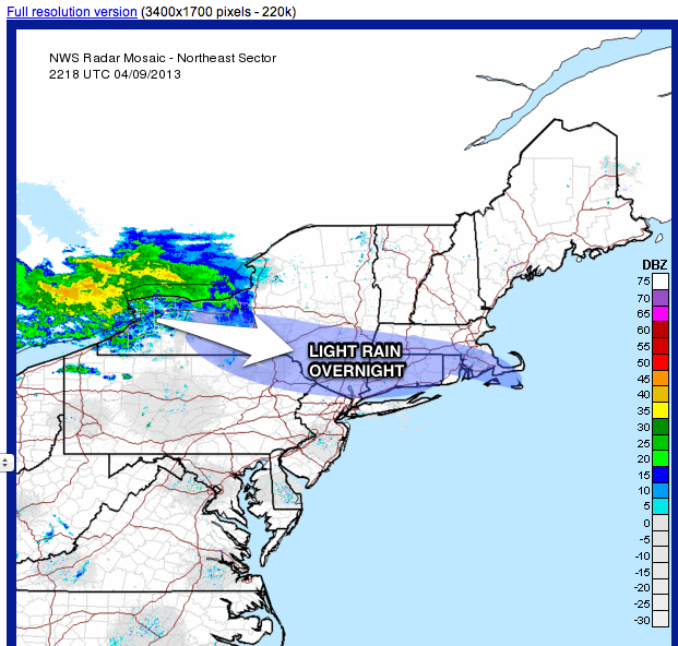
A few showers could sneak in overnight, especially north and west of the city.
The spring/early summer temp spike will finish up tomorrow, with many areas in NYC in the mid-70s yet again.
The front which has caused a lot of forecaster consternation this week will advance in late day tomorrow, sparking some thunderstorms from NYC north and west (including most of New Jersey).
Leftover showers and clouds will eventually spill into the coastal sections at night, with fog developing late tomorrow night into Thursday. Thunderstorms are not as likely near the coast, as the marine influence will tend to weaken anything that comes from the north and west.
Raw, chilly conditions will persist into thursday and Friday. it will be a rude shock with temps struggling to get to 50 on the coast, with only lower to mid 50s in the warmer urban spots.
Rainfall will be rather spotty and drizzly through much of Thursday, but then steady rainfall takes shape for early Friday morning into much of Friday afternoon before ending Friday evening. A good soaking is in store area-wide, with most places easily picking up near an inch of precip by the time it winds down Friday evening.
A dry, pleasant weekend follows, with slowly moderating temps to above-normal through early next week.
 |
| NOAA |
A few showers could sneak in overnight, especially north and west of the city.

The spring/early summer temp spike will finish up tomorrow, with many areas in NYC in the mid-70s yet again.
The front which has caused a lot of forecaster consternation this week will advance in late day tomorrow, sparking some thunderstorms from NYC north and west (including most of New Jersey).
 |
| Accu-weather |
Leftover showers and clouds will eventually spill into the coastal sections at night, with fog developing late tomorrow night into Thursday. Thunderstorms are not as likely near the coast, as the marine influence will tend to weaken anything that comes from the north and west.
Raw, chilly conditions will persist into thursday and Friday. it will be a rude shock with temps struggling to get to 50 on the coast, with only lower to mid 50s in the warmer urban spots.
Rainfall will be rather spotty and drizzly through much of Thursday, but then steady rainfall takes shape for early Friday morning into much of Friday afternoon before ending Friday evening. A good soaking is in store area-wide, with most places easily picking up near an inch of precip by the time it winds down Friday evening.
A dry, pleasant weekend follows, with slowly moderating temps to above-normal through early next week.
 |
| Intellicast |
Subscribe to:
Posts (Atom)