A potentially active day is shaping up for storms today. The pink areas are where a "severe thunderstorm watch" is in effect until 11pm. The orange areas denote some active warnings. You can visit the NOAA site for updates on current warnings
Overall this week is shaping up to be unsettled. The storm coverage will be less tomorrow and we'll get a break on Wednesday altogether. However, as pointed out in the last overview, the weather picture gets unsettled again for Thursday-Saturday. And although it won't rain the entire period, the odds are fairly high that we will have to dodge some periods of heavy rain and thunderstorms.
more later
Monday, July 23, 2012
Sunday, July 22, 2012
LATE WEEK LOOKS UNSETTLED THIS WEEK.
PREDICTABILITY OF FORECAST PERIOD THROUGH WEDNESDAY-High
PREDICTABILITY OF FORECAST PERIOD THURSDAY-SUNDAY-Low
1. Huge bust temp-wise this past friday, as high did not make it out of the mid 60s!! Overview and most other sources caught off-guard by the rare July chill.
2. Sunday night (tonight) through Monday night: A risk of a thunderstorm. Northern areas have the biggest risk early in the period, then more of a risk tomorrow afternoon NYC/points south and east. Storms will not be incredibly strong. highs near 90.
NOAA Precip chart shows a peak "chance" for 7pm Monday, with lesser "chance" before and after
3. Tuesday is the hottest day of the week, with highs in the low to mid 90s. Risk of a thunderstorm Tuesday afternoon/evening as a strong front pushes out the scorching air mass by Tuesday night.
Intellicast Temps:
4. Dry/seasonable temps Wednesday, then things get unsettled Thursday-Saturday, with numerous showers/thunderstorms possible all areas. Timing and placement of rainfall very uncertain. Update will be needed to address the period.
5. Back-and forth temp pattern next 10 days, with no signs of prolonged heat spells of more than a day or two. The period from June 20-July 20 could stand out as the hottest point of the summer for our region, with a noticeable relaxation after 7/20 (but only time will tell if this is correct).
Intellicast Temps next 6-10 days shows this balancing out to a "normal" stretch of summer weather:
PREDICTABILITY OF FORECAST PERIOD THURSDAY-SUNDAY-Low
1. Huge bust temp-wise this past friday, as high did not make it out of the mid 60s!! Overview and most other sources caught off-guard by the rare July chill.
2. Sunday night (tonight) through Monday night: A risk of a thunderstorm. Northern areas have the biggest risk early in the period, then more of a risk tomorrow afternoon NYC/points south and east. Storms will not be incredibly strong. highs near 90.
NOAA Precip chart shows a peak "chance" for 7pm Monday, with lesser "chance" before and after
3. Tuesday is the hottest day of the week, with highs in the low to mid 90s. Risk of a thunderstorm Tuesday afternoon/evening as a strong front pushes out the scorching air mass by Tuesday night.
Intellicast Temps:
4. Dry/seasonable temps Wednesday, then things get unsettled Thursday-Saturday, with numerous showers/thunderstorms possible all areas. Timing and placement of rainfall very uncertain. Update will be needed to address the period.
5. Back-and forth temp pattern next 10 days, with no signs of prolonged heat spells of more than a day or two. The period from June 20-July 20 could stand out as the hottest point of the summer for our region, with a noticeable relaxation after 7/20 (but only time will tell if this is correct).
Intellicast Temps next 6-10 days shows this balancing out to a "normal" stretch of summer weather:
Thursday, July 19, 2012
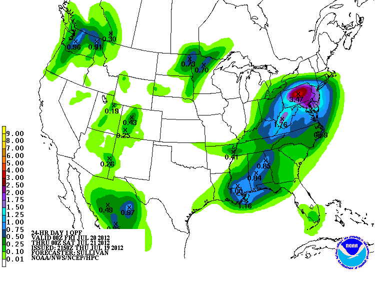
NEW JERSEY THE TARGET FOR HEAVY RAINS NEXT 24-48 HOURS...
for much of the region, a soaking rainfall will commence late tonight and continue through early Saturday morning, before tapering off. Although much of the weekend will be rain-free, the storm for Friday is looking more robust, and thus, it constituted an update here.
We'll use NOAA's map to decipher where the heaviest rains will fall overall. In the shaded tan areas, 1 to as much as 3 inches can fall, with even some flash flooding at times.
For NYC and points to the east, the total rainfall amount will lessen as you head east, yet many areas (except for far eastern Long Island and Connecticut) will see around or just over an inch. This is depicted nicely by NOAA's HPC graphic, showing the core of heaviest rains in red, purple and pink.
We'll use NOAA's map to decipher where the heaviest rains will fall overall. In the shaded tan areas, 1 to as much as 3 inches can fall, with even some flash flooding at times.
For NYC and points to the east, the total rainfall amount will lessen as you head east, yet many areas (except for far eastern Long Island and Connecticut) will see around or just over an inch. This is depicted nicely by NOAA's HPC graphic, showing the core of heaviest rains in red, purple and pink.
Tuesday, July 17, 2012
A WEDNESDAY WALLOP WILL BREAK UP THE HEAT
PREDICTABILITY OF FORECAST PERIOD - Medium
1.Strong storms will threaten by mid afternoon (western parts first, then further east), and continue through early evening before winding down to just a risk of a shower by mid evening/late at night. Hot, with temps in the low 90s; muggy once again before the storms scour out the humidity.
INTELLICAST map shows that the heaviest showers/storms will wind down around sunset.
2. Numerous showers will continue Thursday and again Friday, both during the day. A lesser risk of a shower exists for areas east and south of NYC. Cooler, with highs in the 80s. Friday is predominantly cloudy. Humidity values low through the weekend.
3. Gorgeous weekend on tap, as comfortable summertime temps and low humidity values rule both Saturday and Sunday. Showers could creep in late Sunday/early Monday. Humidity and temps rise once again early next week, with another shot at 90 degrees or better by mid week.
4. Overall long-range pattern suggests a second consecutive east coast August tropical threat.
Thursday, July 12, 2012
BLISTERING HEAT, NO. STEAMBATH HEAT, YES
PREDICTABILITY OF FORECAST PERIOD THROUGH NEXT THURSDAY: Medium
1. Main theme the next week will be a discernible increase in humidity values the next seven days. Although not oppressively hot, the combination of very warm temps with abundant humidity will lead to an uncomfortable stretch of summertime conditions beginning Friday.
NWS TEMP/DEW POINT combo Sunday through Wednesday:
SUN/MON

TUES/WED
DEW POINT CHART shows our area in the "oppressive" category...
2. Rainfall- Best chance still appears to be Saturday night through Sunday night, with just a risk of a heavy shower/storm Saturday evening. More numerous showers/thunderstorms abound area-wide Sunday; Flash flood threat is high with any storm.
3. Temps- Near 90 each day, with low 90s common Monday-Wednesday. Only a risk of a thunderstorm exists Monday-Thursday (NOAA Idea). Hottest day is Tuesday, with highs near 95 and heat index values possibly over 100 degrees for NYC (Intellicast/Accuweather).
"weather overview" terms to help kick the point-and-click:
PREDICTABILITY OF FORECAST PERIODS
HIGH- most credible sources are in excellent agreement
MEDIUM: most credible sources are in fairly good agreement, with some differences
LOW: widespread differences in forecasts, AND overall low confidence from NWS Upton office
Risk of a shower/thunderstorm-probability of a shower is low. Most of the forecast period will be dry.Numerous (heavy can be inserted) Showers/thunderstorms- probability of showers is high, and could happen multiple times during the given forecast period. Constant rain is not expected
Rainy conditions-intermittent precip; rain can vary in duration, but usually will last more than an hour. Light to moderate intensity. Less than an inch expected during the forecast period.Heavy Rain-soaking, constant rainfall for at least an hour (duration can be much longer); amounts over a half an inch.Light snow-very light snowfall. Little to no accumulation. Duration depends.Snowy conditions-intermittent snow can last more than an hour at a time, but generally average less than 3 inches total.Heavy Snow-heavy snowfall. Snowfall of at least 3 hours in duration. Totals can be added inDrizzle-constant drizzleOccasional Drizzle-intermittent drizzle
Tuesday, July 10, 2012
Subscribe to:
Posts (Atom)