Thursday, December 17, 2015

MID-WEEK RAIN PRECEDES A DRY CHRISTMAS

1. 36-48 hour period of December chill takes shape for Friday and Saturday. Temps hit the upper 40s Friday, but highs will struggle to reach 40 on Saturday on a brisk northwest wind. Wind-chill values Saturday will be in the 20s and 30s all day; a few flurries are possible both days.


2. Short-lived chill lingers Sunday with less wind.  By Monday,  temps once again rebound to above-normal levels.  Clouds increase for Monday afternoon into Tuesday.

NOAA: Temps from 12am Sunday to 11pm Monday

NOAA: Temps from 12am Tuesday to 11pm Wednesday


3. Rain arrives early Wednesday with warm temps.  Rain continues for a 6-10 hour period on Wednesday before tapering off Wednesday night.

4.  Record highs are likely on Christmas Eve with plenty of clouds and a few showers late.  Thursday night,  a weak cold front clears the area of rain and lowers our temps for Christmas Day. Passage of aforementioned frontal boundary should dash any hopes of cracking the top 5 warmest Christmas "days" on record, but it'll be close, with high temps in the 50s.
NOAA: Warmest recorded temps for 12/25 at Central Park


5.  After this weekend, no significant cold for the remainder of the month. Much like last winter, any pattern change to cold and stormy won't come before January 10.

Saturday, December 12, 2015

WARMTH WILL DOMINATE THE WEATHER THROUGH CHRISTMAS...

1. Record warmth from this weekend will be replaced by cooler temps for Tuesday through Thursday. However, temps will still run well above normal levels from where they should be for this time of year, with highs in the lower 50s for the majority of the work week ahead. 

2. Downpours and a few thunderstorms are a good bet for Monday night into Tuesday. Expect a 6-8 hour window of rain from about 4pm onwards Monday night into early Tuesday before it clears out. The rainfall deficit will be chipped away, but only slightly from this cold frontal passage.
Tropical Tidbits: GFS forecast for 7pm Monday

@LeeGoldbergABC7 on Twitter
3. Dry for mid-week. Windy on Tuesday, with cooler temps (but still above normal).

4. Showers develop for Thursday and Thursday night. Chilly weekend settles in next weekend, with highs in the 40s. Some rain/wet snow could clip the region Friday as a storm develops off of the New England coast and heads out to sea.

7online.com/weather

5. Temps quickly rebound into "above normal" territory for Christmas week. Any shots of cold look to be transient, with storms staying confined mostly to the western states.


Sunday, December 6, 2015

ANOTHER QUIET WEEK OVERALL

The active southern storm track which is associated with El Nino continues to show prominence over the southern and western states. Subtropical moisture from the Pacific Ocean will, by and large, continue to fuel systems across the Lower-48 States.

Intellicast
However, at least for this week, the storms won't be able to turn up the coast. Rather, they will get blocked as they come up with the result being a fairly dry week for the area.

NOAA: Total precipitation through Friday


Moreover, bitter cold air remains trapped in Canada; this is due to the overall configuration of the jet stream.


As the cold intensifies over the next few weeks, the active southern storm track will ultimately lead to many opportunities for substantial winter storms; but this process will be slow to evolve.

Wednesday, December 2, 2015

WATCHING A COASTAL STORM FOR NEXT WEEK

1. After Wednesday’s rain, skies remain cloudy for a good part of Thursday before clearing late Thursday afternoon and night. Departing low pressure will leave strong gusty winds in its wake from mid-morning Thursday through much of Thursday night. Temps initially will be in the 50s during the day, but then start to fall rapidly into the 30s at night. A chilly night is on tap for Thursday night, with gusty winds.

WPC.noaa.gov


2. Winds relax on Friday as high pressure takes control. Fair weather persists for the weekend into early next week. Temps will be seasonable, with highs in the upper 40s to low 50s.

7online.com/weather


3. Low pressure will take shape early next week off the South Atlantic coast. Track of the slow-moving storm is uncertain; potential is there for a soaking rainfall accompanied by strong winds for Tuesday afternoon into Wednesday. Conversely, aforementioned strong high situated to our north may block the storm’s progress, keeping the rain to our south. Bears watching.

4. No sign of any widespread wintry weather (cold and/or snow) in the long range through mid-month. 

Wednesday, November 18, 2015

THURSDAY RAIN, BUT QUIET FOR THANKSGIVING WEEK

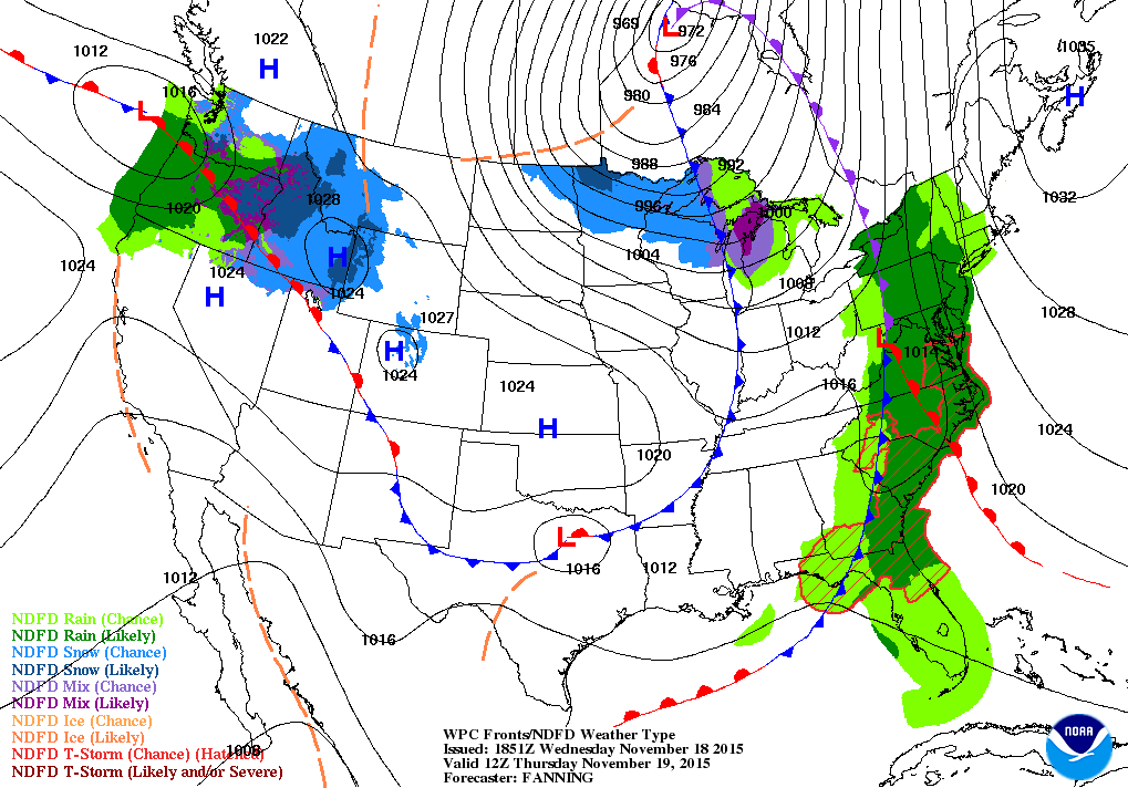
1. Rain moves into the picture after the morning rush reaches its peak. Rain will be heavy at times from late morning through the early evening before ending by late evening. It'll be breezy in the afternoon; temps will be steady under a canopy of clouds for tonight into Thursday, with clearing late Thursday night.

NOAA: rain becomes likely by mid-morning all areas


2.  Friday through the weekend is sunny. Saturday and Sunday are cool; brisk conditions for early next week, but temps slowly moderate.

7online.com/weather

3.  High pressure continues to dominate the region through much of next week, with fair skies and temps near 50 for highs.  Holiday travel in the eastern states should be good for next week, with most of the active weather confined to the western states.

4. Below normal temps likely for the beginning of December. Cold pocket of air, currently building over the Pacific Northwest States, should charge eastward late next weekend, arriving near the east coast by December 1st. Cold pattern looks transient.