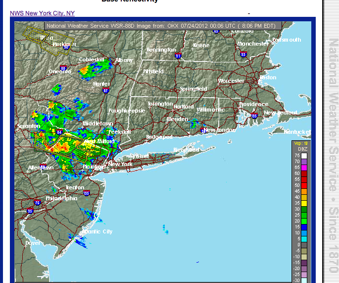
Building areas of showers and some severe thunderstorms have prompted the NWS to issue the watch.
The storms are quite heavy over coastal New Jersey, and they will continue to intensify and move across the watch area through 10pm
RADAR as of 140pm
Watch Coverage Map
Saturday, July 28, 2012
Thursday, July 26, 2012
VIDEO: LOOKING AT FRIDAY/SATURDAY STORM CHANCES
'MODERATE" RISK EXPANDED TO INCLUDE THE COAST...
The storm predictions center adjusted the moderate risk area talked about in yesterday's overview; they are now forecasting a moderate risk, even to the coast of Long Island.
stay tuned
stay tuned
Wednesday, July 25, 2012
RISK OF THUNDERSTORMS TO CONTINUE FROM FRIDAY INTO SATURDAY...
PREDICTABILITY OF FORECAST PERIOD-medium
1. Friday continues stormy, with numerous showers and thunderstorms in the afternoon and evening. Hot and humid with highs in the upper 80s/low 90s. Storms should not be as robust as Thursday's activity and a bit less organized.
2. Saturday: Storm threat confined to areas west and south of NYC, as front responsible for the Friday storms should be through most of the region. Cooler with highs in the 80s
3. Sunday's the best day this weekend, as conditions stabilize and full sun prevails.
Intellicast Temps
4. Monday-Wednesday: Humidity returns, with the risk of a shower/storm in the afternoon (especially Wednesday).
1. Friday continues stormy, with numerous showers and thunderstorms in the afternoon and evening. Hot and humid with highs in the upper 80s/low 90s. Storms should not be as robust as Thursday's activity and a bit less organized.
2. Saturday: Storm threat confined to areas west and south of NYC, as front responsible for the Friday storms should be through most of the region. Cooler with highs in the 80s
3. Sunday's the best day this weekend, as conditions stabilize and full sun prevails.
Intellicast Temps
4. Monday-Wednesday: Humidity returns, with the risk of a shower/storm in the afternoon (especially Wednesday).
"weather overview" terms to help kick the point-and-click:
PREDICTABILITY OF FORECAST PERIODS
HIGH- most credible sources are in excellent agreement
MEDIUM: most credible sources are in fairly good agreement, with some differences
LOW: widespread differences in forecasts, AND overall low confidence from NWS Upton office
Risk of a shower/thunderstorm-probability of a shower is low. Most of the forecast period will be dry.Numerous (heavy can be inserted) Showers/thunderstorms- probability of showers is high, and could happen multiple times during the given forecast period. Constant rain is not expectedRainy conditions-intermittent precip; rain can vary in duration, but usually will last more than an hour. Light to moderate intensity. Less than an inch expected during the forecast period.Heavy Rain-soaking, constant rainfall for at least an hour (duration can be much longer); amounts over a half an inch.Light snow-very light snowfall. Little to no accumulation. Duration depends.Snowy conditions-intermittent snow can last more than an hour at a time, but generally average less than 3 inches total.Heavy Snow-heavy snowfall. Snowfall of at least 3 hours in duration. Totals can be added inDrizzle-constant drizzleOccasional Drizzle-intermittent drizzle
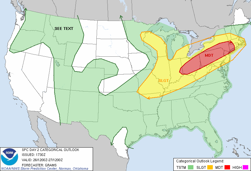
DAMAGING THUNDERSTORMS WILL THREATEN THE TRI STATE AREA THURSDAY AFTERNOON AND EVENING
PREDICTABILITY OF FORECAST PERIOD THROUGH FRIDAY-MEDIUM
A very significant severe weather outbreak in the form of thunderstorms with strong, damaging winds, appears likely to affect much of the region tomorrow afternoon.
Parts of our area are in a “moderate” risk for severe storms Thursday; this classification is usually reserved for areas of the mid-west and southern plains states during some of the most prolific episodes of severe weather year-round!
…
Tomorrow is a day to keep tuned to the latest watches and warnings from NOAA.
There is a credible threat of one or two tornadoes, particularly north and west of NYC.
Long Island is not in the moderate risk area, but they will probably not escape entirely. The fear is that the storms maintain and pose a widespread wind damage threat into the early evening, with similar potencey to the June 29th storms, which rocked the mid-west and middle Atlantic states for hundreds of miles across.
IF there’s a caveat, it would be that ongoing storms in the morning (for the Hudson valley and north) spread enough cloud cover to mitigate the main storm threat in the late afternoon. However, overall conditions appear to still be conducive for strong storms to develop, making the “escape” idea a low probability at this time.
Now is the time to prepare for the possibility of travel delays and some disruption to outdoor events for Thursday afternoon and early evening.
There will be a separate overview coming to address the period for Friday through the weekend…
stay tuned
Monday, July 23, 2012
WEAKENING SHOWERS SET TO AFFECT NYC...
Over the past several hours, clusters of showers and some heavy thunderstorms have worked their way south. but with the loss of daytime heating, and the influence of the marine layer over Long Island, storms have waned. Nevertheless, expect showers and storms to roll through the next one to two hours, with perhaps another round in the pre-dawn hours.
Some food for thought: only 4 days this month have seen over .10 of rainfall. However, due to last week's storms, and a smattering of other days before and after, NYC is near normal for the monthly total. As far as temps are concerned, NYC is 3.1 above the normal monthly mean temperature. With the prospect of late week rains, monthly departures should level off some more. Regardless, indications are that we'll finish somewhere around +2 by the time we reach the end, cementing the idea that, unlike the mostly benign June, this month was decidedly a toasty time around these parts.
Subscribe to:
Posts (Atom)