Wednesday, November 4, 2015

WEEKEND COOL-DOWN

1. Fog develops late tonight. Clouds prevail tomorrow and again on Friday, with light rain/drizzle moving in during the afternoon and at night.  Remaining very warm despite the clouds on Thursday, with highs in the 60s.

2. Another balmy November day is on tap for Friday.  Any rain should hold off until a fast-moving cold front moves through with a few showers during the evening hours. The bigger story with this front as a return to more seasonable temps for the weekend.

3. Chilly night for Sunday night/Monday, with widespread low temps in the 30s. Calm winds and no cloud cover will allow temps to bottom out area-wide.


4. Quiet for Monday, but clouds lower and thicken for Tuesday and Wednesday. Exiting high pressure to our east and nearby disturbances could trigger rain at some point in this period.

Meteorologistjoecioffi.com

5. Signs of any significant change in the weather pattern which would promote much cooler weather (like we saw last November) are elusive. Any major reconfiguration of the pattern in the Northern Hemisphere should be slow over the next week to 10 days. 

Sunday, November 1, 2015

WINTER 2015-16: ACTIVE, STORMY WINTER AHEAD WITH ABOVE-NORMAL SNOWFALL


RATIONALE: The backdrop of the upcoming winter season revolves around a strong El Nino, warm sea-surface temperatures near the east coast and in the northern Pacific Ocean, rapid expansion of Siberian snow cover and an active southern jet stream. All of the aformentioned factors will work in concert to produce an abundance of storms this year.  The phasing of the northern and southern branches of the jet stream will be critical in pinpointing exactly where the heaviest snows fall during any one particular storm. Look for a lot of variability in forecasts in the run-up to potential threats yet again this season.
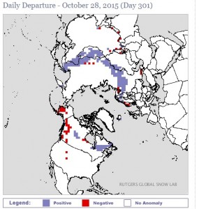
Snow cover as of 10/28/15

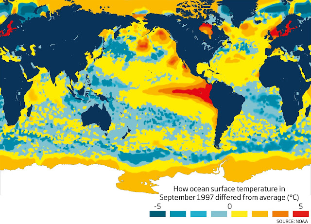
The one critical characteristic of the El Nino this year which gives us a clue to the winter, lies in Region 3.4; in short, warmer water in the Central Pacific as opposed to closer to South America, tends to favor higher snowfall totals over the Southern and Eastern states.
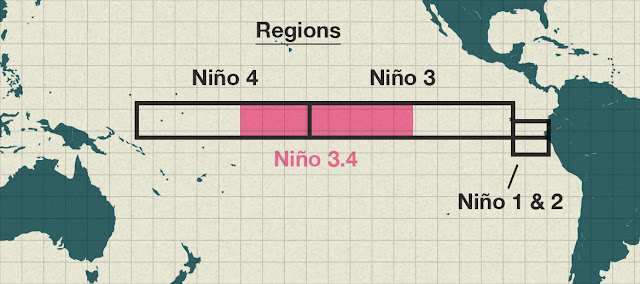
El Nino Regions


In El Nino years where the opposite is true (warmer water closer to South America in Regions 1.2 and slightly cooler water in the Central Pacific), our winters tend to be more benign, allowing for more rain chances closer to the coast and longer intrusions of mild, Pacific air.

How This El Nino Compares To The "Super-Nino" of 1997. 

Water Temps: October, 2015
Water Temps: September, 1997

Generally speaking, winters of this type ebb and flow. There will be periods of warmer weather with less storms, much like we saw from mid-December to mid-January in the last winter.

Typically, in El Nino winters, late January to late March tends to be the worst part. Examples of this would be 2009-10, 2002-03, and 2010-11.

WHAT COULD GO WRONG: Similar El Nino winters have sometimes favored a storm track further to our south. A good example of this can be found in the winter of 1986-1987, which brought record-setting snows to the Mid-Atlantic region while brushing the immediate Tri-State area and points north.  Also, as noted above, storms which involve phasing of the two branches of the jet stream could lead to inland storm tracks; an inland storm track would pull in mild air, cutting down on seasonal snowfall accumulations, particularly towards the coast.


CPC: NOAA Winter Outlook

Meteorologist Joe Cioffi's Winter Outlook

Weatherbell Winter Outlook

Steven DeMartino's Winter Outlook

THE BOTTOM LINE: Prepare for another cold, stormy season, with the emphasis on mid-to-late winter. This season should also be slow to relent much like last year.


Monday, October 26, 2015

MUCH NEEDED MID-WEEK SOAKER

A strong jet stream, a frontal zone and some tropical moisture will combine to give the region a good 1-2" of rain this week

Tropical Tidbits 


7online.com/weather


Slow clearing ensues Thursday, with a warm day on tap. However by Friday, temps return to normal levels and this should remain the case through the weekend.  Chances for rain in the form of showers arrive on Sunday, but amounts should be light.

Daylight savings time ends Sunday. Turn your clocks back one hour on Sunday morning.

Thursday, October 22, 2015

WATCHING FOR BENEFICIAL RAINS MID-WEEK NEXT WEEK

Very quiet weather is in store for the region through Tuesday. However, a series of weak cold fronts will knock our temps down to more seasonable levels;  beginning on Friday, 70s will be replaced by 60s for highs through next week.

The aforementioned frontal systems will spark light rain late Saturday night into early Sunday. It'll be damp, but rainfall amounts will be paltry.

WPC: Weather map for 7pm Saturday

By Wednesday, another front will move towards the region. This weather system could have some connection with tropical moisture as it moves through; the result should lead to a soaking rainfall for Wednesday night into Thursday morning.


Even cooler weather moves in behind the mid-week rains, setting up a chilly backdrop for Halloween and the World Series next weekend.

Sunday, October 18, 2015

QUIET LATE-OCTOBER WEATHER THIS WEEK

http://wxmaps.org/pix/avnmr.vort.html


After the freezing temps of Monday morning, the mercury will steadily rise all week, which will lead to near-normal temperatures.

NOAA: Forecasted low temps for Sunday night/Monday Morning


Rain chances will be futile this week in alleviating the dry conditions we've experienced through the past several months. We could see a passing light shower Tuesday night and during the day Wednesday, but Thursday is the best chance (albeit low) of the most widespread activity.


Monday, October 12, 2015

THIS WEEK'S WEATHER HIGHLIGHTS

1. Quiet week overall. Clouds become prevalent for Tuesday and Wednesday; a passing light shower could move through Tuesday afternoon and again Wednesday afternoon, especially away from the coast.  Warmest days are Monday and Tuesday,  with elevated humidity on Tuesday.

2. Skies brighten for Thursday, with temps in the 60s.

3. Clouding up again Friday, with a few light showers around during the day. Turning windy and cool for Friday night through the weekend; very fall-like and brisk for the weekend, with some potential for frost Saturday night and Sunday night away from the coast.

GFS forecasted low temps for Saturday night/Sunday morning


4.  The balance of the month looks cooler than average in terms of temps. Some hint from long range guidance points to the tropics springing to life (in the vicinity of the Caribbean Sea) towards the 20th.