 |
| GFS Forecast 8/3 vs 8/5
The next shot of any significant rainfall appears delayed until at least Monday afternoon and night.
 |
Wednesday, August 5, 2015
SOAKING RAINS ON FRIDAY WILL BYPASS THE AREA TO THE SOUTH
The overall weather picture for the next few days will be lower temps, some development of fog and low cloud cover at night, and less humidity during the day. A storm system which threatened to dampen Friday with copious rains will instead miss the region, with the exception of southern New Jersey, where some light rain amounts will fall.

Monday, August 3, 2015
Friday, July 31, 2015
ABOVE NORMAL TEMPS WILL CONTINUE THROUGH TUESDAY
1. Very warm weather will prevail for the first weekend of August. After today's low humidity values, winds turn southerly on Saturday, ushering in higher dew points. Sunday is less humid, but still very warm with temps near 90 in NYC, and in the upper 80s elsewhere.

2. Little in the way of precipitation through Tuesday. Any storms will be widely scattered (perhaps Monday night). Overall, the period from Saturday through Tuesday will be characterized by very warm temps, with varying amounts of humidity.

2. Little in the way of precipitation through Tuesday. Any storms will be widely scattered (perhaps Monday night). Overall, the period from Saturday through Tuesday will be characterized by very warm temps, with varying amounts of humidity.
 |
| WPC: Forecasted price from Saturday through Wednesday morning
3. Frontal boundary will sit near the region by Wednesday. Temps will be lower this time frame, with increasing opportunities for showers and thunderstorms both Wednesday and Thursday.
 |
Friday, July 24, 2015
Sunday, July 19, 2015
TURNING LESS HUMID BY MID-WEEK
The very hot temps of today will once again be felt tomorrow; readings will touch the lower and middle 90s. However on Monday, the humidity levels will be slightly less. So although it'll be very warm, it will be less oppressive than Sunday.
Thunderstorm chances appear to be more limited than what was being portrayed a few days ago. The necessary ingredients of heat and humidity are there, but the lack of either a much cooler air mass nearby or a strong mid-level disturbance means that storms will be isolated in nature through the daylight hours of Monday.


By late Monday night into Tuesday, a stronger disturbance will come close enough to spark widespread showers and thunderstorms for the overnight period. Daytime conditions on Tuesday will likely be dry, with decreasing humidity levels.
Temps from mid-week on look to be near normal levels, with comfortable humidity values; the jet stream configuration late week will keep stifling heat at bay; Some chances for showers could occur by Sunday afternoon.
Thunderstorm chances appear to be more limited than what was being portrayed a few days ago. The necessary ingredients of heat and humidity are there, but the lack of either a much cooler air mass nearby or a strong mid-level disturbance means that storms will be isolated in nature through the daylight hours of Monday.
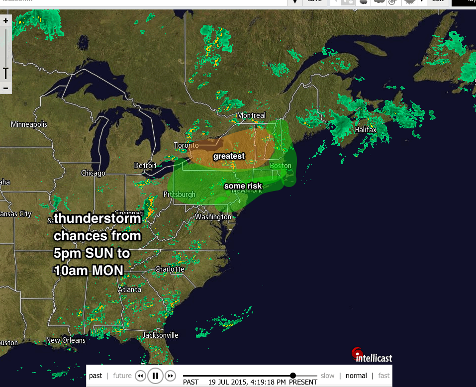

By late Monday night into Tuesday, a stronger disturbance will come close enough to spark widespread showers and thunderstorms for the overnight period. Daytime conditions on Tuesday will likely be dry, with decreasing humidity levels.
 |
| Accuweather.com |
 |
| 7online.com/weather |
Friday, July 17, 2015
HELTER-SKELTER IN THE SUMMER SWELTER
1. Weekend weather will be characterized by warm and increasingly humid conditions, with the best chance of afternoon/evening storms (scattered) coming on Saturday.
 |
| http://twister.sbs.ohio-state.edu/upper/charts/500 |
 |
| NOAA New York on Facebook and Twitter |
2. Hottest day of the summer thus far is poised to arrive for Sunday; temps make a run at 90 at most locations. Even Long island’s shore communities can briefly touch 90 degrees before the local sea breeze develops in the afternoon. Although actual highs will be in the lower 90s, very humid conditions will make it feel like it’s in the upper 90s to near 100.
3. Strong potential for heavy rain/thunderstorms Monday, in the late morning/early afternoon. Unstable air mass Monday will have the “trigger” in the form of a potent cold front as well as a mid-level disturbance to spark widespread storms. Update coming Sunday to address this further.
 |
| 7online.com/weather |
4. Tuesday and Wednesday are warm, but less humid, with perhaps a light passing shower on Tuesday evening. Next chance for more organized storms comes about next Friday.
Monday, July 13, 2015
Subscribe to:
Posts (Atom)