Thursday, January 30, 2014

THREE IMPORTANT STORMS TO WATCH AS WE OPEN FEBRUARY.....


But first, the weekend system is trending further north now. Most of the area will miss out on the bulk of the precip for this Saturday night into Sunday. A plain light rain is now the most likely outcome early Sunday, with a quick shot of light rain in the afternoon. The rest of the weekend looks dry. Conditions at game time Sunday night look to be warmer than the last update.


Some light snow is possible on Monday. Areas to the south and east of NYC and Long island stand the best shot of an accumulation snowfall. In fact, areas that got more than 2 inches of snow this past Wednesday stand the best chance of seeing similar or locally higher amounts.


NOAA: 7am Monday surface map


Thereafter, two potent storm systems will need to be closely monitored over the next seven to ten days. The first system is likely to make its closest approach on Wednesday into Thursday. A significant winter storm is possible, with a variety of precipitation types involved. The brunt of the storm would occur Wednesday before clearing. A change to plain rain or a mixed bag of precip is likely to transpire at the coast and in NYC, as only a shallow dome of cold air will be in place ahead of the oncoming storm.

Intellicast.com


Thereafter, another system will emerge out of the Gulf of Mexico for late next week, and make its closest approach by next Saturday. This time, a more substantial cold air mass will be in place which will either deflect the storm to our south and east, or aid in the development of a major snowstorm for the region. The track of the storm will determine how much, if any, impact there is to the area.

NOAA: Thursday morning surface map 2/6/14

Stay tuned.

Monday, January 27, 2014

SUPERBOWL SUNDAY SPELLS SEASONABLE TEMPS AND DRY CONDITIONS


1. Passing flurries from a coastal low for Tuesday night into Wednesday, particularly near the coast. A light dusting to an inch would be the maximum impact.
 
2. Moderating temps towards the end of the week. Pattern will transition from frequent arctic shots of cold air to that of a more regular, mid-winter cold around here from late this week through the first full week of February
 
3. Said patterns of this type will often feature building warmth in the southeast states. Implication of a clash between stubborn cold air entrenched to the north and warmth building to the south would make for a stormy month, with overall above normal precipitation for February.

image provided by tropicaltidbits.com

 
4. Next shot at significant winter weather will come Saturday afternoon into Sunday morning.  Developing low pressure could offer a shot at a wintry mix during this time.


Intellicast.com

 
5. Seasonably cold and dry for the historic Superbowl, with breezy conditions behind the departing storm. Next shot at a significant storm will come around Tuesday or Wednesday of next week, as a parade of storms begins to traverse the lower-48 states.

Wednesday, January 22, 2014

AFTER THE STORM, BRUTAL COLD WILL REMAIN ENTRENCHED ACROSS THE REGION....

1. Unlike the early January storm, temps will remain below 20 degrees Fahrenheit from now through Saturday morning for the entire region.  This stretch of such well-below normal readings is quite unusual, even by mid-winter standards.

2. Wednesday night and thursday night have a shot at 0 degrees in NYC, with the better shot Wednesday under clear skies, a fresh snow cover and light winds.

NOAA: Lows Wednesday night


3. "Calm cold" of Wednesday night will be replaced by dangerous, wind-driven cold by Thursday night. Wind-chill values will range from -10 to -15 degrees below zero, with actual temps of around 5-10 degrees above zero in NYC.

NOAA Forecast map for Thursday

4. Friday/Saturday: Remaining cold Friday, but winds die off. Saturday, we'll have to deal with a weak storm with light rain and snow, changing to light snow at night before ending. Minor accumulation.

Intellicast.com


5. Sunday/Monday: Wicked cold will be felt yet again, with single-digit wind-chill values likely. A more significant storm then moves near on Monday night and Tuesday, with the potential for more accumulating snow. Chance of hitting 0 at night again early next week.


Monday, January 20, 2014

MAJOR SNOWSTORM WILL IMPACT THE TRI STATE AREA TUESDAY AFTERNOON THROUGH EARLY WEDNESDAY MORNING...

Low pressure will develop along the coast tonight and track towards the region on Tuesday.
Snow will overspread the area from west to east in the mid-afternoon hours and become heavy at times by late in the day. 

Canadian Model shows a classic snowstorm for the area
Snow will persist throughout the night Tuesday night; with increasing winds, the temps will be brutal (very similar to the January 2/3 storm) with readings near 10 degrees during the height of the storm.

A general 6-12" is likely, with amounts of over a foot likely for southern and eastern sections of Suffolk County. Snow will likely be over by 5-6am Wednesday morning. 

Bitterly cold weather will persist behind the storm. NYC has another shot at 0 degree readings for Wednesday night.
Accuweather.com
Intellicast.com


Temps in the extended range are overdone for late this weekend, as another shot of arctic air will arrive by early next week.

Watch for snow chances for Thursday, with even a better chance over the weekend.

stay tuned

No video today due to technical difficulties...


Wednesday, January 15, 2014

A MORE SUSTAINED COLD WILL GRIP THE AREA BEGINNING THIS WEEKEND

PATTERN SHOULD PRODUCE MULTIPLE SNOW THREATS, AS WELL AS BITTER SHOTS OF ARCTIC COLD THROUGH FEBRUARY 5...


The winter has had some pretty impressive cold shots thus far. Going back as far as the last week of November, we've seen bitterly cold air charge in for a day or two. However, while nasty in its own right, the cold we've seen has been transient; warm air has made quick inroads, scouring out the arctic air masses. Even the blizzard back in early January was a quick memory the following week, with most of the snow cover actually being wiped out in short order.

But as mid-winter arrives, there are strong signs that a more sustained wintry pattern will evolve over the eastern two thirds of the nation.

Accuweather.com
NOAA Temp Probabilities From Jan 23-Jan 29th, 2014

Beginning this weekend, successive cold shots from the north will carve out a dip in the jet stream; cold will be longer lasting and warm air will have limited opportunity to gain ground through the first week of February. Also, fast-moving disturbances will lead the arctic charge in a way that will promote deeper and deeper cold to get involved, making for times of potentially severe cold during this time frame. The combination of these two elements will ultimately mean numerous snow chances.

Through Tuesday of next week, any snow/mixed precipitation will be light. The first shots of precip will come Friday night, then again Sunday, both bringing very minor impacts to our region. However, a more organized storm will try to get going next Tuesday night into Wednesday near the coast. This storm could yield a more widespread snowfall for the region.

 HIGHLIGHTS:

Friday/Saturday: light snow and rain during the day, then light snow Friday night into Saturday. Little to no accumulation.

Accuweather.com

Sunday: Another close call with a weak, fast moving storm, but at worst, it's a light snow Sunday with a dusting to an inch in some spots. The bigger story is the wind Sunday, with cold temps moving in Sunday night into Monday.
Intellicast.com

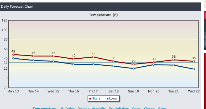
Tuesday/Wednesday: Stronger storm will develop, but its track is uncertain. A widespread snowfall would be felt if the storm is close enough to our coast. A cold shot will likely follow in for Thursday into Friday, where temps could stay in the teens and low 20s for Thursday and Friday. Watch for forecasted highs and lows to trend downward for late next week from where they are now!

Beyond the 24th: The sustained pattern of well-below normal temps should continue virtually unabated through the first 5-7 days of February.

The bottom line: Beginning this weekend, we're likely to be locked into a wintry regime, with multiple snow threats through at least the 5th of February and possibly a bit beyond that point, before the overall pattern can try and break down in a significant way!

stay tuned...


Monday, January 13, 2014

WINTER WEATHER WORRIES WON'T WANE AS WE HEAD INTO FEBRUARY...

NOAA New York on Facebook and Twitter


1. Storm for tomorrow should not deliver as much rain as the one from Saturday did. Heaviest rains will be from 6am-3pm in most spots, with drying out for the evening commute. Total rainfall should average about a half an inch.

2. Wednesday and Thursday are dry. Temps remain on the "warmer" side, with readings staying above normal levels for this time of year. A weak coastal low misses us during this period.

Intellicast

3. Friday night/Saturday: Some uncertainty with how close the next coastal low gets to our region. Best shot at snow is north and west of NYC, with several inches possible Friday night into early Saturday morning before things clear out for the majority of the weekend.  For the city and coast, it would be a mixed bag/plain rain. Bears watching.

4. Saturday night/Beyond: Overall pattern points to a very formidable period of wintry weather in the form of storms and cold for the last ten days of January and early February. Indications are that plenty of cold air will be available to tap into for any storms that come along.  Above average snowfall likely from Jan 21st-Feburary 5th. We'll have to see if another surge of arctic air can plummet into the east between the 25th and the 1st.
