Sunday, June 30, 2013

AS WE HEAD FOR THE FOURTH, RAIN CHANCES WILL WANE

1. NYC and Long Island were in a virtual rain-free hole this week, while areas to the north and south received at least an inch of precip in the last seven days. Thus, the overall forecasts proved to be unreliable for the metro area this week.

Intellicast precip amounts for the week


2. Persistance will pay off in terms of planning Monday and Tuesday; showers and storms will be relegated to areas north and west of nyc each day, with NYC/Long Island largely missing out

3. Change in the overall pattern will reduce rain chances even further from Wednesday through the weekend, as a more stable air mass takes hold. Fewer triggers in the atmosphere to ignite daily storms.  Highs will climb slowly each day, with typical nighttime lows in the 60s and 70s.

Intellicast


4. NYC will fall just shy of all-time June record rainfall.

Accuweather


Monday, June 24, 2013

INCREASING RISK OF FLASH FLOODING AND SEVERE WEATHER BEGINNING THURSDAY AND CONTINUING THROUGH THE WEEKEND

The first "official" heat wave of the season for the city is underway, but it'll break by Thursday as cloud cover increases.

Intellicast.com


Through Wednesday, the majority of thunderstorms during the day will be confined to the northern and western suburbs of NYC. However,  a very atypical weather pattern will evolve by late week, setting the stage for a daily barrage of heavy rains, thunderstorms and very muggy temps to linger across the entire region. An uptick in activity will start Thursday, but should really get going by Friday through Monday.

 The evolution of this wet pattern will most likely take several days to clear the east coast, making the threat of flooding almost certain for the usually vulnerable rivers and streams around the region.

Accuweather.com


The bottled up nature of the pattern-- akin to a wintertime "blocking" pattern, will mean that the front will move painfully slow, which will exacerbate the flood risk for the unfortunate areas that receive the most rains.

The maps from NOAA for Thursday, Saturday and Sunday illustrate the problem nicely, as the meandering front only crawls eastward....


Sunday could be a real problem for a widespread flood threat, as the front makes its closest approach.

The 7-day totals forecasted from now through Monday night from NOAA show an average of 2 inches in the red shading:

However, with the very rich availability of moisture in the atmosphere, the potential is there for some places to see much higher totals, particularly if a certain location gets hit multiple times in one day.


So to sum up:


  • heavy rain/thunderstorms will increase in coverage and intensity from Thursday onward across the entire region.
  • the weather will be most prone to flare-ups of heavy showers and storms during the afternoon and evening hours --- similar to a Florida-type weather pattern. It will not rain the entire period
  • Closest approach of frontal system will happen Sunday into Monday, which should give us the best opportunity for widespread heavy rainfall as opposed to scattered showers and storms. 
Another update will be needed by Wednesday


Sunday, June 16, 2013

OVERALL DRY WEEK, WITH A PRECARIOUS START

Father's Day will be cloudy across the tri state area, with areas to the north and to the south of NYC having the best chances at seeing any showers and thunderstorms for today and tonight. The coast and city have the more stable air and are poised just to the south of the best overall atmospheric parameters  which could trigger anything.


for Monday into early Tuesday, the forecast becomes marred by low predictability. Overall however, the best chances for organized storm activity will come Monday night into early Tuesday morning, as the next front comes through.

After we get by Tuesday morning, the weather looks dry and very pleasant for Wednesday and Thursday, before a more humid air mass takes hold for late in the week.

Intellicast
The bulk of the rainfall nationwide looks to stay to our south over the next five days.

WPC 5-day rainfall totals through 7am Friday June 21st

The possibility of warmer, but wet conditions looks the most likely as we go into the week of the 24th.

NYC's May/June Rainfall (most ever recorded from May 1-June 30th)

year...May/June rains

1989.....19.03"
1972.....17.69"
2013.....17.60"
1984.....15.50"
2009.....15.23"
2003.....13.70"
1968.....13.21"
2006.....13.17"
1948.....13.10"
1998.....12.88"

Tuesday, June 11, 2013

STRONG LATE SPRING/EARLY SUMMER STORM WILL INDUCE MORE FLOODING ACROSS THE TRI STATE AREA FOR THURSDAY INTO THURSDAY NIGHT


After a windy, but dry day on Wednesday, a potent coastal storm will develop and track towards the area on Thursday with more heavy rain and isolated thunderstorms. The region will be on the northern side of the storm, which will limit severe weather chances aside from the flooding.

Accuweather
In the zone in red, a significant wind damage/tornado threat exists for Thursday. If the forecasted path of the low pressure holds firm, the immediate tri state area will only experience heavy rain and isolated severe thunderstorms. However, an additional update may be needed if the severe weather threat area gets bumped north tomorrow afternoon. 
 
Strong winds will mount on the coast, with frequent gusts to 40mph possible in the afternoon and evening. 

Temps will be miserable for this time of year as well, with readings struggling to get to the mid-60s.
 
The storm will tend to linger a bit into Friday with residual scattered showers and times of cloudiness
 
the weekend still looks warm and dry.

Sunday, June 9, 2013

A NEW WEEK, WITH MORE UNSETTLED WEATHER LOOMING

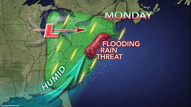
1. Heavy rain threat will begin anew Monday into Tuesday, as a slow moving warm front pushes through the region. A general 1-2 inches of rain area-wide is likely, with some higher amounts possible in isolated locations.  Best opportunity for heavy rain will be Monday afternoon into Monday evening, with only light to moderate rain falling during early Monday morning through early afternoon.


Accuweather
2. Rain tapers off overnight Monday into Tuesday, but the threat of showers will increase for Tuesday into Tuesday night with the passage of a cold front.

3. A break comes for Wednesday, with dry conditions. Another significant rainfall is possible on Thursday, with the potential for another 1-2 inches of rainfall. This will need updating.

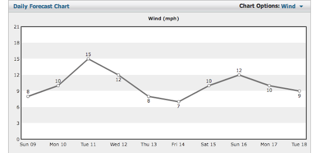
Intellicast WInds


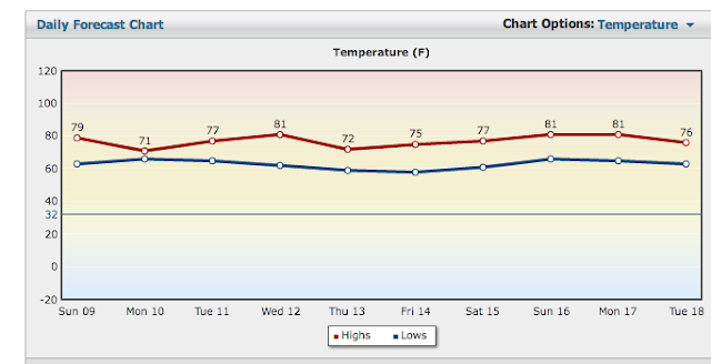
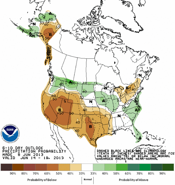
4. Friday through the weekend looks decent for now, but no summer-like warmth is on the horizon just yet, as the overall pattern will keep the searing heat to our south and west over the southern plains states.


Intellicast Temps

CPC 6-10 day temps

CPC 6-10 day precipitation