Wednesday, December 31, 2014

WARMING UP WITH RAIN BY LATE THIS WEEKEND...

1. After a cold New Years' Day, temps will run closer to 40 for both Friday and Saturday.

2. Rain should break out Saturday evening and continue for much of Sunday before ending Sunday afternoon. Temps overnight Saturday night into Sunday will spike into the 50s for most places near the coast, with 40s further inland.


3. Renewed cold shot of air comes in by Monday, with an even sharper plummet in temps by mid-week; potential is there for temps not to rise above 20 during the day either wednesday or thursday.

7online.com/weather


4. Significant wintry precip will remain elusive during the next week or so. Storm systems continue to either move to our west (which draws in warmer air just like this upcoming weekend) or they move too fast by way of an active northern Pacific jet stream.


Saturday, December 27, 2014

TUMBLING TEMPS AS WE TURN TOWARDS 2015!

NOAA New York on Facebook and Twitter. 


1.  Sunday is mild, but then an arctic cold front crosses the region.  Before the temps drop, light rain arrives Sunday afternoon and evening before tapering off for most areas.

2. Most of Monday is dry, but clouds will fill back in again late in the day. Some light snow could clip  the city and coastal regions on Tuesday, with coatings to an inch of snow in some spots. Outside of Sunday's rain and Tuesday's possible light snow, conditions will be dry through the week.

3. Temps are at their coldest from Tuesday to Thursday, before readings start to moderate by week's end.

7online.com/weather


4. No significant winter storms through at least Friday and probably through January 5th.  Although the overall pattern will feature colder air,  a fast jet stream should keep any disturbances moving through swiftly; these storms will not have time to strengthen, gather moisture and deliver copious amounts of precip.  This is quite a departure from the forecasted active, stormy winter that most circles (including here) were advertising for the eastern states in the various pre-season winter outlooks.

Wednesday, December 17, 2014

DECK THE HALLS WITH WILD AND STORMY

The weather will remain fairly tranquil through Saturday night. Temps will stay in the 40s and the pesky breeze of Thursday will relinquish on Friday.

By Saturday night, we'll see clouds increase and light rain starting to spread in by Sunday morning. After a brief period of light rain Sunday, skies will generally remain cloudy through Wednesday; however, no real significant rain will take shape until sometime later Monday or even Tuesday.

By Tuesday, a powerful storm will be gaining strength over the midwestern states. This system has a  fairly high potential to produce moderate to heavy rains for Tuesday night into much of Wednesday before it ends Wednesday night. As the storm passes through, very mild air will get drawn north and up the eastern seaboard; the dramatic clash of winter and fall air masses will lead to a few thunderstorms Wednesday!  Strong southerly winds will be felt on Wednesday, with speeds approaching 40mph (perhaps higher) and remaining gusty through Christmas day.

Meteorologist Joe Cioffi on Facebook: GFS evolution of storm Tues/Wed

After starting out quite mild on Wednesday, temps will plummet some 20-30 degrees lower by Wednesday night and Thursday on the heels of a strong northwesterly wind and the departing storm.  A few snow showers could develop from time to time for Christmas day, with perhaps a dusting of snow in isolated pockets.

7online.com/weather


The major storm for next week will lead to significant travel delays, particularly across the mid-west. In addition, it is this storm which will likely serve as the catalyst to produce a prolonged cold, stormy pattern from Christmas to New Years Day and possibly beyond.

more over the weekend.

Thursday, December 11, 2014

DRYING OUT AFTER THIS WEEK'S NOR'EASTER....

1. Region finally will be rid of stubborn, strong mid-week nor'easter during the weekend.  Skies will begin to brighten more on Friday, but there can be a stray flurry on Friday night. Temps remain chilly in the upper 30s to low 40s on Friday.

2. Outside of a few scattered flurries this weekend, the region should remain dry, with varying amounts of clouds and sun for Saturday. By Sunday and Monday, we'll see mostly sunny skies and temps rebounding into the mid and upper 40s.

Accweather.com: Geminid Meteor Shower


3. Mainly dry through Tuesday afternoon. A weak, fast-moving system will spark a shot at some quick-hitting rain on Tuesday afternoon before exiting the region early Wednesday.  Winds should pick up somewhat on Wednesday with a chilly northwest flow of air; skies may remain on the cloudy side for mid to late week as another fast-moving system draws near by late next week (Thursday night).

Intellicast.com


4. Potential remains high for active, stormy period of weather for the last ten days of the month. Active southern jet stream combined with renewed cold air masses should make for some periods of disruptive weather during the busy holiday season.

Sunday, December 7, 2014

STRONG COASTAL STORM WILL INFLUENCE OUR WEATHER FOR MUCH OF THIS WEEK....

Clouds will gather on Monday with a chilly breeze; northerly winds will begin to turn northeasterly . Light rain/drizzle should develop towards sundown, with fairly steady rain commencing around late evening into the overnight Monday night/Tuesday from south to north. Temps start out in the 30s, but then they rise into the 40s at night. Freezing rain/ice threat is high for Orange County in New York.
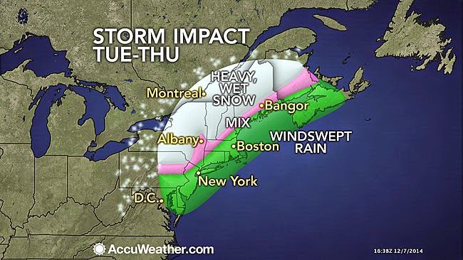
Accuweather.com 
Meteorologist Joe Cioffi


On Tuesday, the coastal storm will begin to intensify. A wind-swept, heavy rain will be felt for much of the day and early evening before rain tapers off for Tuesday evening at the coast and in the city.  Elsewhere,  rain should linger north and west of I95 and transition to snow before ending. Moderate coastal flooding will be likely Tuesday and Tuesday night at the coast. Winds could gust as high as 50mph for the city and coast, with 40mph gusts possible further inland.

For Wednesday, we'll remain cloudy. A few quick-hitting rain and snow showers should move through during the day for all areas. Winds will subside, but remain gusty.
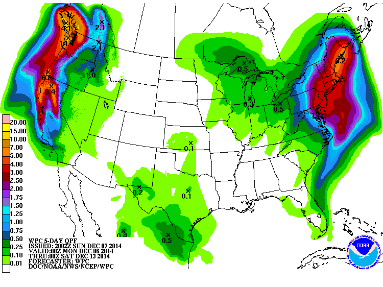
NOAA-5 day liquid equivalent precip totals are a widespread 2"+


While the steadiest, heaviest rainfall will be north of our region on Wednesday,  the overall configuration of the jet stream will not allow the storm to completely move out of the northeast states. Accordingly, our weather will remain unsettled through Friday, with clouds prevailing for much of the period; scattered rain and snow showers will pose a threat of moving through from time to time, particularly during the day, until the stubborn low pressure is able to weaken and pull further north sometime on Friday.
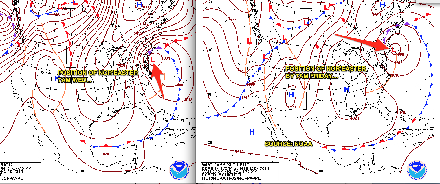
NOAA: Nor'easter's slow crawl from Wednesday to Friday


Thereafter, our weather will improve even more by the weekend, with temps rebounding into the mid and upper 40s and rainfall chances finally diminishing.

Intellicast.com


In the long term, a cold and stormy regime should continue throughout the rest of the month, with transient spells of above-normal temps. After the 20th, there are strong signs that the overall pattern will begin to "lock in" to winter,  markedly raising the prospects for bouts of sustained cold and disruptive snows during the busy holiday season.

Wednesday, December 3, 2014

UNSETTLED WEATHER FROM SATURDAY THROUGH WEDNESDAY

POTENTIAL FOR PROLONGED NOR'EASTER FOR LATE SUNDAY NIGHT INTO TUESDAY

After dry and cool conditions for Thursday and Friday, warm air will ride up the eastern seaboard Friday night into Saturday; this process, in conjunction with a weak disturbance in the atmosphere will lead to light rain chances increasing from south to north beginning Friday night.  This rainfall will be at its steadiest during much of the day on Saturday before ending Saturday night.  Amounts through this time frame will generally be under an inch. Some of the hilly terrain north of Interstate 78 may start as frozen precip on Friday night.

models/weatherbell.com: Steadiest rains fall during Saturday

Thereafter, attention will shift to a developing storm off of the Virginia coast on Sunday; this storm will meander very close to our shoreline (perhaps for several days) as a blocking high pressure prevents it from going out to sea. However, the ultimate track of this storm and the proximity to our coast will determine whether we see a soaking, wind-driven rain for Sunday nigh into Monday. Regardless, the combination of the above factors and the full moon will lead to some coastal flooding issues for early next week at the times of high tide.

MOON PHASE CALENDAR: 


The probability of seeing heavy snowfall for NYC and the coast is low. 

Intellicast Temps:

Beyond Saturday, there is a low degree of predictability for the early week storm; however, some of the more reliable models are showing some significant impacts for early next week.

Another update will be needed Friday night. 

Stay tuned


Saturday, November 29, 2014

DECEMBER OPENS WITH VARIABLE TEMPS AND LIGHT PRECIP CHANCES

1. Pre-Thanksgiving snowfall ideas from here were overdone near the coastal plain. Inland areas mainly picked up between 4-6 inches with isolated higher amounts:

Left: NYC Weather Guy snowfall idea for 11/26/14
Right: NOAA storm total snowfall for 11/26/14

NOAA: Rain/Snow line during 11/26/14 storm

2. Warmer Sunday through Monday night, then below-normal temps for Tuesday (our coldest day during the week) with highs only in the 30s. Temps steady at night Sunday night, with plenty of cloud cover. Only precip of note through the period would be very light rainfall on Monday night with the passage of a cold front. 

3. Tuesday night and Wednesday, we have a good shot at light rain, ending by afternoon on Wednesday.  Thursday is dry with temps in the upper 40s. Another shot at light rain will try and work through the region on Friday. 

Intellicast Temps: 


4.  East-to-west flow in the jet stream will keep prolonged extreme cold and major storms a low possibility through the 10th. 
Accuweather.com

Monday, November 24, 2014

MAJOR WINTER STORM ON THE WEATHER MENU FOR WEDNESDAY AND WEDNESDAY NIGHT

Incredibly, after record high temps for Monday, the stage will be set for the region's first significant winter storm of the season.


The primary hazards associated with this vigorous storm will be most felt north and west of Interstate 95 and points north and west; the primary weather hazard will be heavy snowfall which will make driving very difficult for Wednesday afternoon and evening.

A light rain-snow mix will overspread the region as early as overnight Tuesday night/Wednesday morning. However, the steady, more meaningful precip will get going late Wednesday morning, and continue heavy at times; snow will change to rain for NYC and points south and east, cutting down somewhat on accumulations there. However, north and west of NYC and the coast, snow will take over as the primary precipitation type.


As the low pressure begins to pull away, a period of snow will take place all the way down to the coast during sometime Wednesday evening; this is the best opportunity to see a quick accumulating snow at the city and coast, where a general 2-4" is a good possibility. Areas in and around the north shore of Long Island at the highest elevations could see amounts closer to 6" by the time it's all over!

if you must travel, leave early and in the morning hours if possible, especially if you're driving from south to north.

In the pre-dawn hours of Thursday, all precip will taper off.

Intellicast.com Temps


Behind the storm, it's unseasonably cold and dry through the weekend, with a noticeable warm-up by Sunday.


Saturday, November 22, 2014

POTENTIAL INCREASING FOR DISRUPTIVE, PRE-THANKSGIVING STORM

First, there are no changes to the forecast rationale for Sunday and Monday. See previous posts.

Colder air moving in Tuesday will set the stage for our mid-week problem.

The models are slowly coming into line on a powerful, but fast moving storm for Wednesday into Wednesday night. This storm has the potential to deliver a heavy snowfall inland and a rain/snow mix along the coast.  The track is uncertain:

accuweather.com
A track closer to the coast would mean more snow inland and more rain along the coast. A track further out to sea would mean less snow and less overall impact, but it would make for more snow on the coast (warm air would not push in and change the precip to rain with an offshore track). 

the volume of travel done on Wednesday and the storm's impact on a wide swath could lead to very significant delays and cancellations

Snow  or a rain/snow mix would begin around mid-to-late morning and continue through the day before ending late Wednesday night. 

The exact effects on sensible weather will be ironed out over the next few days
and another update will be needed on Monday

stay tuned. 

Saturday, November 15, 2014

AFTER MONDAY'S RAIN, JANUARY-LIKE COLD FOR TUESDAY AND WEDNESDAY

1. Quiet weekend overall, but continued unseasonably cold for this time of year. Sunday actually warms towards the upper 40s, but it's still a few degrees below average high temps. Saturday night is quite cold, but winds are light.

2. Sunday night into Monday: Coastal storm brings a good soaking rain to NYC and the coastal plain. Further north and west across the Hudson Valley, precip should start as snow, making for a slick Monday morning commute. Warming temps means that any frozen precip will be a nuisance; rain will work in as the dominant precip type by mid-morning Monday.

Accuweather.com


3. Monday night, it begins to clear, but the winds start to turn northerly. These winds will help to usher in the coldest air of the fall season; temps will be hard-pressed to get out of the 30s Tuesday and again Wednesday.  Strong winds Tuesday will make it feel like it's in the 20s!!

Intellicast.com Temps


4. Some moderation of temps by Thursday, with highs in the mid 40s; however, readings will be below-normal levels, as our normal high temps should still be near 50 degrees.

Sunday, November 9, 2014

WINTER'S OPENING SALVO ARRIVES AHEAD OF SCHEDULE....

1. Dry through much of this week. Clouds increase on Tuesday as temps warm up nicely. Available moisture is limited, so chances of very light rain will be confined to late at night Tuesday night/early Wednesday morning.

2. By Thursday, the first of many strong shots of cold air will begin to plummet into the region on a stiff northerly wind. Potential is there for a small storm system to give us precip (rain/snow) for late Thursday night into Friday morning, particularly towards the coast. Update will be needed.

3. By Friday afternoon, even more cold air rushes in! Temps over the weekend are stuck in 40s during the day through at least next Monday.

Overall pattern late week and early next week: Cioffi: PIX-11/Facebook


4.  On the heels of the Thursday "clipper low," a stronger, more vigorous storm will develop near the Gulf of Mexico and track northward for early next week. This system has the chance to offer a more substantial round of rain/snow Sunday night into Monday, but models have been inconsistent in terms of the storms' eventual track. Bears watching.

5. Outstanding mid-November cold (compared to averages for this time of year) will hold its grip in place through the 20th. Persistent, blocking pattern is the culprit, along with above-normal snow cover in the Northern Hemisphere. We should expect many days where highs are only in the upper 30s and lower 40s, with lows in the upper 20s to lower 30s area-wide; even colder away from NYC at night!

Rutgers University Snow Lab:
Left: Snow Cover 10/8/14
Right: Snow Cover 11/8/14

Intellicast Temp Forecast

Weatherspark.com: Average highs in November for NYC

Weatherspark: Average time spent in temp categories since 1869

Sunday, November 2, 2014

NOVEMBER WILL BE COLD AND STORMY ACROSS THE REGION

1. Weekend nor'easter was the second straight storm to over-perform when compared to the forecast. Rain lasted the entire day for NYC and points east, with amounts from one half to one inch of rain.

NOAA Precip estimate shows .50-1.00 fell on Long Island for 11/1


2. Mainly dry through Wednesday, but there could be widely scattered showers Tuesday night as a warm front moves through.  Most if not all of Election Day is dry. Temps start to creep back up after Monday (tomorrow).

Accuweather.com
www.PIX11.com/weather


3. Another coastal storm for the end of the week, with rain and wind likely thursday afternoon into Friday morning. Clearing for the weekend, with cooler temps taking hold.  Windy on Friday night and Saturday. Look for another coastal storm and cold shot sometime during the week of the 9th.

4. In general, an active pattern of storms should combine with slightly colder-than-normal monthly temps through much of November, setting the stage for another rough winter in NYC.

Monday, October 27, 2014

MAJOR COLD “SPELL” LOOMS FOR HALLOWEEN WEEKEND…

1. After a gorgeous Tuesday, temps begin to tumble on Wednesday and Thursday. Threat of rain in the form of showers Wednesday during the day will be minimal; areas to the west and north of NYC will stand the best chances. 
 
2. Calm Thursday and Friday. All of Halloween will be sunny and cool, but clouds rapidly lower and thicken toward evening. 

Intellicast


3. Our first intrusion of bona fide arctic air will hit the region beginning late Friday night and it will last through the weekend. Temps will struggle to get out of the 40s for daytime highs Saturday and again Sunday, with wind-chill values in the upper 30s to low 40s. Very windy Saturday. 


4. Low confidence forecast remains for sensible weather this weekend. Complex pattern evolves as the arctic air plunges southward.  A storm will develop to our south and track northeastward, with both an initial shot of precip overnight Friday night and another shot at precip on Saturday night. The potential is there for accumulating snow in the interior of CT and the Lower Hudson Valley; in a worst case, accumulations could make it down to the coast, as we saw back in late October 2011 and again with the post-Sandy storm in 2012.
 
More later…

Saturday, October 25, 2014

PREPARE FOR ANOTHER SNOWY WINTER ACROSS THE AREA

THIS WINTER:

If the consensus holds for a snowier-than-normal winter,   it would be the 6th winter out of the last 7 with above normal snowfall...and that has not happened since the 1880s.


Accuweather.com


This year, many of the same factors that contributed to our snowy pattern last year are yet again in place. A border-line El Niño,  a favorable overall water temperature profile in the Atlantic and the Pacific Oceans  and above normal October snow cover in Eurasia should sew the seeds for another cold, snowy winter, with amounts compared to seasonal averages well-above normal area-wide, particularly towards the coast.

One would think (and some would hope) that the odds of beating last year's robust snowfall totals would be low.

But the last time NYC saw back-to-back 50 plus inch seasonal snowfalls was not long ago -- 2009-10 and 2010-11. Indeed,  with few exceptions, the late 1990s through 2013 will -- by far and away -- be remembered for being one of the snowiest periods of weather around these parts since the 1940s!


2013-14 Winter Stats: Courtesy of Weather works inc. 


NY NJ PA Winter Forecast

Weatherbell Winter Forecast

NOAA Winter Forecast

Weather Channel/WSI Winter Outlook

Accuweather Winter Outlook

WINTER 2013-2014:

Last winter saw heavy snows blanket the area in January and February.  NYC recorded 57.3 inches for the season, with many locales totaling similar results.

Things got started on December 14-15, when our first coastal storm brought half snow/half rain to the coast, while dumping heavy snow inland.

The first snowstorm with little to no rain occurred shortly after the New Year, with blizzard conditions, 8-12" of new snow, and bone-numbing cold which followed directly in behind the storm.


A second potent winter storm came around Martin Luther King Jr. Day, with similar accumulations, but less wind. February had a close call early on, but then another winter storm came calling February 13-14, with a blinding snowfall that snarled the morning rush. In the evening, snow changed to a drenching rain for the coast, while areas to our north remained with frozen precip.

Toward the end, the interesting part of winter was what DIDN'T happen; three storms missed the area to the south in the month of March, sparing the area the chance of smashing all-time seasonal snowfall records.

Bottom Line: In the very long term, subtle, but cyclical shifts in the overall hemispheric and water temperature pattern over the next several years may well yet spell the decline of prolific snowy seasons like we've had.  However, in the short run, while maybe not as cold as last year, we should expect to see a season which once again will be capable of producing very disruptive wintry events similar to those we've grown accustomed to, and this is in line with the historical trends of the last 15-20 years.


VIDEO: SHARPLY COLDER CONDITIONS TO OPEN NOVEMBER

Watch Now

Monday, October 20, 2014

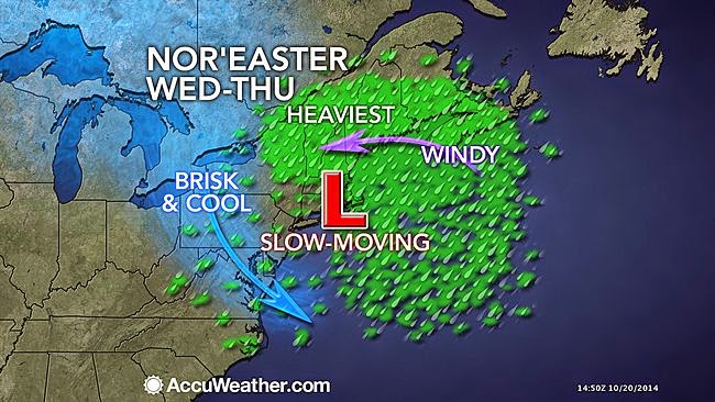
SLOW-MOVING NOR'EASTER WILL INFLUENCE OUR WEATHER FROM TUESDAY THROUGH EARLY FRIDAY...

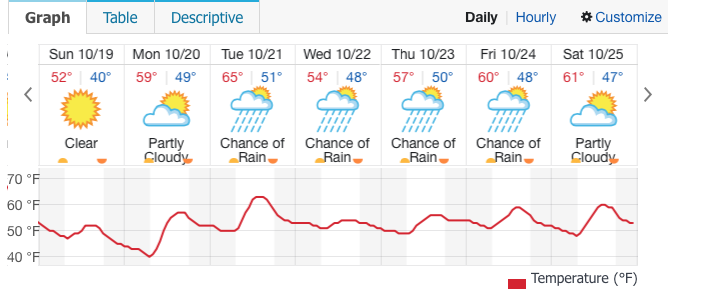
1. Tuesday: Light rain will affect eastern Long Island as well as the northern suburbs of NYC during the overnight hours.  Less rain overnight for the NYC metro area. Showers during the day will be scattered in nature; breaks of sun could develop at times, with temps in the 60s.

2. As the storm takes shape to our south, light rain will develop from southwest to northeast Tuesday night and continue through Wednesday. A steady, moderate rainfall takes shape for Wednesday afternoon and night area-wide, with a few thunderstorms possible.

Accuweather.com

intellicast.com


3. By Thursday, the rainfall once again becomes scattered, with the more organized area of rainfall vacating the region by mid morning. Residual showers could threaten any time from Thursday afternoon through Friday morning, but we should dry out completely for late friday through the weekend.

Thursday, October 16, 2014

A CHILLY WEEK NEXT WEEK

The warmth of this week took us back to typical temps that we'd see in late August/early September. However,  after a pleasant Friday and a warm, windy day Saturday, our temps will become much cooler beginning late Saturday afternoon and night,  and this will continue for the balance of the upcoming week.

Intellicast.com shows the location of the cold front 8am Saturday morning...


In fact, highs on Sunday will struggle to reach the mid-50s; that's easily 10 degrees below where daytime readings should be for this time of year.  It'll be breezy both weekend days, but winds will feel much chillier on Sunday since by then, they will prevail from a northerly direction.

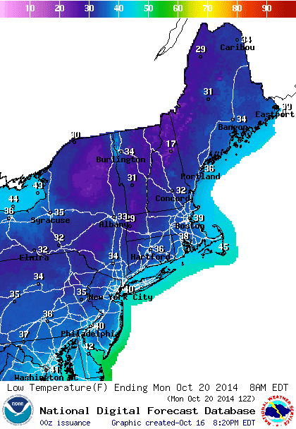
Our first opportunity for widespread sub-40 degree low temps comes Sunday night, especially outside of NYC.

NOAA-Low temp forecast Sunday night/Monday morning


Intellicast.com
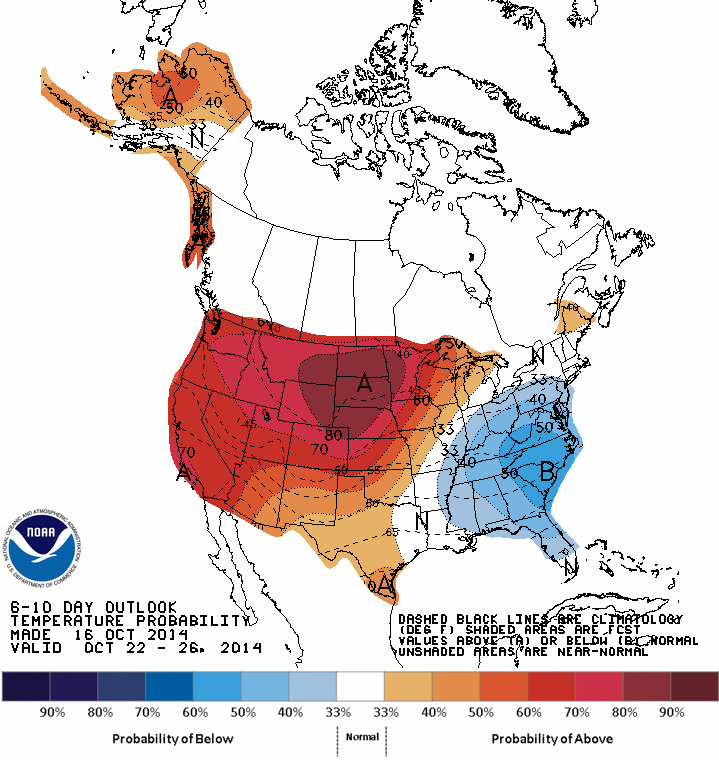
Climate Prediction Center: 6-10 day temp probability shows "below normal" in the eastern U.S. 


The rain we had this week looks to be a pre-cursor for more rain next week. Another slow-moving storm will develop to our south by Tuesday and meander northward during mid-week. This could lead to a period of steady rain and increasing winds Wednesday; while the exact amount of rain for mid-week next week is uncertain, easterly winds will help to lock in the clouds, as well as low level moisture and cool temps beginning Tuesday and continuing through much of Thursday, as the stubborn storm slowly moves away.

Sunday, October 12, 2014

POTENT STORM FOR THURSDAY...

1. Clouds lower and thicken tonight into Monday, but best chances for any light showers should be inland on Monday and Monday night. Warm southerly flow will push temps steadily upward Monday and this will continue through Wednesday, in spite of abundant cloud cover. Nighttime lows will stay quite mild through Thursday night.


Accuweather.com


2. Dry through the first half of Wednesday night. Strong, slow-moving frontal system encroaches upon the region, with heavy showers and some thunderstorms for late Wednesday night through much of Thursday before ending. Total rainfall should average around 1 inch, with some higher amounts possible in any thunderstorms. High temps stay rather mild during Thursday, but temps start to get knocked back towards the low 70s by Friday.

WPC Total Precip 7am Wed-7am Fri

U.S. Drought Monitor


3. Dry weekend, but temps tumble Saturday night with another frontal passage.  Temps will hover around 60 for highs on Sunday, some 15-20 degrees lower than where they will be for mid week! Another potent storm will take aim at the region around Tuesday, with another soaking rain.