Friday, December 6, 2013

Tuesday, December 3, 2013
ACTIVE WEATHER PATTERN SHAPING UP FOR DECEMBER
The stretch of benign weather with very little precipitation over the last few months is now transitioning to a more stormy. active picture overall. The presence of both very bitter arctic air over the Canadian Prairies (bolstered by a healthy snow cover over our neighbor to our north), as well as the typical strengthening of the jet stream, should spell lots of opportunities for rain and eventually frozen precip types as we move deeper into the month. This is in contrast to last December already; chances for storms didn't materialize until the last ten days of the month, and few of them managed to bring any wintry weather. But with the extreme contrast in air masses this month, we should look for a combination of wild temp swings (which we've seen already) and generally speaking, an uptick in storminess.
HIGHLIGHTS:
Wednesday night/Thursday: Widespread drizzle and fog should develop ahead of the warm front and continue through the morning. Light rain and drizzle should scour out in the afternoon Thursday, with very mild temps. Readings many top 60 in the normally warmer spots around the region, even in NYC.
Thursday Night/Friday: Steadier rains develop late at night and should persist through much of Friday and Friday night. Up to an inch of liquid is expected with this front. Rain will transition to snow and sleet well north and west of the city and coast Friday night, so that extreme northwestern New Jersey could pick up a light accumulation late Friday night into early Saturday morning before precip ends everywhere.
On Friday morning, it's still quite mild! However, temps will tumble steadily through the daytime hours and through the night Friday night as the winds shift to the northwest.
Saturday: Best looking day of the weekend, but we're cold again. Saturday night looks quite chilly.
Sunday-Tuesday: Complex series of storms will move through.
Potential for a wintry mix for all areas for at least a few hours during the afternoon, eventually becoming rain at the coast and in the city for Sunday night into Monday. As you head well away front the city and coast, it's more of a wintry mix scenario. This will need fine tuning.
Another storm may follow in behind for Tuesday into Tuesday night.
HIGHLIGHTS:
Wednesday night/Thursday: Widespread drizzle and fog should develop ahead of the warm front and continue through the morning. Light rain and drizzle should scour out in the afternoon Thursday, with very mild temps. Readings many top 60 in the normally warmer spots around the region, even in NYC.
 |
| Intellicast |
 |
| Intellicast: Hourly Temp Forecast for December 5 (Thursday) |
Thursday Night/Friday: Steadier rains develop late at night and should persist through much of Friday and Friday night. Up to an inch of liquid is expected with this front. Rain will transition to snow and sleet well north and west of the city and coast Friday night, so that extreme northwestern New Jersey could pick up a light accumulation late Friday night into early Saturday morning before precip ends everywhere.
On Friday morning, it's still quite mild! However, temps will tumble steadily through the daytime hours and through the night Friday night as the winds shift to the northwest.
 |
| Intellicast 7-Day Temp Forecast |
Saturday: Best looking day of the weekend, but we're cold again. Saturday night looks quite chilly.
 |
| NOAA Lows Saturday Night |
Sunday-Tuesday: Complex series of storms will move through.
Potential for a wintry mix for all areas for at least a few hours during the afternoon, eventually becoming rain at the coast and in the city for Sunday night into Monday. As you head well away front the city and coast, it's more of a wintry mix scenario. This will need fine tuning.
Another storm may follow in behind for Tuesday into Tuesday night.
Sunday, December 1, 2013
Wednesday, November 27, 2013
WATCHING A COASTAL STORM FOR MONDAY INTO TUESDAY...

Behind our pre-Thanksgiving storm, the weather will be quiet, but cold for late this week into the weekend.
 |
| Intellicast |
By Saturday and Saturday night, a frontal zone will draw near the region, adding plenty of cloud cover by Saturday night into Sunday. Some very light rain or a rain/snow mix is possible Saturday overnight into Sunday; areas to the east of NYC stand the best chance at seeing any precip during this time frame. Chances for light precip will persist into Monday, but amounts and location of the rain will be very spotty.
Meanwhile, a more organized low pressure will begin to take shape along the frontal zone to our south early next week. It is here where the forecast will depend on the track of this low. If there is an impact at all, the prospects for mainly rain in the city and coast are high, but as you get further inland, the chances for more significant frozen precip do exist if the timing and track are just right.
By Wednesday, skies clear out, but it'll be breezy in the wake of the departing storm. Temps for Wednesday and Thursday will be near their normal levels for this time of year.
There are signs in the long term which point to a rather cold, stormy December in the making.
The bulk of the cold will be confined to our west, but will try and press in from the northern plains states. This should aid in the development of storms where the warmth (over the southern states) and cold intersect.
More to come Saturday or Sunday.
Sunday, November 24, 2013
COLDEST THANKSGIVING SINCE 2002 ON THE MENU
 |
| 1985 and 1994 also had highs of 41 degrees |
1. Coastal storm will disrupt travel Tuesday night into Wednesday night. Heavy rain and gusty winds likely during this time frame, with strong gales out of the south. Mild and breezy. Much needed rainfall in most areas will average 2 inches, possibly more.
 |
| Add caption |
 |
| Intellicast |
3. Long term trends point towards below normal temps to open December. With storm track becoming evident, prospects for an above normal snow cover nationwide will continue. However, no El Nino/La Nina signal is expected through the winter, which will complicate any shot at clues beyond a week or two as to how harsh the winter will be.

Wednesday, November 20, 2013
BITTERLY COLD TEMPERATURES LIKELY FOR SUNDAY, WITH RECORD COLD LOW TEMPS POSSIBLE MONDAY MORNING
The latest push of arctic air over the eastern states will out-do the last two shots beginning late Saturday night and continuing through Monday.
The worst of the cold will be accompanied by very strong gusty winds Saturday night through Sunday, so that wind-chill values will be in the teens on Sunday and Sunday night, with actual high temps struggling to reach the mid 30s. The point-and-click temps from a few days ago depicting highs near 40 on Sunday are in retreat mode, as the models pick up on the ferocity of the cold, which, for the time of year compared to normal, are nothing short of brutal!
 |
| Old Intellicast Temps From Monday |
 |
| New Intellicast Temps |
 |
| NOAA Forecast for this Sunday's Highs back on Monday |
 |
| New NOAA forecasted HIGHS Sunday |

Temps will come up gradually Monday; winds will relax on Monday, but highs will still be well below normal levels, only making to the mid and upper 30s for high temps.
Tuesday and Wednesday are problematic. A series of storm systems will be the focus for the extended forecast.
Overall, the pattern is becoming more volatile. Airport travel during one of the busiest times of the year next week may be a big issue nationwide, even if our area does not feel the effects of any particular storm.

In terms of our weather, the development of a coastal storm (and its path) and a renewed shot of well below normal temps for late next week will have to be fine-tuned over the weekend.
Thanksgiving weekend looks chilly at this time.
PRECIP: The sure shot at rain will arrive on Friday, but amounts and intensity will be very light. A coastal storm will not get its act together this weekend. The bulk of the steadier rains should arrive with the passage of the front sometime Saturday morning, before things clear out.
Small disturbances on the heels of the powerful arctic frontal boundary on Saturday evening will lead to the development of snow showers in most locations.
more to come this weekend...
Monday, November 18, 2013
MORE FRIGID TEMPS ON TAP TO OPEN THANKSGIVING WEEK
After a tranquil, late week temp rebound, we'll see the development of a storm for Saturday night into Sunday. This storm will most likely bring us a chilly rainfall and gusty winds during this time frame. Some wet snow flakes will mix at the end when precip lightens up Sunday morning. Well north and west of the city, there is the prospect of a wet snowfall at the end of the storm, but details are still in the works.
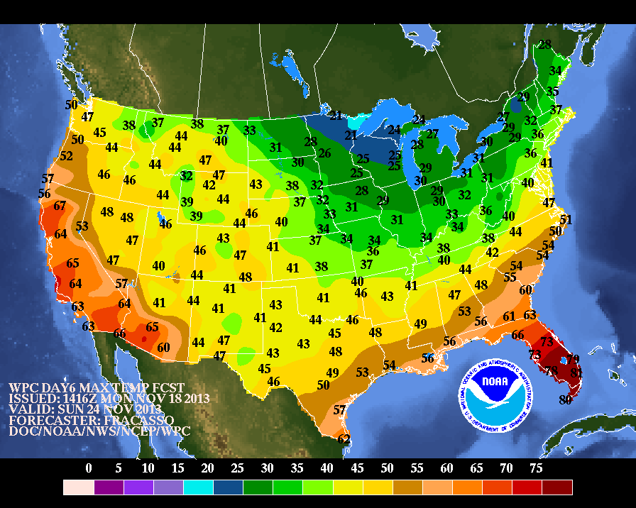
What is much more certain is a renewed push of well-below normal temps for Sunday and Monday, with some relaxation for Tuesday. The intellicast temps are cold, but likely overdone for Sunday; low-level cold rushing in behind the storm should be plentiful, which is tough for forecast models to pick up.
Notice how far south the freezing line is for daytime HIGHS on Sunday in the NOAA graphic. Also notice that readings are only near 20F up near Minnesota!
With all of Canada covered in snow, combined with the plunging of the jet stream like we've seen for the past two weeks or so, the stage is set for more waves of winter-like air to have a free pass at the eastern states as we move into December.
more tomorrow or Wednesday
What is much more certain is a renewed push of well-below normal temps for Sunday and Monday, with some relaxation for Tuesday. The intellicast temps are cold, but likely overdone for Sunday; low-level cold rushing in behind the storm should be plentiful, which is tough for forecast models to pick up.
 |
| Intellicast |
 |
| NOAA HIGHS Sunday |
With all of Canada covered in snow, combined with the plunging of the jet stream like we've seen for the past two weeks or so, the stage is set for more waves of winter-like air to have a free pass at the eastern states as we move into December.
 |
| NAFES Model Temps Show Well Below Normal For 11/26-12/1 |
Subscribe to:
Posts (Atom)