Monday, May 13, 2013

WARMER MID WEEK AND BEYOND...

The chilly May weather to open the week is here, with frost and freeze warnings all over the northeast for a second consecutive night.

Light blue shows "freeze warnings," while darker blue denotes frost "advisories."

Weather Nation

Most areas near the coast (except for southern Jersey) will only experience a patchy frost, but even there, tender vegetation should be carefully watched.

slow-moving clouds will put a lid on frost/freeze chances tomorrow night.

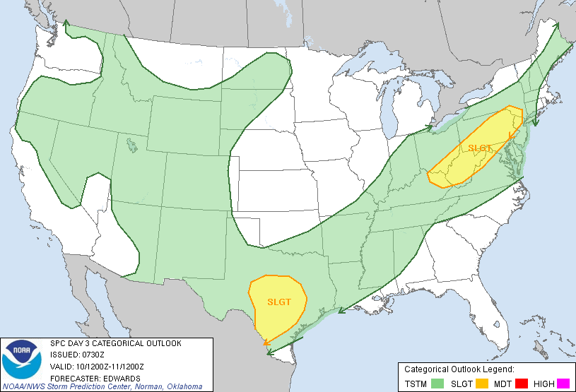
Chances for showers and storms increase for Wednesday and Wednesday night, but lessen a bit each day starting on Thursday into the weekend, as high pressure and warm conditions take control over the weather picture. Beyond Wednesday, more organized precip will most likely wait until Sunday night or Monday morning.

Intellicast

Intellicast

In spite of some chances for showers and storms mid-week, the overall pattern is not conducive to much in the way of appreciable rainfall through this weekend. However, there are pretty decent signals which point towards a much wetter overall pattern by next week, especially early to middle stages of the work week.

Wednesday, May 8, 2013

UNSETTLED SATURDAY, WITH A FROSTY START NEXT WEEK

1. Morning showers thursday should not be as heavy as today's flooding downpours, which were not well-advertised in advance. Decreasing chances for rain as the day progresses, but leftover cloud cover can persist at night tomorrow night. 60s widespread.

2. A break for Friday, but then a risk of a shower and storm will threaten us Friday night, especially NYC and points to the north and west.  Warm temps Friday, with highs in the 70s (a shot at 80 for the urban locales).

SPC has a slight risk for severe t'storms Friday very close to NYC


3.  Showers and storms will be widespread Saturday for all areas. Although it won't rain the entire time Saturday and Saturday night, the risk of one at any point will exist before a slow-moving front crosses our region early Sunday. Rainfall this week will alleviate the very dry spring conditions thus far. Sunday is the better weekend day, with generally fair skies and temps near 70.

Intellicast.com


4. Potential for patchy frost Monday night and again Tuesday night, as very cold mid-May air mass settles in. Chilly temps for this time of year Monday and Tuesday, with highs in the lower 60s. 30s at night for at least one of these nights, but the core of the coldest air should stay to our north. Bares close watch for gardeners.


Sunday, April 28, 2013

MAY SHOULD START MOSTLY MERRY

1. Weakening storm will brush the western parts of the area (including NYC) Monday into Tuesday, with pesky light rain. Temps will stay near 60, but the area will be cloudy until Tuesday afternoon/night. Clouds will clear in unusual fashion Tuesday -- from east to west -- as a blocking pattern establishes itself.


2. Said pattern will lead to light easterly flow off of the relatively cool ocean. This will keep temps in the lower 60s through the week. The further east you head, the more likely it is that temps will be even a tad lower.

3. Thursday/Friday: Our warmest days, but then a slow-moving storm approaches for late in the weekend, which could knock our temps down and offer increasing rain chances.

Intellicast


Accuweather.com
4. Periods of extended warmth are unlikely going further into May. Pattern is bottled up. Blocking high over the Northeast as opposed to our south will promote a strong Maritime influence on our temps. Slow-moving storms as well as the position of the blocking high will keep temps from running too far ahead of schedule.


Wednesday, April 24, 2013

TOP FIVE DRIEST APRIL LOOKING LIKELY FOR NYC...

After a weakening area of showers moves through late this evening into the overnight, the weather will be very tranquil through the weekend and much of next week.  A stray shower could pop up Sunday night or Monday night, but the potential is VERY low at this time for this to transpire.

 As it stands now, the park only has 1.27 of rain for the entire month; the prospects of little to no rainfall the next seven days all but assures that NYC will make the record books for dry Aprils since record keeping began in 1869.


So while in the Mid-West, where it's too wet to plant, we have the opposite problem!

WPC 7-day total precip shows between .01-.10 for the area through next Thursday 5/2/13


The pattern could turn wet, cool and stormy again in the first full week of May, as a cool pocket aloft may try to churn up a coastal storm.

But until then,  at least the next 7 days and probably beyond, spring is in full swing, which should make a lot of people's hearts sing.

Intellicast

Sunday, April 21, 2013

WEATHER ROUND-UP FOR THE UPCOMING WEEK

The week will start off on a cool, breezy note, as clouds and moisture build for Monday into Tuesday. Temps will be held in check, so that readings remain below their typical mid-April levels; highs will stay in the 50s for all areas through Tuesday.

NOAA: Threat of frost tonight in areas in blue


A storm system will track to our south and east, with the best shot at light rainfall Monday night into Tuesday. Overall though, the bulk of the precip will stay off-shore and most areas will see little to no rainfall. The best chances for rain would be for the far southern and easternmost portions of the region.

WPC Forecast for 7am Tuesday shows the storm well south of NYC


Wednesday is dry, sunny and a bit breezy; it should be our warmest day of the week.  A quick shot of rain and some thunderstorms moves in at night into the overnight; this will give way to a stray leftover shower and slow clearing for Thursday into Thursday night. Most of Thursday should be dry for NYC and points to the north and west. 

There can be a stray afternoon shower on Friday, but overall, the pattern the next seven days is a fairly dry one!


Temps should hover around normal levels over the weekend, with Sunday being slightly warmer than Saturday. Some clouds should arrive by Sunday afternoon, with even a few showers advancing in at night Sunday night. 


Intellicast Temps: