Sunday, October 21, 2012

WARMTH TO DOMINATE THE LAST FULL WEEK OF OCTOBER

COLD HALLOWEEN WEEK LIKELY, WITH POSSIBLE COASTAL STORM LATE IN THE WEEKEND...

PREDICTABILITY OF FORECAST PERIOD THROUGH FRIDAY-HIGH
PREDICTABILITY OF FORECAST PERIOD SATURDAY-TUESDAY-LOW

1. After starting off cool, October will likely end up being a warmer-than-average month overall, with drier-than-average conditions.


2. TEMPS: mild is the rule through Saturday, with highs near 70 most days.  Cooler Wed/Thursday, with clouds prevailing and onshore winds leveling temps to near normal (low 60s). Late-week temp spike offers the very real possibility of temps soaring into the mid to upper 70s Friday for NYC and points north and west. 50s at night.

3. PRECIP: Best chance area-wide is Tuesday night, with showers a good bet. Otherwise, it's mainly dry, with only a risk of a shower wed/thursday. Wild-card will be late week interaction with system in Caribbean and oncoming cold front for Sunday into Monday.

4. Details are unknown, but said interaction with a developing tropical system, the clash of true winter temps versus the exiting summer-like air-mass and a full moon may be the ingredients needed to produce a very powerful east coast storm in the Sunday-Tuesday period. Bears very close watch.


5. Cold Halloween week likely, with temps in the low 50s to end October and open November. Cold air will persist through the first weekend of November.

PROJECTED PATTERN NEXT WEEK SHOWS COLD AIR LOCKED IN


6. Daylight savings will end the weekend of November 2-4. 

Tuesday, October 16, 2012

WEEKEND BEGINS WET, BUT NO NEED TO FRET

PREDICTABILITY OF FORECAST PERIOD: MEDIUM


The storm system for the end of the week is taking shape; the models are coming into better agreement and as such, are pointing to a wet Friday before things start to clear out Saturday. The idea of the storm lagging behind for much of the weekend is being discounted now, as enough of a push upstream will allow for slow clearing through Saturday and Sunday.

NOAA POPS FRIDAY 


Rainfall on Friday looks to be widespread and long-lasting. The higher amounts look to fall north and west of NYC, where over two inches of rainfall can materialize. However, most areas look to receive half that much, with generally around an inch of rain expected at this time. The long duration of the rainfall will mitigate the prospect of any urban flooding.
 
As discussed earlier, since the Friday freeze-out, this is a somewhat mild pattern overall. 

INTELLICAST TEMPS NEXT SEVEN DAYS


The first part of October ran behind the normal monthly level for Central Park, but has since rebounded.  Based on the data, we should anticipate that these types of fairly seasonable – and sometimes milder readings -- will persist into much of next week.
 
NOAA 8-14 DAY TEMP OUTLOOK


10/24-10/30


However, waiting in the wings is a very robust cold pocket, which will make inroads into the western states next week. This air mass will likely spread out (albeit slowly) and threaten to reach our area by the last week of October.

Sunday, October 14, 2012

A RATHER CALM WEEK, WITH A POSSIBLE STORMY WEEKEND...

PREDICTABILITY OF FORECAST PERIOD: MEDIUM

1. Record cold filtered all the way to the coastal plain on Friday night/Saturday morning. Healthy frost transpired inland, with temps in the 20s.


2.  Few changes to the last video/overview. Exception would be to adjust timing of rainfall for Monday later; instead of sunday night, rain will move through, albeit fairly light, for Monday afternoon and evening.

NOAA New York Facebook page:


3. Tues-Friday are tranquil, with temps in the 60s. Lows in the upper 40s/low 50s. Breezy on Tuesday.

4.  Potential for a prolonged rainfall for the weekend. Slow moving storm system with tropical input could spell flooding rains.  Slow clearing into early next week, with cool temps. Will need updating late this week.

5. Siberian snow cover has markedly increased in the last two weeks. Implications are that cold temps will be much more prevalent on our side of the world.


Thursday, October 11, 2012

FORECASTS FOR FREEZING TEMPS EDGED A BIT SOUTH

From the looks of it, since yesterday, the forecast has shifted potentially freezing temps all the way down to the Connecticut coast.

old image


NWS Freeze "Watches" (issued today)


New Graphical forecast From NOAA. Check out the mid-20s over the Hudson Valley being portrayed!


The models are sensing that the winds will die down tomorrow night just after 8-9pm, which will allow radiational cooling to take hold. But for Long Island and points south,  it's thought that the winds will stay up to prevent sub-freezing readings, with the exception of the Pine Barrens.


Sunday, October 7, 2012

TRUE FALL PATTERN TAKES HOLD THROUGH MUCH OF THIS WEEK...

PREDICTABILITY OF FORECAST PERIOD: MEDIUM

1. Unsettled pattern this week, with many weather systems moving through. Biggest impact of these  will be overcast conditions, wind and showers, which will make things rather cool around here for much of this week.


2. Temps: Warmest day is Wednesday, but showers move through wednesday afternoon/evening.  Sunday and Monday are candidates for near 70 degrees in addition to Wednesday, but that's about it. Cloud cover Monday-Tuesday will also impede afternoon warming.

Intellicast:


3. Winds: Gusty winds will develop Wed/PM and continue into Thursday. Winds will pick up once again by Friday afternoon/evening.

4.  We'll have to watch for a period of rain for Saturday night into early Sunday.


WINTER PREVIEW 2012-2013


GET READY FOR A WINTRY ROLLAR COASTER RIDE!


THIS YEAR’S OVERALL PATTERN: Heading into this year, the signals which foretell cold or mild are once again in a “weak” state. This means that the weather pattern will be harder than usual to predict from a seasonal standpoint. For this reason, the overall consensus is that we should expect a lot of variability during the winter months, as opposed to either cold or warm air dominating the entire landscape. What’s noticeably different about this year versus last year however is the presence of an El Nino state in the equatorial Pacific Ocean waters; as paltry as it is right now, it will still be able to add an element of more storminess to the continental southern and eastern United States by way of inducing an active southern jet stream.  Therefore, unlike last year, the prospect of a dry winter around here is less likely than average at this time.

ACCUWEATHER SHOWS A WEAK EL NINO PATTERN:


Add to that the inevitable shots of cold which will come early in a setup like this, and one can reasonably assert that, at this point, the outlook of seeing at least some formidable snow is a bit higher than average. More on this below.

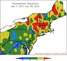
LAST YEAR: By and large, the winter outlooks for 2011-12 were a debacle.
Nearly every weather source out there predicted a cold, snowy winter for the northern tier of the United States. Contrary to this, the northern branch of the Pacific jet stream overwhelmed the pattern, and flooded the lower-48 with incredibly mild air, while at the same time, an area of high pressure dominated much of northeast Canada, keeping bitterly cold air bottled up over Greenland.


 A rather minor snow event occurred in mid-January, but thereafter, mild air once again infiltrated and got even more pronounced in late winter/early spring; it all culminated with a historic early spring heat wave across much of the nation that would have done early summer proud!

WHAT COULD GO WRONG? In terms of the various forecasts for this winter, there’s always a danger that, on either side of the ledger – cold or warm—that the pattern locks in to one extreme or the other, making a mockery out of long range prognostications yet again.


Obviously, the most favored outcome to many would be that the mild air can dominate like 2011-2012. But, unlike last year, signs are already indicating that cold weather will be more prevalent in the lower-48 states in the fall. This is, in part, due to the North Atlantic Oscillation -- which has been running in negative territory through much of the summer months; the result of a negative phase is usually a significant harbinger of cold weather in the east in the early winter months.


In addition, instead of either being quickly scoured out or jailed over Alaska or in Northeast Canada, patterns which feature a negative NAO favor the cold having a much better chance to linger. If high latitude blocking in the form of a negative NAO develops for a time, a severe outbreak of cold and/or potential bouts of heavy snow can grip the region for several weeks at a time, much like we saw back in 2010-2011, and in an extreme way during the 2000s – which were by far,  the snowiest decade since the 1960s in NYC.


Given the prospect of storminess being on the high side with a weak El Nino and the possible implications of the NAO, the idea that winter could turn downright brutal for a time is something to be concerned with.

Here are some selected winter outlooks from around the web:

Accuweather


The Weather Centre


NOAA