RISK OF SIGNIFICANT WINDS: LOW
Watch Now
Wednesday, June 5, 2013

Monday, June 3, 2013
HEAVY RAIN THREAT FRIDAY INTO SATURDAY...
A storm system developing in the Gulf of Mexico may combine with an oncoming mid-west system to produce a potentially heavy rainfall for Friday through Saturday afternoon...


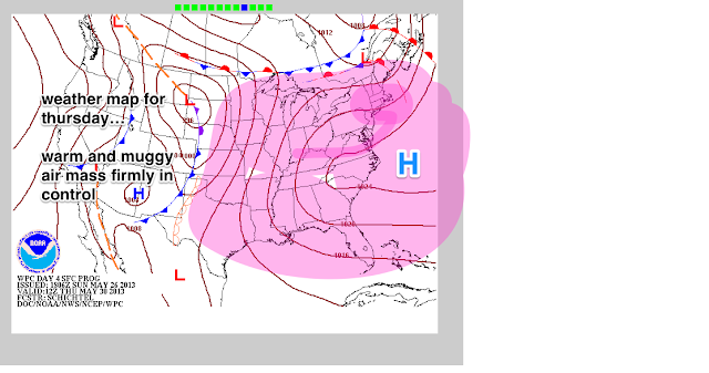
At the very least, conditions will become humid by Thursday, as the winds turn to the south and begin to pump in a moist, tropical air mass...
In spite of the threat of several inches of rain in the worst case scenario (number 2), and in spite of what may become a late week media hype-fest, most of the region can still manage to handle upwards of three inches of rain without any major problems.
The most susceptible areas would be any region near streams and creeks, as well as typical urban/poor drainage flooding on the highways.
The best chance of seeing any flooding would be for Northeast New Jersey, where the soil has taken on a lot of water over the past month in that particular area. Upwards of 2.5 inches would be enough to cause widespread flash flooding

more later...


At the very least, conditions will become humid by Thursday, as the winds turn to the south and begin to pump in a moist, tropical air mass...
In spite of the threat of several inches of rain in the worst case scenario (number 2), and in spite of what may become a late week media hype-fest, most of the region can still manage to handle upwards of three inches of rain without any major problems.
The most susceptible areas would be any region near streams and creeks, as well as typical urban/poor drainage flooding on the highways.
The best chance of seeing any flooding would be for Northeast New Jersey, where the soil has taken on a lot of water over the past month in that particular area. Upwards of 2.5 inches would be enough to cause widespread flash flooding

more later...
Friday, May 31, 2013
SUNDAY'S STORMS WILL HERALD IN A COOLER WEEK NEXT WEEK
The ingredients for storms to become severe on Sunday was alluded to earlier this past week
 NOAA's official outlook for this Sunday is very close to the original idea, but does not include the coastal sections as of yet for the strongest storms

Nevertheless, widespread storms will make their way through the region LATE Sunday afternoon and night, and linger into much of Monday afternoon, as the front which will cool us down slows to a crawl.

A flash flooding threat will exist for western Sections of NYC and points to the north. To the east across Long Island, lesser rainfall amounts will take place through Monday night, but the idea of at least an inch of precip area-wide is a good bet.
Once we get past Monday, things look pretty dry. Temps will return to normal; the indication is that this will remain so through a good part of the week, with the heat staying well to our south.


Nevertheless, widespread storms will make their way through the region LATE Sunday afternoon and night, and linger into much of Monday afternoon, as the front which will cool us down slows to a crawl.

A flash flooding threat will exist for western Sections of NYC and points to the north. To the east across Long Island, lesser rainfall amounts will take place through Monday night, but the idea of at least an inch of precip area-wide is a good bet.
Once we get past Monday, things look pretty dry. Temps will return to normal; the indication is that this will remain so through a good part of the week, with the heat staying well to our south.
 |
| Intellicast |
 |
| WPC Forecasted High Temps for June 7 |
Tuesday, May 28, 2013
Sunday, May 26, 2013
SUDDENLY IT'S SUMMER!
The cool and windy weather of the Memorial Day weekend will be a faint memory this coming week, as the first sustained summer-like weather pattern of the season takes shape this week in ernest.

 |
| Intellicast
The chances for rain will be limited this week. The first offering at some scattered showers will be late tuesday night into Wednesday, with only isolated chances for Thursday through Saturday. A shot at a widespread severe weather episode with afternoon thunderstorms will arrive around Sunday afternoon; this will need to be watched.
|


Wednesday, May 22, 2013
ANOTHER WEEKEND FORECAST DEBACLE IN THE MAKING ACROSS THE TRI STATE AREA.
The overly optimistic forecast from last weekend may be followed for a second straight week by another miserable turnabout in the forecast for the Memorial Day weekend.
As low pressure departs Friday, another will follow in behind it from the south and then only slowly pull away for Saturday. As such, the potential is markedly increasing that the benign prognostications for this upcoming weekend may be left by the wayside.
 |
| Accuweather |
As noted before int the video, a steady, soaking rain and a few thunderstorms will develop Thursday evening and continue into much of Friday. Another round of rain should follow in behind this first batch of precipitation and last through much of the day Saturday before slowly abating. The potential now exists for another inch or two of rainfall from Friday through Saturday evening (not counting what falls Thursday through midnight with the showers and thunderstorms for the evening commute), with residual cloud cover and windy conditions lingering into Sunday as the main push of rainfall exits for Sunday.
With the onshore wind set to prevail through all of Sunday, temps will struggle into the mid 60s for much of the weekend, with the exception of Monday, where the overall weather picture looks to be its best.
OLD INTELLICAST TEMPS:

NEW INTELLICAST TEMPS:

Temps may try to make a run at 80 Tuesday and Wednesday, before the next front arrives with a risk of a shower Wednesday afternoon and night.
All in all, the stage is set for yet another weekend where forecasts changed dramatically just before the actual period in question.
More later
Tuesday, May 21, 2013
Subscribe to:
Posts (Atom)