Monday, April 13, 2015

THE WEEK AHEAD IN WEATHER....

1. After a glorious Monday, rain moves in after midnight and continues through much of Tuesday morning. Thereafter, rapid clearing ensues, giving the region a nice, warm afternoon on Tuesday. Temps could make a run at 70 inland, but 60s will be more common.

Meteorologistjoecioffi.com 


2. Wednesday is a beauty! Winds from the west will mitigate any sea breezes on the coast. Highs will be in the mid-60s, with 70 possible inland.

3. Retreating high pressure will turn the winds to southerly on Thursday. Thus, temps tumble into the 50s, with more clouds than sun.

7online.com/weather


4. Showers move through Friday night into Saturday, then we clear things out for Saturday afternoon, continuing into Sunday. Active norther jet stream will serve twofold; it'll keep the threat of major storms low and the prospect of changeable temps rather high through the week of the 20th.

Monday, March 30, 2015

AFTER THIS WEEK, A SPRING SURGE...

1. Last snowflakes of the season (probably) for Tuesday afternoon and night. Precip starts as rain Tuesday afternoon, but changes to a mix of snow and rain during the evening, tapering off well before dawn on Wednesday morning. No accumulation expected.

2. After a chilly Tuesday, readings bump up solidly into the 50s for highs for Wednesday and even into the upper 50s on Thursday.  Dry this time frame, with mainly clear skies until things cloud over by Thursday night.

accuweather.com


3. Chances for rain increase Friday into Friday night in the form of off-and -on showers. Temps will be mild under a blanket of cloud cover Friday. Slow clearing Saturday, with a dry Easter Sunday (temps near 50 for highs on Sunday).

7online.com/weather


4. Much anticipated/talked about pattern change sets in next week, which will put the nail in the coffin of winter this year. Highs will consistently be in the 50s in the city and along the coast, with readings higher than this away from bodies of water.

Thursday, March 19, 2015

EARLY SPRING SNOWSTORM ON TAP FOR MUCH OF FRIDAY

As mentioned in the last overview, a storm will deliver widespread snow to the region for Friday. 


Precip will break out between 6am-10am on Friday, and continue to fall during most of the day before ending by early evening. A mix of snow, sleet and freezing rain may occur in the afternoon, particularly near the coast; inland areas will deal with mostly snow, with little in the way of ice accretion. 

Saturday will be dry, but temps will stay largely in the 40s; this is due to the combination of the new snowfall and the expected calm winds for overnight Friday into Saturday. 

Another unseasonably cold air mass will settle into the region by Sunday. Temperatures will struggle into the mid-30s for highs, which is well over 10 degrees below average for this time of year.  Temps will only slowly rebound during next week into the 40s, with the warmest day being Thursday. Thereafter, another shot of Arctic air will try and take a run at the region for late next week. 

Intellicast.com


A period of showers should move in by around Wednesday night or Thursday.  

This well-advertised pattern will continue for the balance of the month and into the first week of April, before winter finally relinquishes its icy grip and yields to more consistent, spring-like weather.

Monday, March 16, 2015

FRIGID FINALE WILL LINGER INTO EARLY APRIL

1. See previous posts/videos as to the evolution of a cold, stormy period, which essentially begins this week and will only slowly let up by around April 10th.

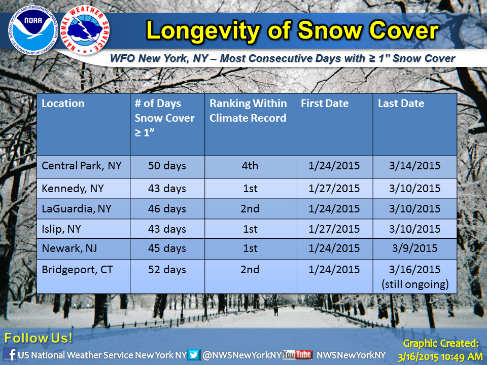
NWS New York on Facebook and Twitter


2. After some light rain in the early morning hours of Tuesday, a cold front will whip through the region. Winds will turn very gusty out of the northwest by midday and skies will clear. Sharp drop in wind-chill values for Tuesday night into Wednesday morning. Actual temps will settle into the 20s, with wind-chill values in the teens/single digits. Winds relax overnight Tuesday/early Wednesday.


3. Wednesday and Thursday are cold and dry, with readings some 10 degrees below normal levels.

4. Snow develops Friday morning, then mixes with/changes to rain by Friday afternoon. Some slushy accumulations are likely area-wide before the changeover occurs. Bares watching.

7online.com/weather

5. After a warm, pleasant Saturday, a strong push of cold temps for this time of year will arrive by Sunday. Some rain/snow showers could move through by Saturday night. Readings for Sunday and Monday will likely remain in the 30s, with lows at night in the 20s

CPC: Probability of below normal temps is above average from 3/24-3/30