Saturday, December 27, 2014

TUMBLING TEMPS AS WE TURN TOWARDS 2015!

NOAA New York on Facebook and Twitter. 


1.  Sunday is mild, but then an arctic cold front crosses the region.  Before the temps drop, light rain arrives Sunday afternoon and evening before tapering off for most areas.

2. Most of Monday is dry, but clouds will fill back in again late in the day. Some light snow could clip  the city and coastal regions on Tuesday, with coatings to an inch of snow in some spots. Outside of Sunday's rain and Tuesday's possible light snow, conditions will be dry through the week.

3. Temps are at their coldest from Tuesday to Thursday, before readings start to moderate by week's end.

7online.com/weather


4. No significant winter storms through at least Friday and probably through January 5th.  Although the overall pattern will feature colder air,  a fast jet stream should keep any disturbances moving through swiftly; these storms will not have time to strengthen, gather moisture and deliver copious amounts of precip.  This is quite a departure from the forecasted active, stormy winter that most circles (including here) were advertising for the eastern states in the various pre-season winter outlooks.

Wednesday, December 17, 2014

DECK THE HALLS WITH WILD AND STORMY

The weather will remain fairly tranquil through Saturday night. Temps will stay in the 40s and the pesky breeze of Thursday will relinquish on Friday.

By Saturday night, we'll see clouds increase and light rain starting to spread in by Sunday morning. After a brief period of light rain Sunday, skies will generally remain cloudy through Wednesday; however, no real significant rain will take shape until sometime later Monday or even Tuesday.

By Tuesday, a powerful storm will be gaining strength over the midwestern states. This system has a  fairly high potential to produce moderate to heavy rains for Tuesday night into much of Wednesday before it ends Wednesday night. As the storm passes through, very mild air will get drawn north and up the eastern seaboard; the dramatic clash of winter and fall air masses will lead to a few thunderstorms Wednesday!  Strong southerly winds will be felt on Wednesday, with speeds approaching 40mph (perhaps higher) and remaining gusty through Christmas day.

Meteorologist Joe Cioffi on Facebook: GFS evolution of storm Tues/Wed

After starting out quite mild on Wednesday, temps will plummet some 20-30 degrees lower by Wednesday night and Thursday on the heels of a strong northwesterly wind and the departing storm.  A few snow showers could develop from time to time for Christmas day, with perhaps a dusting of snow in isolated pockets.

7online.com/weather


The major storm for next week will lead to significant travel delays, particularly across the mid-west. In addition, it is this storm which will likely serve as the catalyst to produce a prolonged cold, stormy pattern from Christmas to New Years Day and possibly beyond.

more over the weekend.

Thursday, December 11, 2014

DRYING OUT AFTER THIS WEEK'S NOR'EASTER....

1. Region finally will be rid of stubborn, strong mid-week nor'easter during the weekend.  Skies will begin to brighten more on Friday, but there can be a stray flurry on Friday night. Temps remain chilly in the upper 30s to low 40s on Friday.

2. Outside of a few scattered flurries this weekend, the region should remain dry, with varying amounts of clouds and sun for Saturday. By Sunday and Monday, we'll see mostly sunny skies and temps rebounding into the mid and upper 40s.

Accweather.com: Geminid Meteor Shower


3. Mainly dry through Tuesday afternoon. A weak, fast-moving system will spark a shot at some quick-hitting rain on Tuesday afternoon before exiting the region early Wednesday.  Winds should pick up somewhat on Wednesday with a chilly northwest flow of air; skies may remain on the cloudy side for mid to late week as another fast-moving system draws near by late next week (Thursday night).

Intellicast.com


4. Potential remains high for active, stormy period of weather for the last ten days of the month. Active southern jet stream combined with renewed cold air masses should make for some periods of disruptive weather during the busy holiday season.

Sunday, December 7, 2014

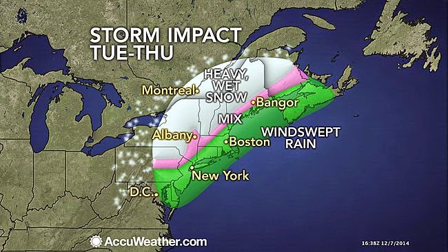
STRONG COASTAL STORM WILL INFLUENCE OUR WEATHER FOR MUCH OF THIS WEEK....

Clouds will gather on Monday with a chilly breeze; northerly winds will begin to turn northeasterly . Light rain/drizzle should develop towards sundown, with fairly steady rain commencing around late evening into the overnight Monday night/Tuesday from south to north. Temps start out in the 30s, but then they rise into the 40s at night. Freezing rain/ice threat is high for Orange County in New York.

Accuweather.com 
Meteorologist Joe Cioffi


On Tuesday, the coastal storm will begin to intensify. A wind-swept, heavy rain will be felt for much of the day and early evening before rain tapers off for Tuesday evening at the coast and in the city.  Elsewhere,  rain should linger north and west of I95 and transition to snow before ending. Moderate coastal flooding will be likely Tuesday and Tuesday night at the coast. Winds could gust as high as 50mph for the city and coast, with 40mph gusts possible further inland.

For Wednesday, we'll remain cloudy. A few quick-hitting rain and snow showers should move through during the day for all areas. Winds will subside, but remain gusty.

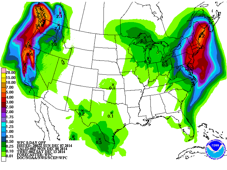
NOAA-5 day liquid equivalent precip totals are a widespread 2"+


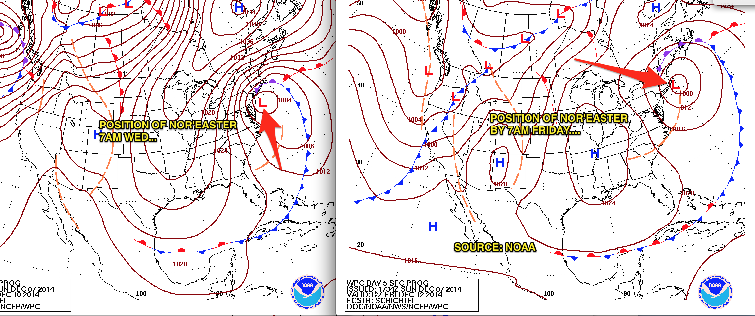
While the steadiest, heaviest rainfall will be north of our region on Wednesday,  the overall configuration of the jet stream will not allow the storm to completely move out of the northeast states. Accordingly, our weather will remain unsettled through Friday, with clouds prevailing for much of the period; scattered rain and snow showers will pose a threat of moving through from time to time, particularly during the day, until the stubborn low pressure is able to weaken and pull further north sometime on Friday.

NOAA: Nor'easter's slow crawl from Wednesday to Friday


Thereafter, our weather will improve even more by the weekend, with temps rebounding into the mid and upper 40s and rainfall chances finally diminishing.

Intellicast.com


In the long term, a cold and stormy regime should continue throughout the rest of the month, with transient spells of above-normal temps. After the 20th, there are strong signs that the overall pattern will begin to "lock in" to winter,  markedly raising the prospects for bouts of sustained cold and disruptive snows during the busy holiday season.

Wednesday, December 3, 2014

UNSETTLED WEATHER FROM SATURDAY THROUGH WEDNESDAY

POTENTIAL FOR PROLONGED NOR'EASTER FOR LATE SUNDAY NIGHT INTO TUESDAY

After dry and cool conditions for Thursday and Friday, warm air will ride up the eastern seaboard Friday night into Saturday; this process, in conjunction with a weak disturbance in the atmosphere will lead to light rain chances increasing from south to north beginning Friday night.  This rainfall will be at its steadiest during much of the day on Saturday before ending Saturday night.  Amounts through this time frame will generally be under an inch. Some of the hilly terrain north of Interstate 78 may start as frozen precip on Friday night.

models/weatherbell.com: Steadiest rains fall during Saturday

Thereafter, attention will shift to a developing storm off of the Virginia coast on Sunday; this storm will meander very close to our shoreline (perhaps for several days) as a blocking high pressure prevents it from going out to sea. However, the ultimate track of this storm and the proximity to our coast will determine whether we see a soaking, wind-driven rain for Sunday nigh into Monday. Regardless, the combination of the above factors and the full moon will lead to some coastal flooding issues for early next week at the times of high tide.

MOON PHASE CALENDAR: 


The probability of seeing heavy snowfall for NYC and the coast is low. 

Intellicast Temps:

Beyond Saturday, there is a low degree of predictability for the early week storm; however, some of the more reliable models are showing some significant impacts for early next week.

Another update will be needed Friday night. 

Stay tuned