Sunday, December 7, 2014

STRONG COASTAL STORM WILL INFLUENCE OUR WEATHER FOR MUCH OF THIS WEEK....

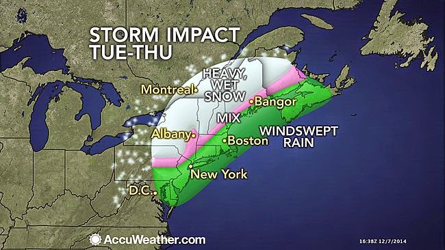
Clouds will gather on Monday with a chilly breeze; northerly winds will begin to turn northeasterly . Light rain/drizzle should develop towards sundown, with fairly steady rain commencing around late evening into the overnight Monday night/Tuesday from south to north. Temps start out in the 30s, but then they rise into the 40s at night. Freezing rain/ice threat is high for Orange County in New York.

Accuweather.com 
Meteorologist Joe Cioffi


On Tuesday, the coastal storm will begin to intensify. A wind-swept, heavy rain will be felt for much of the day and early evening before rain tapers off for Tuesday evening at the coast and in the city.  Elsewhere,  rain should linger north and west of I95 and transition to snow before ending. Moderate coastal flooding will be likely Tuesday and Tuesday night at the coast. Winds could gust as high as 50mph for the city and coast, with 40mph gusts possible further inland.

For Wednesday, we'll remain cloudy. A few quick-hitting rain and snow showers should move through during the day for all areas. Winds will subside, but remain gusty.
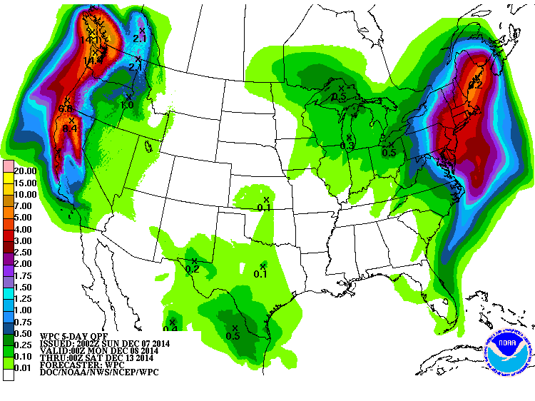
NOAA-5 day liquid equivalent precip totals are a widespread 2"+


While the steadiest, heaviest rainfall will be north of our region on Wednesday,  the overall configuration of the jet stream will not allow the storm to completely move out of the northeast states. Accordingly, our weather will remain unsettled through Friday, with clouds prevailing for much of the period; scattered rain and snow showers will pose a threat of moving through from time to time, particularly during the day, until the stubborn low pressure is able to weaken and pull further north sometime on Friday.
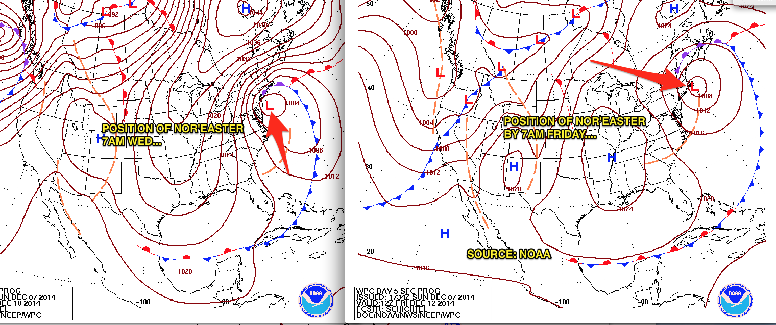
NOAA: Nor'easter's slow crawl from Wednesday to Friday


Thereafter, our weather will improve even more by the weekend, with temps rebounding into the mid and upper 40s and rainfall chances finally diminishing.

Intellicast.com


In the long term, a cold and stormy regime should continue throughout the rest of the month, with transient spells of above-normal temps. After the 20th, there are strong signs that the overall pattern will begin to "lock in" to winter,  markedly raising the prospects for bouts of sustained cold and disruptive snows during the busy holiday season.

Wednesday, December 3, 2014

UNSETTLED WEATHER FROM SATURDAY THROUGH WEDNESDAY

POTENTIAL FOR PROLONGED NOR'EASTER FOR LATE SUNDAY NIGHT INTO TUESDAY

After dry and cool conditions for Thursday and Friday, warm air will ride up the eastern seaboard Friday night into Saturday; this process, in conjunction with a weak disturbance in the atmosphere will lead to light rain chances increasing from south to north beginning Friday night.  This rainfall will be at its steadiest during much of the day on Saturday before ending Saturday night.  Amounts through this time frame will generally be under an inch. Some of the hilly terrain north of Interstate 78 may start as frozen precip on Friday night.

models/weatherbell.com: Steadiest rains fall during Saturday

Thereafter, attention will shift to a developing storm off of the Virginia coast on Sunday; this storm will meander very close to our shoreline (perhaps for several days) as a blocking high pressure prevents it from going out to sea. However, the ultimate track of this storm and the proximity to our coast will determine whether we see a soaking, wind-driven rain for Sunday nigh into Monday. Regardless, the combination of the above factors and the full moon will lead to some coastal flooding issues for early next week at the times of high tide.

MOON PHASE CALENDAR: 


The probability of seeing heavy snowfall for NYC and the coast is low. 

Intellicast Temps:

Beyond Saturday, there is a low degree of predictability for the early week storm; however, some of the more reliable models are showing some significant impacts for early next week.

Another update will be needed Friday night. 

Stay tuned


Saturday, November 29, 2014

DECEMBER OPENS WITH VARIABLE TEMPS AND LIGHT PRECIP CHANCES

1. Pre-Thanksgiving snowfall ideas from here were overdone near the coastal plain. Inland areas mainly picked up between 4-6 inches with isolated higher amounts:

Left: NYC Weather Guy snowfall idea for 11/26/14
Right: NOAA storm total snowfall for 11/26/14

NOAA: Rain/Snow line during 11/26/14 storm

2. Warmer Sunday through Monday night, then below-normal temps for Tuesday (our coldest day during the week) with highs only in the 30s. Temps steady at night Sunday night, with plenty of cloud cover. Only precip of note through the period would be very light rainfall on Monday night with the passage of a cold front. 

3. Tuesday night and Wednesday, we have a good shot at light rain, ending by afternoon on Wednesday.  Thursday is dry with temps in the upper 40s. Another shot at light rain will try and work through the region on Friday. 

Intellicast Temps: 


4.  East-to-west flow in the jet stream will keep prolonged extreme cold and major storms a low possibility through the 10th. 
Accuweather.com

Monday, November 24, 2014

MAJOR WINTER STORM ON THE WEATHER MENU FOR WEDNESDAY AND WEDNESDAY NIGHT

Incredibly, after record high temps for Monday, the stage will be set for the region's first significant winter storm of the season.


The primary hazards associated with this vigorous storm will be most felt north and west of Interstate 95 and points north and west; the primary weather hazard will be heavy snowfall which will make driving very difficult for Wednesday afternoon and evening.

A light rain-snow mix will overspread the region as early as overnight Tuesday night/Wednesday morning. However, the steady, more meaningful precip will get going late Wednesday morning, and continue heavy at times; snow will change to rain for NYC and points south and east, cutting down somewhat on accumulations there. However, north and west of NYC and the coast, snow will take over as the primary precipitation type.


As the low pressure begins to pull away, a period of snow will take place all the way down to the coast during sometime Wednesday evening; this is the best opportunity to see a quick accumulating snow at the city and coast, where a general 2-4" is a good possibility. Areas in and around the north shore of Long Island at the highest elevations could see amounts closer to 6" by the time it's all over!

if you must travel, leave early and in the morning hours if possible, especially if you're driving from south to north.

In the pre-dawn hours of Thursday, all precip will taper off.

Intellicast.com Temps


Behind the storm, it's unseasonably cold and dry through the weekend, with a noticeable warm-up by Sunday.


Saturday, November 22, 2014

POTENTIAL INCREASING FOR DISRUPTIVE, PRE-THANKSGIVING STORM

First, there are no changes to the forecast rationale for Sunday and Monday. See previous posts.

Colder air moving in Tuesday will set the stage for our mid-week problem.

The models are slowly coming into line on a powerful, but fast moving storm for Wednesday into Wednesday night. This storm has the potential to deliver a heavy snowfall inland and a rain/snow mix along the coast.  The track is uncertain:

accuweather.com
A track closer to the coast would mean more snow inland and more rain along the coast. A track further out to sea would mean less snow and less overall impact, but it would make for more snow on the coast (warm air would not push in and change the precip to rain with an offshore track). 

the volume of travel done on Wednesday and the storm's impact on a wide swath could lead to very significant delays and cancellations

Snow  or a rain/snow mix would begin around mid-to-late morning and continue through the day before ending late Wednesday night. 

The exact effects on sensible weather will be ironed out over the next few days
and another update will be needed on Monday

stay tuned.