Saturday, November 15, 2014

AFTER MONDAY'S RAIN, JANUARY-LIKE COLD FOR TUESDAY AND WEDNESDAY

1. Quiet weekend overall, but continued unseasonably cold for this time of year. Sunday actually warms towards the upper 40s, but it's still a few degrees below average high temps. Saturday night is quite cold, but winds are light.

2. Sunday night into Monday: Coastal storm brings a good soaking rain to NYC and the coastal plain. Further north and west across the Hudson Valley, precip should start as snow, making for a slick Monday morning commute. Warming temps means that any frozen precip will be a nuisance; rain will work in as the dominant precip type by mid-morning Monday.

Accuweather.com


3. Monday night, it begins to clear, but the winds start to turn northerly. These winds will help to usher in the coldest air of the fall season; temps will be hard-pressed to get out of the 30s Tuesday and again Wednesday.  Strong winds Tuesday will make it feel like it's in the 20s!!

Intellicast.com Temps


4. Some moderation of temps by Thursday, with highs in the mid 40s; however, readings will be below-normal levels, as our normal high temps should still be near 50 degrees.

Sunday, November 9, 2014

WINTER'S OPENING SALVO ARRIVES AHEAD OF SCHEDULE....

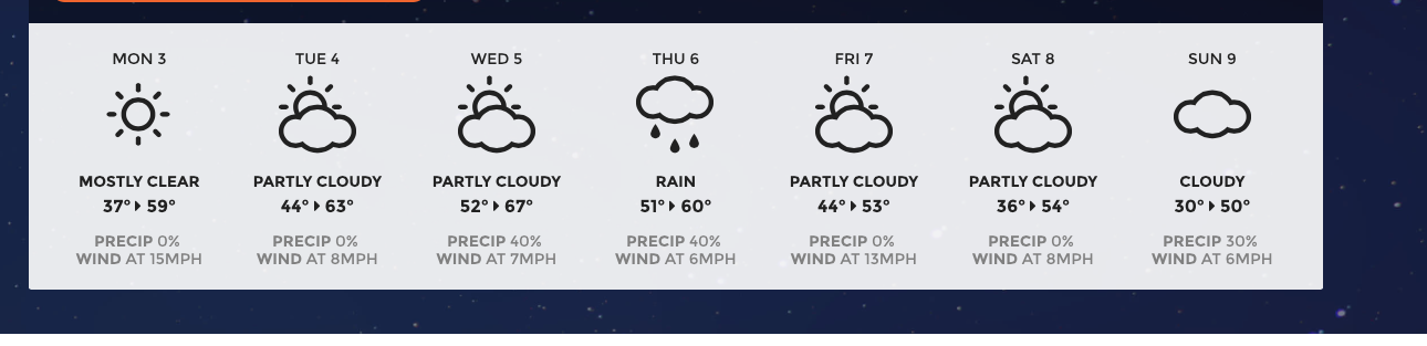
1. Dry through much of this week. Clouds increase on Tuesday as temps warm up nicely. Available moisture is limited, so chances of very light rain will be confined to late at night Tuesday night/early Wednesday morning.

2. By Thursday, the first of many strong shots of cold air will begin to plummet into the region on a stiff northerly wind. Potential is there for a small storm system to give us precip (rain/snow) for late Thursday night into Friday morning, particularly towards the coast. Update will be needed.

3. By Friday afternoon, even more cold air rushes in! Temps over the weekend are stuck in 40s during the day through at least next Monday.

Overall pattern late week and early next week: Cioffi: PIX-11/Facebook


4.  On the heels of the Thursday "clipper low," a stronger, more vigorous storm will develop near the Gulf of Mexico and track northward for early next week. This system has the chance to offer a more substantial round of rain/snow Sunday night into Monday, but models have been inconsistent in terms of the storms' eventual track. Bears watching.

5. Outstanding mid-November cold (compared to averages for this time of year) will hold its grip in place through the 20th. Persistent, blocking pattern is the culprit, along with above-normal snow cover in the Northern Hemisphere. We should expect many days where highs are only in the upper 30s and lower 40s, with lows in the upper 20s to lower 30s area-wide; even colder away from NYC at night!

Rutgers University Snow Lab:
Left: Snow Cover 10/8/14
Right: Snow Cover 11/8/14

Intellicast Temp Forecast

Weatherspark.com: Average highs in November for NYC

Weatherspark: Average time spent in temp categories since 1869

Sunday, November 2, 2014

NOVEMBER WILL BE COLD AND STORMY ACROSS THE REGION

1. Weekend nor'easter was the second straight storm to over-perform when compared to the forecast. Rain lasted the entire day for NYC and points east, with amounts from one half to one inch of rain.

NOAA Precip estimate shows .50-1.00 fell on Long Island for 11/1


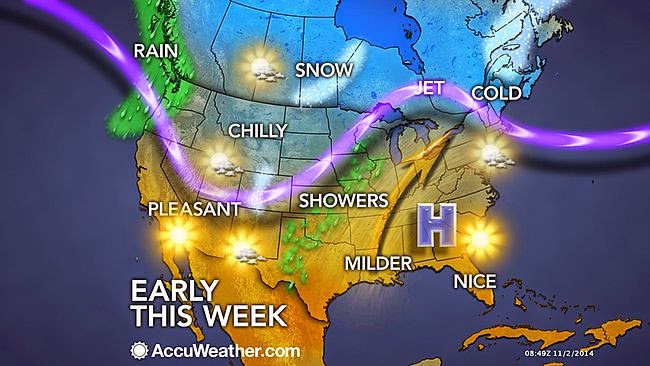
2. Mainly dry through Wednesday, but there could be widely scattered showers Tuesday night as a warm front moves through.  Most if not all of Election Day is dry. Temps start to creep back up after Monday (tomorrow).

Accuweather.com
www.PIX11.com/weather


3. Another coastal storm for the end of the week, with rain and wind likely thursday afternoon into Friday morning. Clearing for the weekend, with cooler temps taking hold.  Windy on Friday night and Saturday. Look for another coastal storm and cold shot sometime during the week of the 9th.

4. In general, an active pattern of storms should combine with slightly colder-than-normal monthly temps through much of November, setting the stage for another rough winter in NYC.

Monday, October 27, 2014

MAJOR COLD “SPELL” LOOMS FOR HALLOWEEN WEEKEND…

1. After a gorgeous Tuesday, temps begin to tumble on Wednesday and Thursday. Threat of rain in the form of showers Wednesday during the day will be minimal; areas to the west and north of NYC will stand the best chances. 
 
2. Calm Thursday and Friday. All of Halloween will be sunny and cool, but clouds rapidly lower and thicken toward evening. 

Intellicast


3. Our first intrusion of bona fide arctic air will hit the region beginning late Friday night and it will last through the weekend. Temps will struggle to get out of the 40s for daytime highs Saturday and again Sunday, with wind-chill values in the upper 30s to low 40s. Very windy Saturday. 


4. Low confidence forecast remains for sensible weather this weekend. Complex pattern evolves as the arctic air plunges southward.  A storm will develop to our south and track northeastward, with both an initial shot of precip overnight Friday night and another shot at precip on Saturday night. The potential is there for accumulating snow in the interior of CT and the Lower Hudson Valley; in a worst case, accumulations could make it down to the coast, as we saw back in late October 2011 and again with the post-Sandy storm in 2012.
 
More later…