Monday, October 27, 2014

MAJOR COLD “SPELL” LOOMS FOR HALLOWEEN WEEKEND…

1. After a gorgeous Tuesday, temps begin to tumble on Wednesday and Thursday. Threat of rain in the form of showers Wednesday during the day will be minimal; areas to the west and north of NYC will stand the best chances. 
 
2. Calm Thursday and Friday. All of Halloween will be sunny and cool, but clouds rapidly lower and thicken toward evening. 

Intellicast


3. Our first intrusion of bona fide arctic air will hit the region beginning late Friday night and it will last through the weekend. Temps will struggle to get out of the 40s for daytime highs Saturday and again Sunday, with wind-chill values in the upper 30s to low 40s. Very windy Saturday. 


4. Low confidence forecast remains for sensible weather this weekend. Complex pattern evolves as the arctic air plunges southward.  A storm will develop to our south and track northeastward, with both an initial shot of precip overnight Friday night and another shot at precip on Saturday night. The potential is there for accumulating snow in the interior of CT and the Lower Hudson Valley; in a worst case, accumulations could make it down to the coast, as we saw back in late October 2011 and again with the post-Sandy storm in 2012.
 
More later…

Saturday, October 25, 2014

PREPARE FOR ANOTHER SNOWY WINTER ACROSS THE AREA

THIS WINTER:

If the consensus holds for a snowier-than-normal winter,   it would be the 6th winter out of the last 7 with above normal snowfall...and that has not happened since the 1880s.


Accuweather.com


This year, many of the same factors that contributed to our snowy pattern last year are yet again in place. A border-line El NiƱo,  a favorable overall water temperature profile in the Atlantic and the Pacific Oceans  and above normal October snow cover in Eurasia should sew the seeds for another cold, snowy winter, with amounts compared to seasonal averages well-above normal area-wide, particularly towards the coast.

One would think (and some would hope) that the odds of beating last year's robust snowfall totals would be low.

But the last time NYC saw back-to-back 50 plus inch seasonal snowfalls was not long ago -- 2009-10 and 2010-11. Indeed,  with few exceptions, the late 1990s through 2013 will -- by far and away -- be remembered for being one of the snowiest periods of weather around these parts since the 1940s!


2013-14 Winter Stats: Courtesy of Weather works inc. 


NY NJ PA Winter Forecast

Weatherbell Winter Forecast

NOAA Winter Forecast

Weather Channel/WSI Winter Outlook

Accuweather Winter Outlook

WINTER 2013-2014:

Last winter saw heavy snows blanket the area in January and February.  NYC recorded 57.3 inches for the season, with many locales totaling similar results.

Things got started on December 14-15, when our first coastal storm brought half snow/half rain to the coast, while dumping heavy snow inland.

The first snowstorm with little to no rain occurred shortly after the New Year, with blizzard conditions, 8-12" of new snow, and bone-numbing cold which followed directly in behind the storm.


A second potent winter storm came around Martin Luther King Jr. Day, with similar accumulations, but less wind. February had a close call early on, but then another winter storm came calling February 13-14, with a blinding snowfall that snarled the morning rush. In the evening, snow changed to a drenching rain for the coast, while areas to our north remained with frozen precip.

Toward the end, the interesting part of winter was what DIDN'T happen; three storms missed the area to the south in the month of March, sparing the area the chance of smashing all-time seasonal snowfall records.

Bottom Line: In the very long term, subtle, but cyclical shifts in the overall hemispheric and water temperature pattern over the next several years may well yet spell the decline of prolific snowy seasons like we've had.  However, in the short run, while maybe not as cold as last year, we should expect to see a season which once again will be capable of producing very disruptive wintry events similar to those we've grown accustomed to, and this is in line with the historical trends of the last 15-20 years.


VIDEO: SHARPLY COLDER CONDITIONS TO OPEN NOVEMBER

Watch Now

Monday, October 20, 2014

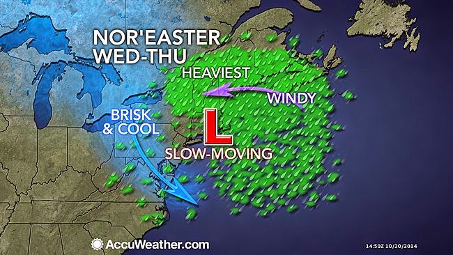
SLOW-MOVING NOR'EASTER WILL INFLUENCE OUR WEATHER FROM TUESDAY THROUGH EARLY FRIDAY...

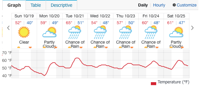
1. Tuesday: Light rain will affect eastern Long Island as well as the northern suburbs of NYC during the overnight hours.  Less rain overnight for the NYC metro area. Showers during the day will be scattered in nature; breaks of sun could develop at times, with temps in the 60s.

2. As the storm takes shape to our south, light rain will develop from southwest to northeast Tuesday night and continue through Wednesday. A steady, moderate rainfall takes shape for Wednesday afternoon and night area-wide, with a few thunderstorms possible.

Accuweather.com

intellicast.com


3. By Thursday, the rainfall once again becomes scattered, with the more organized area of rainfall vacating the region by mid morning. Residual showers could threaten any time from Thursday afternoon through Friday morning, but we should dry out completely for late friday through the weekend.

Thursday, October 16, 2014

A CHILLY WEEK NEXT WEEK

The warmth of this week took us back to typical temps that we'd see in late August/early September. However,  after a pleasant Friday and a warm, windy day Saturday, our temps will become much cooler beginning late Saturday afternoon and night,  and this will continue for the balance of the upcoming week.

Intellicast.com shows the location of the cold front 8am Saturday morning...


In fact, highs on Sunday will struggle to reach the mid-50s; that's easily 10 degrees below where daytime readings should be for this time of year.  It'll be breezy both weekend days, but winds will feel much chillier on Sunday since by then, they will prevail from a northerly direction.

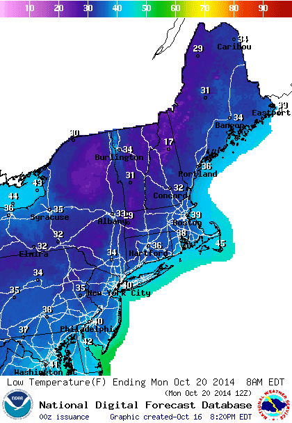
Our first opportunity for widespread sub-40 degree low temps comes Sunday night, especially outside of NYC.

NOAA-Low temp forecast Sunday night/Monday morning


Intellicast.com
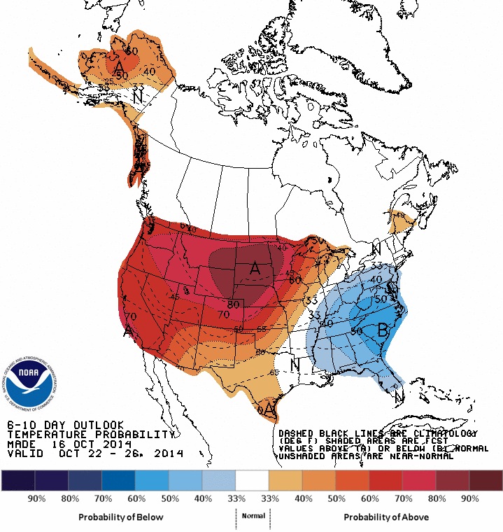
Climate Prediction Center: 6-10 day temp probability shows "below normal" in the eastern U.S. 


The rain we had this week looks to be a pre-cursor for more rain next week. Another slow-moving storm will develop to our south by Tuesday and meander northward during mid-week. This could lead to a period of steady rain and increasing winds Wednesday; while the exact amount of rain for mid-week next week is uncertain, easterly winds will help to lock in the clouds, as well as low level moisture and cool temps beginning Tuesday and continuing through much of Thursday, as the stubborn storm slowly moves away.

Sunday, October 12, 2014

POTENT STORM FOR THURSDAY...

1. Clouds lower and thicken tonight into Monday, but best chances for any light showers should be inland on Monday and Monday night. Warm southerly flow will push temps steadily upward Monday and this will continue through Wednesday, in spite of abundant cloud cover. Nighttime lows will stay quite mild through Thursday night.


Accuweather.com


2. Dry through the first half of Wednesday night. Strong, slow-moving frontal system encroaches upon the region, with heavy showers and some thunderstorms for late Wednesday night through much of Thursday before ending. Total rainfall should average around 1 inch, with some higher amounts possible in any thunderstorms. High temps stay rather mild during Thursday, but temps start to get knocked back towards the low 70s by Friday.

WPC Total Precip 7am Wed-7am Fri

U.S. Drought Monitor


3. Dry weekend, but temps tumble Saturday night with another frontal passage.  Temps will hover around 60 for highs on Sunday, some 15-20 degrees lower than where they will be for mid week! Another potent storm will take aim at the region around Tuesday, with another soaking rain.