Thursday, October 16, 2014

A CHILLY WEEK NEXT WEEK

The warmth of this week took us back to typical temps that we'd see in late August/early September. However,  after a pleasant Friday and a warm, windy day Saturday, our temps will become much cooler beginning late Saturday afternoon and night,  and this will continue for the balance of the upcoming week.

Intellicast.com shows the location of the cold front 8am Saturday morning...


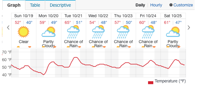
In fact, highs on Sunday will struggle to reach the mid-50s; that's easily 10 degrees below where daytime readings should be for this time of year.  It'll be breezy both weekend days, but winds will feel much chillier on Sunday since by then, they will prevail from a northerly direction.

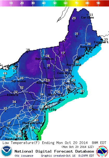
Our first opportunity for widespread sub-40 degree low temps comes Sunday night, especially outside of NYC.

NOAA-Low temp forecast Sunday night/Monday morning


Intellicast.com
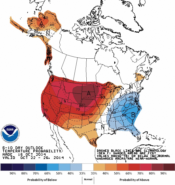
Climate Prediction Center: 6-10 day temp probability shows "below normal" in the eastern U.S. 


The rain we had this week looks to be a pre-cursor for more rain next week. Another slow-moving storm will develop to our south by Tuesday and meander northward during mid-week. This could lead to a period of steady rain and increasing winds Wednesday; while the exact amount of rain for mid-week next week is uncertain, easterly winds will help to lock in the clouds, as well as low level moisture and cool temps beginning Tuesday and continuing through much of Thursday, as the stubborn storm slowly moves away.

Sunday, October 12, 2014

POTENT STORM FOR THURSDAY...

1. Clouds lower and thicken tonight into Monday, but best chances for any light showers should be inland on Monday and Monday night. Warm southerly flow will push temps steadily upward Monday and this will continue through Wednesday, in spite of abundant cloud cover. Nighttime lows will stay quite mild through Thursday night.


Accuweather.com


2. Dry through the first half of Wednesday night. Strong, slow-moving frontal system encroaches upon the region, with heavy showers and some thunderstorms for late Wednesday night through much of Thursday before ending. Total rainfall should average around 1 inch, with some higher amounts possible in any thunderstorms. High temps stay rather mild during Thursday, but temps start to get knocked back towards the low 70s by Friday.

WPC Total Precip 7am Wed-7am Fri

U.S. Drought Monitor


3. Dry weekend, but temps tumble Saturday night with another frontal passage.  Temps will hover around 60 for highs on Sunday, some 15-20 degrees lower than where they will be for mid week! Another potent storm will take aim at the region around Tuesday, with another soaking rain.

Monday, October 6, 2014

A MURKY START TO COLUMBUS DAY WEEKEND LOOKS LIKELY FOR FRIDAY

1. Winds remain gusty tonight, with clouds and light rain developing from west to east. Sun will try and filter through the clouds by mid-morning Tuesday;  in fact, the region should remain fairly dry for much of the day before a second, heavier round of rain arrives during the late evening. A few places may see a thunderstorm at night, as there is some instability present in the atmosphere. Highs will be around 70.
2. Fair and dry Wednesday and Thursday, with breezy conditions Wednesday. Temps will continue around or slightly above normal for mid-week. Clouds build anew by Thursday afternoon.


3. By Thursday night, a slow-moving front will trigger periods of rain through late Thursday night into all of Friday before skies clear from north to south on Saturday. Expect a few hours of steady rainfall on Friday, with only scattered intermittent showers for most of the period in question. Temps tumble Friday and Saturday, as the region is situated on the cooler side of the frontal zone. Skies may take time clearing for NYC south and east on Saturday during the day, before all areas clear at night. Another update will be needed.

Accuweather.com

NOAA high temps Saturday

4. Sunday is fair and dry. By Columbus Day, another system will approach with increasing chances for showers late in the day.

Thursday, October 2, 2014

SATURDAY SHOWERS, DRY AND FALL-LIKE ON SUNDAY

With the exception of parts of Connecticut and eastern Long Island, the region stayed fairly dry this week, albeit under damp, dreary conditions.   As noted in the video this week, Saturday's  potent cold front will be our best chance at rainfall area-wide, but rainfall should average around a half an inch.

Advanced Hydrologic Prediction Center-Total rain last 7 days


After a dry day on Friday (with plenty of clouds), showers will spread into the region overnight Friday/Saturday, and continue through the early morning and early afternoon hours before ending. The rain will be heavy at times.  Winds will kick up and become gusty behind the rainfall from a northwesterly direction, making it brisk for Saturday night.

By Sunday, we'll see a crisp fall day, with temps only topping out in the low to mid 60s for highs. Another chilly night is on tap for Sunday night, with temps in the upper 40s to low 50s.

Intellicast


Monday will be several degrees warmer than  Sunday's, as the winds turn southerly. Thereafter, conditions should become a bit unsettled again by Tuesday, as a series of small disturbances make their way through the region. They will be capable of touching off scattered showers, much like what we saw during the mid-week period this week. Drying will build back into the region by Wednesday.