Thursday, May 29, 2014

POINTS TO PONDER AS WE WONDER (INTO JUNE)

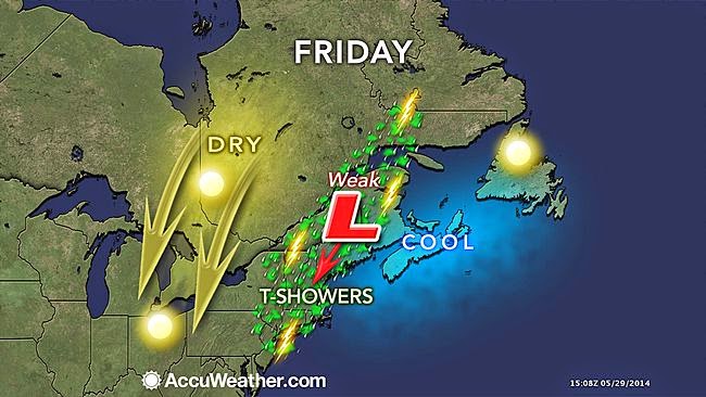
1. Friday: Threat of showers and storms is minimal, but cloud cover will increase. Best chance of quick-hitting rain would be afternoon and evening before things die down.
Accuweather

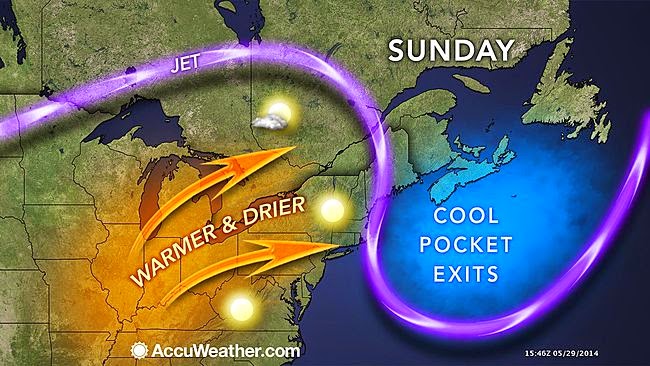
2. Saturday: Best chance of showers should be confined to areas west of NYC as opposed to Friday's chances, where all areas have at least a shot at some rainfall. Otherwise, the weekend should be cloud-free, with generally warming temps beginning Sunday (to above normal for this time of year).

Accuweather


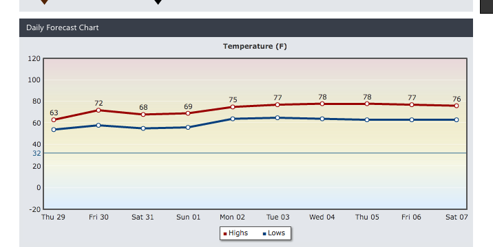
3. Continued warm and dry Monday. Temps will spike to their highest levels of the week for Tuesday into Wednesday, possibly as much as 5-7 degrees higher than what's portrayed below.  However, along with the warmth, we'll see an increase in shower/thunderstorm chances, particularly Tuesday night into Wednesday.


Intellicast.com


Sunday, May 18, 2014

SOMEWHAT UNSETTLED WEATHER FOR MID TO LATE WEEK, BUT A NICE MEMORIAL DAY WEEKEND.

1. Nearby offshore low will spawn scattered showers Monday, particularly over Long Island and eastern Connecticut. Most showers will happen during the afternoon. No rain is expected during the night or in the morning as parameters  of maximum instability aloft and daytime heating are not at their strongest.

Accuweather.com


2. Tuesday is our best day of the work week. Conditions will be dry for all areas as high pressure is able to nudge the stubborn offshore low slightly to the east.

3. Wednesday: Our next front will move through, bringing increasing chances for showers and thunderstorms to the area. Our best shot at widespread showers/storms will come late in the day and at night, before tapering off early Thursday morning.

Accuweather.com


4. After the front crosses, any chances of widely scattered showers Thursday through Saturday will be relegated to afternoon hours, with little to no shower activity during the night and early morning. Again, instability aloft acting in tandem with max daytime heating will contribute to a somewhat unsettled overall pattern late week.

Intellicast.com 


5. Sunday and Monday look like the best days overall of the holiday weekend, but overall the weekend looks very pleasant. Memorial Day may see temps make a run at 80 in NYC, with sunny skies.

Monday, May 12, 2014

AFTER A SUMMER LIKE START, TEMPS RETURN TO NORMAL MAY LEVELS


THREAT OF HEAVY RAINS FOR FRIDAY AND FRIDAY NIGHT
The area should remain basically rain-free through Tuesday night. However, clouds will remain dominant on Tuesday. Temps will hit their high mark for the day on Tuesday in the morning, then begin to level off or even fall somewhat during the day; a wind shift from the off of the cool Atlantic will be the culprit, along with a nearby warm front. A risk of showers will be confined to areas well west of NYC during the day, then increase to all areas as Tuesday night progresses. Rain amounts will remain rather light overall through mid-week. 

Intellicast.com Surface Map Forecast For 5/13/14

The aforementioned warm front won’t be able to move northward on Wednesday. Therefore, easterly wind flow will prevail, keeping our temps cool. Plenty of clouds will persist as well during the mid-week period, but chances for rain will be scattered in nature during the day for Wednesday and Thursday. The best shot at any organized rainfall would be Wednesday night in the form of light rain as the warm front goes by from south to north.
By Thursday, our temps rebound back to above normal levels. As the warm front crosses our region, winds shift back to the south. Any breaks of clouds would send temps soaring well into the 70s to near 80. 

Intellicast.com
NOAA: Highs for Thursday

By Friday into Friday night, attention will turn to yet another front crossing the mid-west and ever so slowly moving through the region. Heavy rain will be a problem for Friday during the day into a portion of the night before it ends. The potential is good for a solid 1-2 inch rainfall through Friday night before we return to a drier pattern for much of the remainder of the weekend. 


Accuweather.com

After Friday, only a risk of a few widely scattered showers during the afternoon exist on Saturday and Sunday. 
Tuesday, May 6, 2014

WARMER THROUGH LATE WEEK INTO THE WEEKEND

1. Warm front crawls through for the end of the week. Its progression from south to north ever so slowly will mean cloudy skies and fluctuating rain chances for the end of the week.
 
2. First chance at any showers will be Wednesday afternoon and night, but areas from NYC south and west will see the highest likelihood of rainfall. Areas east and north will see little to no rain for Wednesday through early Thursday (in spite of this, clouds build in all areas Wednesday night into Thursday).

Intellicast.com Cloud Coverage

 
3. Showers for all areas Thursday morning  will give way to mainly overcast with no rain in the afternoon and at night. Chances for showers will remain widely scattered through Saturday night. Most of the time from Thursday night through Saturday afternoon should be dry with plenty of clouds. Warmer temps and a bit humid for Friday and Saturday.

NOAA: Highs Saturday

Intellicast.com Temps

 
4. Saturday night, a cold front sweeps through with our best shot at widespread showers and thunderstorms. Temps behind the front don’t drop off much. Sunday is mainly dry, with lower 70s most spots.

5. Warm week overall next week, but signs in the long term are hinting at a significant mid-month cool shot

Tuesday, April 29, 2014

THIS WEEK'S SPRING SETBACK WILL ALSO DELIVER HEAVY RAINS TUESDAY NIGHT THROUGH THURSDAY MORNING.

Our cool period of weather talked about last week has arrived; a slow-moving, far-reaching storm system which is responsible for the abrupt change in temps, will be slow to clear the area through the end of the week. In fact, its influence will still exert itself with residual, albeit lesser effects through the weekend.

NOAA New York: Facebook and Twitter


Most spots from NYC east and south won't see much of any rain through today and tonight. However, by late tonight into Wednesday, light to moderate rain will work into the entire region and become steady by Wednesday afternoon.

Our rain for Wednesday during the morning and through most of the day is only the beginning; by the time we approach the early evening Wednesday, most sections will have seen around an inch of rain, with the heaviest rains actually building in by Wednesday night into Thursday morning.

NOAA Rainfall Forecast through Thursday shows Widespread 2"+ rainfall


By Thursday, rain tapers off. Any rain Thursday through Saturday will be mainly in the afternoon in the form of passing showers. Temps will actually warm rather quickly on Thursday as a warm front switches the winds to a southerly, mild direction.

Intellicast.com


**********