Monday, November 11, 2013

Thursday, November 7, 2013
MAJOR MID-WEEK COLD SHOT NEXT WEEK COULD SET OFF A POWERFUL COASTAL STORM
*****Prepare now for winter-like chill for late next week*****
But first,
Friday and Saturday are fair, but temps are knocked back to where they should be for this time of the year. It'll be very chilly on Friday, which will make it feel like it's in the 40s; actual temps will be closer to 50.

Another benign cold front will push through early next week. Dry conditions will prevail, but temps will take a hit later Monday and into Tuesday.
Overall, the upper level winds will continue to usher disturbances and reinforcing cool shots through as we progress through the week.
Once the dry cold front passes through Monday night, the stage will be set for a very remarkable cold shot for mid-November, as temps are likely to plummet from Wednesday through Friday into next week. Readings DURING THE DAYTIME may not surpass 40 degrees, with a strong northwest wind.
But first,
Friday and Saturday are fair, but temps are knocked back to where they should be for this time of the year. It'll be very chilly on Friday, which will make it feel like it's in the 40s; actual temps will be closer to 50.

Another benign cold front will push through early next week. Dry conditions will prevail, but temps will take a hit later Monday and into Tuesday.
Overall, the upper level winds will continue to usher disturbances and reinforcing cool shots through as we progress through the week.
 |
| Intellicast |
 |
| Intellicast |
Once the dry cold front passes through Monday night, the stage will be set for a very remarkable cold shot for mid-November, as temps are likely to plummet from Wednesday through Friday into next week. Readings DURING THE DAYTIME may not surpass 40 degrees, with a strong northwest wind.
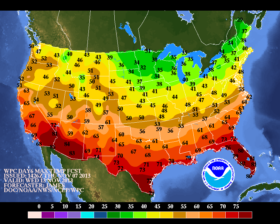 |
| NOAA HIGHS Wednesday |
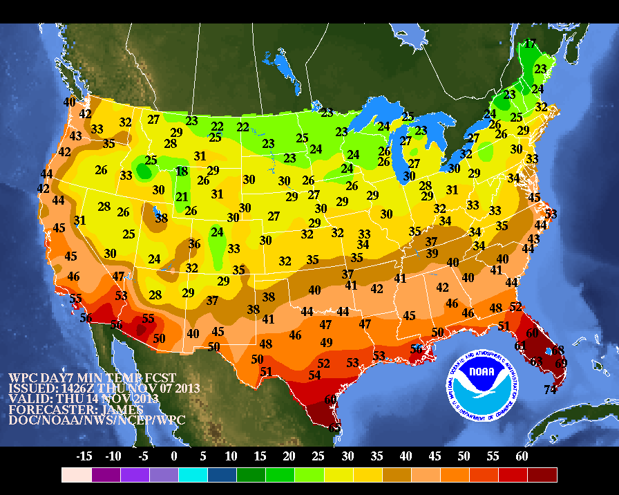 |
| NOAA LOWS Wednesday night/Thurs |
 |
| NOAA Highs Thursday |
The details surrounding the evolution of a potential coastal storm are still in doubt for Wednesday of next week, but the ingredients are there for a significant rain-maker on the coast, with heavy inland snows on its northwest flank.
The last two years alone should be good enough evidence that snow can and will happen in late fall around these parts.
Stay tuned
Saturday, November 2, 2013
COLDEST NIGHT OF THE FALL ON THE WAY FOR SUNDAY NIGHT INTO MONDAY
1. SHORT TERM Through Sunday evening: A few showers are possible over Long Island ant Ct through this evening, before they dissipate.

The partial Solar Eclipse will not be visible tomorrow as clouds dominate until mid-afternoon. Readings for tomorrow have trended downward, so expect a day where many locations barely break 50.
2. Sunday Night: Coldest night of the fall season thus far on tap. Freezing conditions likely will be surpassed in Coastal CT/Central and Eastern Long Island.


3. Well-advertised warming trend towards normal temps for Tuesday through Thursday, before falling off again to below normal for next weekend.
4. Best chance of rain looks to be Thursday, with a good shot at rain in the afternoon. The front should move fast enough so that precip amounts stay around a half an inch at most for any one location.

The partial Solar Eclipse will not be visible tomorrow as clouds dominate until mid-afternoon. Readings for tomorrow have trended downward, so expect a day where many locations barely break 50.
2. Sunday Night: Coldest night of the fall season thus far on tap. Freezing conditions likely will be surpassed in Coastal CT/Central and Eastern Long Island.


3. Well-advertised warming trend towards normal temps for Tuesday through Thursday, before falling off again to below normal for next weekend.
 |
| Intellicast.com |
4. Best chance of rain looks to be Thursday, with a good shot at rain in the afternoon. The front should move fast enough so that precip amounts stay around a half an inch at most for any one location.
DESPITE A DRY SUMMER AND FALL, A SNOWY WINTER LOOKS LIKELY ACROSS THE REGION
 |
| Current Snow Cover in the Northern Hemisphere |
Various forecasts are now coming out for the winter. Many of these projections are banking on the idea that a "weak" El Nino signal will develop in the Pacific; this climatic shift would help to enhance the southern jet stream, making for plenty of opportunities for wintry weather across much of the nation.
There are many factors in seasonal forecasting as we know, but one that is critical in determining our weather pattern over the winter involves the El Nino state in the Pacific, especially in the critical region of 3.4.

A warming signal there very often leads to snowy winters in the eastern states (or at least near-normal snowfall).
The various models are picking up on the warming in the central Pacific.


However, seemingly dry periods can turn on a dime once the conditions become favorable for a "weak" El Nino to take hold leading into the winter months. In fact, some of the closest matches found here using NOAA climate data suggest that the dryness of the fall can be wiped out in a hurry once the El Nino state asserts itself, which it should over the next six weeks.
CENTRAL PARK'S PRECIP FROM JULY THROUGH OCTOBER 2013:
JULY- 2.89 (-1.76 BELOW NORMAL)
AUG-2.85 (-1.59 BELOW NORMAL)
SEPT- 2.95 (-1.33 BELOW NORMAL)
OCT- 0.36 (-4.04 BELOW NORMAL)

TEST CASES: YEARS WHERE WEAK EL NINO DEVELOPED (FROM A NEUTRAL STATE) WITH DRY SUMMER AND FALL SINCE 1950 AT CENTRAL PARK
1966-precip Jul-Dec
JULY: 1.25
AUG 1.89
SEPT: 8.82
OCT 4.64
NOV: 3.47
DEC: 3.18
WINTER SNOWFALL 1966-67: 51.5" OF SNOW
1968-Precip Jul-Dec
JULY: 2.63
AUG: 2.88
SEPT: 1.97
OCT: 2.20
NOV: 5.75
DEC: 4.15
WINTER SNOWFALL 1968-69: 30.2" OF SNOW
2001: Precip Jul-Dec
JULY: 2.04
AUG: 2.56
SEPT: 5.31
OCT: 0.66
NOV: 1.36
DEC: 2.27
WINTER SNOWFALL 2001-2002: 3.5" OF SNOWFALL


Our closest overall matches were probably 1957-58 and 1965-66, which show up twice. They are also both years where conditions in the critical El Nino 3.4 region were heading towards warmer.

Accuweather Winter Forecast 2013-14
Weatherbell Winter Forecast 2013-14
The bottom line: With any sort of significant blocking in the north Atlantic in the form of high pressure building down, a southern jet stream should develop from the emerging "weak' state of El Nino in the Pacific, which should lead to an active winter around these parts, especially January through a good chunk of March. Even with the Pacific looking favorable for snow, a lack of blocking would lead to below normal snowfall, since cold air would not be as available to tap for the coastal locations.
 |
Weather.com: What is "blocking?" |
Wednesday, October 30, 2013
WARM, WHIPPING WINDS WILL OPEN NOVEMBER
The biggest weather story over our area for the next 36-48 hours will be the mild temps and the increasing southerly winds.
 |
| NOAA New York: Facebook and Twitter |
Sustained winds will peak from midnight Thursday to noon Friday; thereafter, they will switch to the west and begin to abate for Friday night and Saturday, before picking back up somewhat for Sunday.
Winds of up to 50mph will be possible for the city and points east for late Thursday into Friday midday. Areas away from the coast will see lesser wind speeds, but it will be very breezy in most places.
The timing of the strongest winds may hamper the morning commute for Friday, but widespread problems are not anticipated.
A shot of rainfall in the form of intermittent heavy showers is likely with the passage of the strongest winds from 12am Friday to 12pm Friday before things dry out. Most places near the coast will see no more than 0.25 of rainfall; some higher amounts are possible away from the coast – something we’ve grown accustomed to over the last few months.
A punch of cooler air will be noticeable by Sunday, as winds increase again. This time, the northwest flow will knock down our temps starting Saturday evening, with readings holding steady in the low 50s for Sunday.

But In this progressive pattern, colder air cannot hold for long. Temps should rebound to near normal levels by Tuesday of next week.
 |
| Intellicast.com |
Turn your clocks back one hour on Saturday night

Monday, October 28, 2013
Monday, October 21, 2013
LIGHT RAIN WEDNESDAY WILL USHER IN A CHILLY 5-7 DAY PERIOD
The previous overviews are on track.
A coastal storm will scrape the region wednesday, bringing with it raw, windy and damp conditions to the tri state area.
Areas to the south and east of NYC will stand the best chance of seeing liquid amounts up to a half an inch of rain, before precip tapers off late wednesday afternoon. Rainfall should begin early wednesday morning, but should not amount to much more than 0.10-0.20 north of NYC.
Thereafter, the forecasted turn to very chilly, fall-like conditions is on track. Expect breezy conditions through the weekend, with plenty of afternoon cumulus clouds. Any shot of a frost would come Friday night in the outlying areas.
A few very light showers are possible during the day Saturday, with some wet snowflakes possibly mixing in for areas in Orange County and points to the north.
A coastal storm will scrape the region wednesday, bringing with it raw, windy and damp conditions to the tri state area.
 |
| Accuweather.com |
Areas to the south and east of NYC will stand the best chance of seeing liquid amounts up to a half an inch of rain, before precip tapers off late wednesday afternoon. Rainfall should begin early wednesday morning, but should not amount to much more than 0.10-0.20 north of NYC.
Thereafter, the forecasted turn to very chilly, fall-like conditions is on track. Expect breezy conditions through the weekend, with plenty of afternoon cumulus clouds. Any shot of a frost would come Friday night in the outlying areas.
 |
| Intellicast |
A few very light showers are possible during the day Saturday, with some wet snowflakes possibly mixing in for areas in Orange County and points to the north.
Subscribe to:
Posts (Atom)