Sunday, May 26, 2013

SUDDENLY IT'S SUMMER!

The cool and windy weather of the Memorial Day weekend will be a faint memory this coming week, as the first sustained summer-like weather pattern of the season takes shape this week in ernest.

Intellicast

The chances for rain will be limited this week. The first offering at some scattered showers will be late tuesday night into Wednesday, with only isolated chances for Thursday through Saturday. A shot at a widespread severe weather episode with afternoon thunderstorms will arrive around Sunday afternoon; this will need to be watched. 


Wednesday, May 22, 2013

ANOTHER WEEKEND FORECAST DEBACLE IN THE MAKING ACROSS THE TRI STATE AREA.


The overly optimistic forecast from last weekend may be followed for a second straight week by another miserable turnabout in the forecast for the Memorial Day weekend

As low pressure departs Friday, another will follow in behind it from the south and then only slowly pull away for Saturday. As such, the potential is markedly increasing that the benign prognostications for this upcoming weekend may be left by the wayside.

Accuweather

 As noted before int the video, a steady, soaking rain and a few thunderstorms will develop Thursday evening and continue into much of Friday. Another round of rain should follow in behind this first batch of precipitation and last through much of the day Saturday before slowly abating. The potential now exists for another inch or two of rainfall from Friday through Saturday evening (not counting what falls Thursday through midnight with the showers and thunderstorms for the evening commute), with residual cloud cover and windy conditions lingering into Sunday as the main push of rainfall exits for Sunday.

With the onshore wind set to prevail through all of Sunday, temps will struggle into the mid 60s for much of the weekend, with the exception of Monday, where the overall weather picture looks to be its best

OLD INTELLICAST TEMPS:


NEW INTELLICAST TEMPS:


Temps may try to make a run at 80 Tuesday and Wednesday, before the next front arrives with a risk of a shower Wednesday afternoon and night. 

All in all, the stage is set for yet another weekend where forecasts changed dramatically just before the actual period in question.
 
More later

Sunday, May 19, 2013

MID-MAY WILL TURN ACTIVE, WITH WET CONDITIONS TAKING SHAPE ACROSS THE REGION

This weekend's forecast was way too optimistic from just about all sources. And that's putting it lightly.

 The next ten days starting today will be characterized by a lot of bouts with wet weather, including thunderstorms.  The exception will be days where it's completely dry; we're likely to see a brief respite  Wednesday and much of the weekend, but every other day is dicey.

The prospects for storms will oscillate as we head through the course of the work week.  this is due to the fact that a front will be bouncing around our neck of the woods for days. So while at first, the front ushers in progressively very muggy conditions by Monday-Wednesday, it turns cool for the balance of Wednesday, before getting muggy again by Thursday!

Humid air masses and nearby fronts will lead to frequent spells of primarily afternoon and early evening rainfalls this week, which should easily average several inches for most locations.

WPC 5-day rainfall totals


Severe thunderstorms may occur thursday. The ingredients are there for unusually intense storms (more to follow later).

DAILY HIGHLIGHTS:

TODAY; Periods of showers, ending after midnight.

MONDAY: Some clearing, but slow-moving thunderstorms will threaten the region in the late afternoon. Heavy downpours a good bet with any one storm. Storms clear the region by late evening, but fog will develop late.

TUESDAY-WEDNESDAY: Best chance for storms will be north and west of NYC in the afternoon, with lesser chances towards the city and  coast.

THURSDAY: Best chance for widespread strong to severe thunderstorms to develop and move from west to east in the evening.

FRIDAY-MONDAY: Looking dry, but temps will be held to near 70, with 60s at the shoreline.

Intellicast

Intellicast

Intellicast


Overall, a low confidence scenario for the upcoming week, so updates will be needed.

Give credit to Mt Holly Weather Service and Climate Predictions Center for being the most out-front on this week's pattern .

Monday, May 13, 2013

WARMER MID WEEK AND BEYOND...

The chilly May weather to open the week is here, with frost and freeze warnings all over the northeast for a second consecutive night.

Light blue shows "freeze warnings," while darker blue denotes frost "advisories."

Weather Nation

Most areas near the coast (except for southern Jersey) will only experience a patchy frost, but even there, tender vegetation should be carefully watched.

slow-moving clouds will put a lid on frost/freeze chances tomorrow night.

Chances for showers and storms increase for Wednesday and Wednesday night, but lessen a bit each day starting on Thursday into the weekend, as high pressure and warm conditions take control over the weather picture. Beyond Wednesday, more organized precip will most likely wait until Sunday night or Monday morning.

Intellicast

Intellicast

In spite of some chances for showers and storms mid-week, the overall pattern is not conducive to much in the way of appreciable rainfall through this weekend. However, there are pretty decent signals which point towards a much wetter overall pattern by next week, especially early to middle stages of the work week.

Wednesday, May 8, 2013

UNSETTLED SATURDAY, WITH A FROSTY START NEXT WEEK

1. Morning showers thursday should not be as heavy as today's flooding downpours, which were not well-advertised in advance. Decreasing chances for rain as the day progresses, but leftover cloud cover can persist at night tomorrow night. 60s widespread.

2. A break for Friday, but then a risk of a shower and storm will threaten us Friday night, especially NYC and points to the north and west.  Warm temps Friday, with highs in the 70s (a shot at 80 for the urban locales).

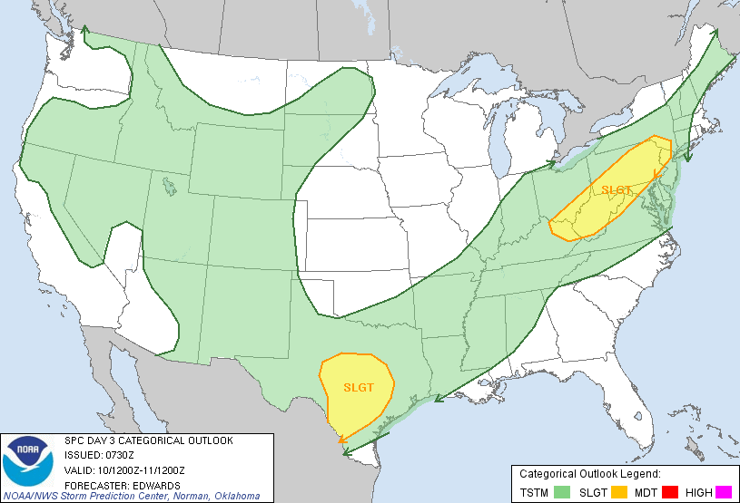
SPC has a slight risk for severe t'storms Friday very close to NYC


3.  Showers and storms will be widespread Saturday for all areas. Although it won't rain the entire time Saturday and Saturday night, the risk of one at any point will exist before a slow-moving front crosses our region early Sunday. Rainfall this week will alleviate the very dry spring conditions thus far. Sunday is the better weekend day, with generally fair skies and temps near 70.

Intellicast.com


4. Potential for patchy frost Monday night and again Tuesday night, as very cold mid-May air mass settles in. Chilly temps for this time of year Monday and Tuesday, with highs in the lower 60s. 30s at night for at least one of these nights, but the core of the coldest air should stay to our north. Bares close watch for gardeners.